Diari de PNG, 6, Mosquitoland

IMG_20160622_160738_1.jpg

Em tornen a demanar que em quede allà per dies o mesos.

Ser tan acceptat per qualsevol societat que visite en fa sentir que he renunciat a tot el que és prescindible i he baixat a la pura i simple humanitat, supose. Siga el que siga això, pareix que em permet una fàcil 1a integració en qualsevol lloc que visite, independentment de la cultura.

M’alce pel matí i està tot boirós, molt xulo

IMG_4139

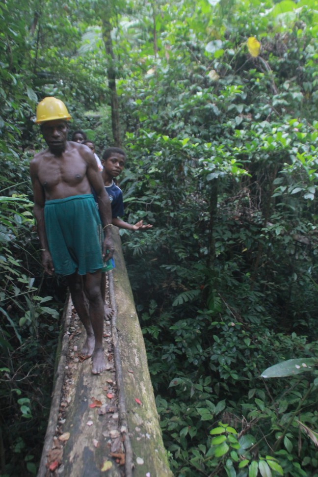
2a fase d’excavar tombes, gasten una pal estreta per foradar la terra i soltar-la, jo palege la terra fora.
Quan hi ha roques (coral·lines, per tant molles) gasten una llarga barra de ferro que les pot excavar colpejant-les fort, el propi pes i inèrcia les trenca.

Desdejuni en arrós aquest cop i més gent que em visita. Em tornen a demanar de no anar-me’n.

Puge cap a la carretera i ara sí que em funciona la càmera. Fotos a la vila i la mini escola primaria, 2 aules en una cabanya de palmes i 2 pissarres, això és tot.

Esperem  a la carretera, cap cotxe passa en més de 2h. El mercat és la parada final del bus 23, un parell vénen.

Passa un cotxe que no para i comence a caminar. Un cotxe em pilla i em deixa prou més avant, en mig de turons de gespa Una torre de comunicació  domina el paisatge, hi camine. 2 poblats familiars (una família hi viu en 2 o 3 cases segons pareix s’organitzen a la zona)  i una escola a l’horitzó completen el paisatge.

M’acoste a l’escola però abans d’arribar un camió de passatgers (PMV) passa i m’arreplega.

El viatge no gran cosa, a cert punt plou i cal posar el toldo, per tant veig poc de paisatge. Em deixa a Angoram on plou prou però això no impedís que milions de grans mosquits vulguen la meua sang. És un poble vora un  gran riu  de nom Sepky, aigua color fang.

El pluvisquer em protegís braços i cos contra els mosquits, però no cames. Em cobrisc les cames de fang per a sorpresa dels locals. Funciona però no és perfecte.

He de buscar una barqueta per continuar.  Com a Vanimo, només tenen dinguis, llantges de fibra a motor, molt poc eficient. Cap passa ara que plou.

Quan para de ploure vuic explorar i en això els locals em diuen que hi ha un vaixellet, dingui, que va riu avall.

El propietari em diu que aniré riu avall amb ells però que espere al final de  la parlutxa.

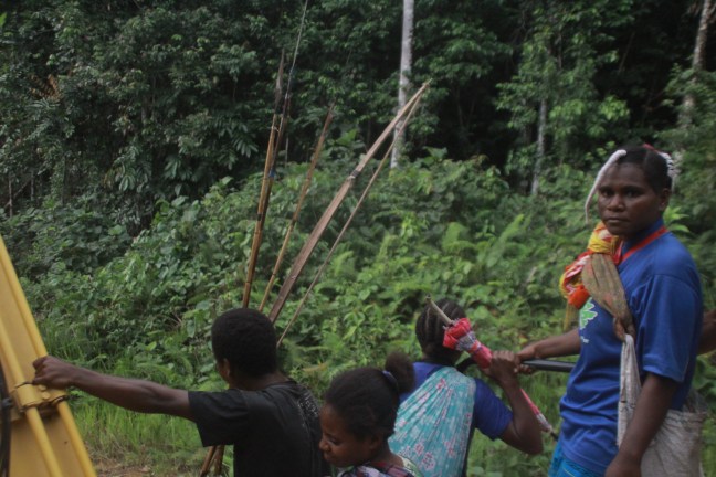
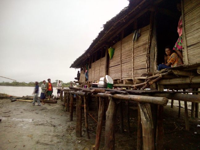
El poble és un conjunt desorganitzat de cases que s’alcen sobre el fang  damunt estaques de fusta, supose que el riu inundarà periòdicament els bancs del riu. Totes construccions tradicionals, cosa que fa bones fotos, però en aspecte decrepit. Llàstima que la càmera no va.

A la posta de sol partim.

Naveguem lentament baix la llum de la lluna plena. El més bonic és vore ací i allà a les ribes la llum càlida de focs.

Em pixe i com estic al davant de la sobrecarregada barqueta intente pixar, però sota l’escrutini de una dotzena de passatgers que riuen i diuen “nature call” el meu cap encara no em deixa.

Mig dorc a damut la meua motxilla. Finalment al 3r intent de pixar ho aconseguisc, dec estar dominant un poc la ment, només  m’ha costat 13 anys :D.

Els locals ho fan sense problemes però.
Com a ironia final poc després parem en un punt en un poc de cobertura de mòbil on molta gent aprofita per enviar missatges i, pixar…

El món  és un lloc dur que no està fet per a humans. Els humans fem el món per nosaltres.

Normalment viatge esperant estar en la pitjor condició possible per justificar els autostops, però ací la pitjor i la millor estan tan prop que he de canviar la mentalitat

Em done conter que ara m’he d’identificar pet un continent, Europa, i no la ciutat, Barcelona, ningú no sap on Barcelona, València, Catalunya i Espanya estan… Bé el futbol no ha arribat ací, és a dir com a  mínim el futbol és bo per donar un poc de geografia bàsica a la població.

2nd, The Interesting bit. Mountain bird head peninsula crossing, West Papua


Comes from 1st
-Second: walk up and then down, and…


You have 100km in front of you, here the wikiloc sketch, it starts at km 41 on that track. I think in 3 days it can be done all walking, for the ones ready for it, but I recommend 4 days with 3 obvious stops on the river crossings. Or skip the last day (24km) as the road is less interesting (paved at half way) and it’s easier to catch a ride. If you come the other way that might change as it shall be less challenging and you can skip altogether the track to get there.


1st Trek

After the bridge the road starts to be unpaved. The first slope of about 8km climbs from 400m to almost 1000m. It’s almost all up with maybe 2 breaks as flatter parts. The views on your back, as you ascend, are magnificent, look back and enjoy the moment!

Fresh it took me 1h and I’m not on shape at all. The road is wide and of crushed rock. I did zigzags to put less stress on my legs. So with less weight and more prepared that shall be done easily and it’s one of the most challenging passes, the are only 2 more like that. On the sides runs fresh drinkable water, nobody lives there!

Just after getting on the top of the pass I got a ride, lucky me, a four wheel pickup. I rode on top of cement sacs and under wood panels.

What follows is mountain road with many ups and downs as it traces the mountains. Striking views.

Around 20km later an abrupt descend to a river valley forced the driver to cool the brakes with water of a hoof on the road. Few kms ahead there is a bigger river and bridge, with 5 houses there (km 63 on my wikiloc track). If you came walking I suggests to stop there to pass the night.

IMG_0006

The inhabitants where fascinated that my ride piked me up walking the mountains 🙂


2nd Part

I continued with my pickup, after the river bridge there is another harsh ascend. We had to stop a couple of times to put rocks on the rear wheels mid slope so the car could muster enough power to clear the stretch.

Another descend cut by a river crossing with no bridge. There you shall wet your pants if you go walking but it’s passable.

I was stopped in settlement of 15 houses and 2 huts scattered in 4 clusters. Strangely they told me the name of 4 villages (3 houses per village?, maybe resettlement from somewhere, as there is no running water there), but the settlement got the name of Meia Selatan.

Continuing about 3km slowly down there is the interesting part of the trek and why it has to be done walking. “Kali (river) Sisu”, I’ll call it Cool Big River 🙂

That shall be your stop, there is a sizable village (with school) less than 1km before the river, and a road construction camp just before the river.

I crossed in 2 of the 3 possible ways (for fun) depending on your preferred method sleep on the village or camp.

The 1st: From the village ask the locals to show you the “jimbatan”, the hanging bridge. If the road bridge is not finish yet (it might take years…) they shall bring you to a hidden small track that crosses a terrific forest using fallen huge tree trunks as bridges on the way. After the tricky path the hanging bridge awaits. No words for that, only awesomeness.

IMG_0084

The 2nd: From the camp ask how to cross, the answer came as excavator. Yeah, cross a river by excavator, exultant awesomeness.

What I did, crossed by hanging bridge, found the excavator on top of the slope, it was evening, so I crossed back with it to sleep, joined by the locals back from hunting, caring their bows and arrows and mobile phone to take pictures with me XD. And next morning excavator cross again!

IMG_0125

The 3rd method, grab a branch and follow the current until you can get to the opposite bank. A kid did it. Cool but not electronics friendly.


3rd Part

Here is where walking is necessary. There is nothing on the other side of the river, and since no cars nor trucks can cross, there is only the 2 feet (or 2 wheels, I was told in the next village that a Russian did that way some time earlier than me 🙂

I starter walking at 8 and by 10:30 I crossed the 10 km to the next village. Good rhythm. After the first slope the terrain flattens, crossing the mountain with its ups and downs.

Terrific views again of pristine forested mountains.

The road in this section is scattered with excavators working, and becomes really muddy at times, but nothing reads impassable.

The town, Ayapoker, has a small shop where to fill your stomach and bags with food. The locals will fill your water (not much running water on the way) and maybe tell you about the crazy Russian and Barcelona guy who crossed before 😀

When I was there a young school teacher from Sulawesi spoke perfect English. Curious to found in the most remote village of this road.

The road slowly climbs all the way. 5km ahead there is another road camp where they offered to feed me. Since i lost 1h in the village to let pass a rain cloud, I pushed on.

A couple of km more a really small town they called Ayay, no place to eat there. I pressed on again. In 5km there was supposed to be next town. Well, not exactly.


Here what happens:

The road climbs to 900m and then down, the views of the valley down are really beautiful. A town in the middle by the river, with a telecom tower and a road climbing on the other side of the valley.

Promising, but the way down is a non visible really abrupt fall, with a excavator trowing rocks on top and a storm coming from the other side, mmm… bad.

Another excavator operator tells me the way down is 1 km or a way around it’s 2 (or so i understood). Not pleased to advance into an invisible way down with half a tone rocks falling form the excavator on top, I decide for the roundabout.

What I thought was a small service road 500m ago on the side of the road is a detour that goes up to 1100m and then down in… 12km, yeah not the best detour when a storm approaches, at the end of the day, and still steppy. My Walking sticks shorten a lot on this way.

When down you can see where the new shortcut is being build.

By the river a road leads to the town but I’m invited to a “hotel” hut by the main road, after crossing the river again.

Either the town (also called Ayay, apparently), or the “Hotel” Papua make a good stop..

I’m told there is no town (next one is Asiti), or houses until 25 kms, that will be false, again.


Optional 4th trek.

From “hotel” Papua I left early, 7:00, after I was forced to take a breakfast.

The road there continues to be unsealed but except for a couple of trunk bridges and a stream crossing, it shows the intention of being a sealed main road soon.

The morning is scenic, with clouds climbing on the rainforested mountain slopes and valleys. But other than that there is nothing to call home, only the gorge viewpoint that I marked on OpenSreetMaps (few metres inside the forest, before crossing the stream) you can find on the Maps.me app.

IMG_0261


The road is not challenging at all anymore and after 10km it becomes paved, maybe 1 or 2 km more there is a small settlement of 5 houses or so (that I forgot to ask the name). There I saw a car pass and I piked it, no reason to walk anymore.


What follows is the most hardcore hitchhike I’ve done, and I been in really hardcore ones already, they are child play in comparison :D.

Sulawesi 26-29, 1, 2, 3 Tolitoli, Treasures Paradise

More, much more!

image

I live on the assumption that the world’s is never boring. If I find it boring is that I’m doing something wrong..

Toli-toli. If Biduk-Biduk (about 100km away across the sea) was a hidden paradise, Toli-Toli is a treasure paradise.

How to start writing down my experiences there in a way that would simply make a bit of justice of what it really is?

Well all starts with contacting the CouchSurfing community of Toli-Toli. It’s still small but the amazing multi employed starter of it (tourist official, university teacher and photographer and something else!) Hendra, together with my host, Alvin,  and his friends and family, offered me one incredible and unimaginable experience.

I’ll go with a intense summary to give a taste, but there is more, much more!
1- One.

  • Sunrise sea market.
Sunrise market.
Sunrise sea market.
  • Royal house.
Royal house.
Royal house.
  • Mythology, with the story of how 3 founders of Toli-Toli transformed on the 3 main tree crops.
  • Visit to the local university full of young energetic students 😀

image

  • Street deer.
    image
  • Coconuts harvest and eating.

image

  • Fast river channel swimming.
    image

image

  • Village at night.

2- Two.

  • Village school visit

image

  • Small boat trip.

image

  • Navigating through mangroves.
  • Hanging bridge to a postcard village.

image

  • Colourful bridge.

image

  • Snorkelling through coral fish nurseries.

image

  • Realizing how noisy some fish are. Exploring shipwrecks.
  • Rest.

3- Three.

  • Holding piton snakes.

image

  • Local smith knife and swords shop!

image

  • Boarding 2nd fishing small boat to diminute islands

image

image

  • Diving to another coral reef.
  • Hunting moontail fish.
  • Dancing with a fish for 15 min.

image

  • Amazing dinner where you pick strange fish to eat, from the day catch.

image

Interview with the head of a village to see the Malu bird (a small penguin like) that’s supposed to be their ancestors and that buries on the sand 1m deep, eggs that are half the size of their body.

4- More much more.

  • Early rising to a red sunrise.
  • Interview with the only guard of the endemic maleo birds, who gets paid only 1milion rupies (150€) a month for his salary and all the expenses of the park.

image

  • Beach.
  • Boat ride with all the colours of blue.

image

  • Beach walking with the white waves breaking the shore.

image

  • Crossing the beach forest, with sea sound on the background, giant spiders!

image

image

  • Maleo bird burring its eggs.
  • Lizard unburring them.
  • Humans unburring them.

image

  • Blue ride back.

image

  • All this marvellous world. All the wonderful people.

image

Continues on:
21st century explorers, 21st century way openers.

Crossing Towuti and Matano lakes from Kendari to Bateleme, Southeast – south – central Sulawesi, Indonesia

Again it’s an Adventure that it was on my plans doing but I got to unfortunate misinformation with my hitchhikes and unreliable maps. Fortunately I got to the point in which I can recommend it and fill some of the information holes I had.

Still it’s not gonna be easy and it would be better if you have your own cross country motorbike.

Starting from Kendari the best is to ask to go to Wanggudu (a small empty administrative town).
From there to Padalere to take the motorbike road to Tocalimbo (or simply  Limbo). It shall be about 100km of crappie road so plan to stay overnight on the road if you started from Kendari or spend the whole day doing it.
That at leas for now will allow you to avoid 5km of hyper muddy mountain road on the provincial road. I did it and the trucks backfell.

There is not gonna be much hitchhikes as the area is mostly deserted, but that shall not put off daring adventurers 😀 (I palmed to do it and by far I’m not the craziest out there).

Then when you get to Limbo (so cool to say that, specially now that the church says it doesn’t exist :D) on the shores of Danau Towuti. There I thought it was the problem, where to go next! However through my alternative way I discovered where to continued from Limbo 🙂

There are few boats and a personality flouting wooden ferry on the morning-noon that go from Limbo (on the southeast shore) to Kampung Baru (on the north west shore) and the other way around, so crossing the biggest lake in Indonesia with magnificent views 😀

Then from there to  Soroako (try the street food on Soroako!) and crossing Danau Matano to Nuha (or Nua) is a easy feat, that’s  the one I did in reverse. There are small 4 legged stable boats that continuously do the 20min crossing for 25.000r, they can also cross your moto (I saw one impossibly carrying 3 motos and many passengers :P).

image

From the small 8 houses settlement of Nuha to Bateleme, there are no towns, so the hitchhike is difficult. I had to walk for 1h on the mid day equatorial sun :P. The first half of the road, until crossing the province border, it’s quite potholed but easily doable, after its good road, shadowy by rubber trees close to the end.

On addition there is a road from Nuha  to Malili, around the lake, but considering that the Alpha male took the wheel of my ride at that point, but was instead copiloting until in the potholed road, then I assume the road is terrible from there on and you need experience. The beginning did look terrible.

I would say the crossing takes at least 2 days depending on the boats that you find to cross Towuti, but count on 3 days to be sure.

As always count on people super happy to see you, many pictures taken of you, remoteness, untouched scenery, cristal lakes, striking views and unknowns 😀

Good luck and Adventure!