The cultural ideal, privileges and industrial-scale evils

Through my studies of cultural loss, I came across a powerful concept from political sciences, the political ends. This is proposed by Morton Gorden within a process of conflict resolution as the “process by which a government sets limits on what enters the political process”(Gorden 1972:vii).

In an evolutionary perspective, governments come after politics, politics comes after public, and public comes after culture. Since my objective is to focus on humans and humanity, for now, I want to abstract that basic schema beyond governments, to a dynamic that captures most of human behaviour.

For that, I reinterpret the first step of the process “goals”, or “political goals” as pursuing a specific “cultural ideal”. In other words, political goals are culturally generated representations of desired final states.

In that framing, I claim that we can see the political process as the path towards the fulfilment of representations of cultural ideals. Even without a government or collective decision-making, as long as there is an individual who wants to freely express its cultural ideal in a social environment, that can be seen as “politics”.

Simply put, every action to pursue a specific cultural end defines politics.

Goals in a political system reflect patterns in culture. The setting of specific goals represent a choice of objectives from a larger range of possibilities residing within the accessible cultural landscape.

Evolutionarely, my argument is that a cultural ideal, while abstractly shared by a “public”, resides in each of the individuals of that public. While growing up in a public a.k.a. a society, we slowly form a diffuse, ever-changing idea of a cultural ideal.

This sequence: cultural ideal formation – action – politics – ends , is not exclusive to humans, or humanity for that matter.

Let us trace possible evolutionary roots for the pursuit of a “cultural ideal”.

Remember Lekker, the vervet monkey who took over as alpha male, and could eat the popcorn of his preferred colour?

If we accept that the choice in colour of popcorn can be called “cultural”, then Lekker imported his “cultural ideal” when he went to a new group that had a different cultural preference of popcorn colour.

With the alpha-male power and influence Lekker kept eating the colour of popcorn that he was used to eating. By that time (six months later) both colours were equally sweet, so there was no real fitness difference other than the colour. In the case of Lekker, he was able to keep his rather simple “cultural ideal”.

We humans do this conscious and unconscious process all the time while sticking to a cultural ideal. For whatever reason, a “cultural ideal” of how things ought to be is created, and then individuals take constant actions to approach that ideal. In the case of Lekker, he achieved his “ideal” through power. Paraphrasing my earlier definition, these actions were Lekker’s politics.

Again, I call all the actions that one takes towards achieving a cultural ideal, “politics”.

As I’ve written before, Joan Fuster, one famous Valencian intellectual, has the aphorism that “politics is done by you or is done onto you”.

In other words, we are constantly doing politics by expressing or protecting our preferences, and even when not doing so, others will press their preferences and ideals to you. This might be because some humans have a tendency to press their preferences and ideals to others, unlike the vervet monkeys–there is no evidence that Lekker forced his preference of popcorn colour on others.

That’s where conflict arises, our constant cultural dynamics are smelted and we can apply Gorden’s framework.

Another interesting intellectual to summon here is Christofer Boehm. He was a primatologist and anthropologist who developed much of his career characterising egalitarianism and equality in human and non-human primate societies.

One of Boehm’s theses is that primates, us included, show two opposing tendencies, one is to oppress and the other is to fight oppression.

To oppress is what Lekker did when he took over the alpha position. That position allowed him to keep his ways in the new group who ate a different colour of popcorn.

What the difference is between other primates and humans, according to Boehm’s observations, is that in human small scale societies these groups are significantly more egalitarian than other primate groups and large scale societies–despite being a spectrum of social inequality and oppression in these small scale human societies.

This egalitarianism is not because humans have a significantly reduced tendency to oppress others, when compared to other primates, but because the small-scale societies have developed and sustained a set of strategies that effectively manage the emergence of oppressive tendencies and weeds it out before oppressive regimes, like Lekker’s taking over the group.

Interestingly, in many human small scale societies there is no such thing as a permanent “leader” like a Lekker. There is a prestige hierarchy, but leadership roles tend to be emergent and evanescent–situational, task-specific, non-centralised, and often temporary leadership rather than institutionalised or hereditary. In many cases, these roles are shared by a council, the decisions are made in a communal fashion or different leaderships emerge to deal with a specific problem or situation. When the problem is solved, or the situation changes, their particular leadership role can disappear with it like in the case of the axe-makers of the Wahgi.

Going back to cultural ideals, a cultural ideal can pop up, like popcorn, as well as being susceptible to constant change.

The rest of the macaques who, unlike Lekker, adapted to the local popcorn colour had to pay the small price of giving up the privilege of eating their preferred coloured popcorn from six months prior.

In that case, a change in “cultural ideal” had little repercussion other than maybe a reticence to try something they remembered as bitter.

The fact that we have a sense of stability and continuity is even more surprising. Take my grandfather, who had just turned 100 at the time of writing. His World has undergone immense revolutions in worldviews, technological advances, scientific breakthroughs, information and human connectivity, exploration, material wealth, services, ways of living, the concept of family, social bonds, entertainment options… Yet, his life, despite his experience of a civil war and an acrimonious post-war period, has been relatively stable, with a level of continuity and relative comfort unheard of for most of human history on this planet. One hundred rounds around the Sun provide so much and so little at the same time, encompassing the extremes of human existence in one lifetime.

My grandfather, in particular, had no problem adopting the “cultural ideal” of going to school, being removed from it because of warfare, working as a labourer to provide for his family when his father passed away after the war, living in a fascist autarkic economy and then a Catholic capitalist dictatorship, finding a wife – late by the standards of his time – owning a vehicle, benefiting from an incipient welfare state in terms of social security, healthcare and public education for his children, supporting his wife in opening a business, integrating into the European market and benefiting from an influx of wealth because of the valorisation of oranges, experiencing a transition to democracy, public nudity in the media and on the beaches, gifting a home to his children, taking early retirement, receiving a pension, travelling, and even accepting something as strange as homosexuals constituting a legal family and having the right to adopt children.

Throughout these continuous transitions, my grandfather’s “cultural ideal” reconstituted itself one way or another. Other aspects of that ideal have held strong, such as how an orange field should properly be tended, how my haircut should look, or how youngsters should care for elders.

Continuously, change was pushing against his “cultural ideals”, and those of his fellow elders, through technology, conflicts, discoveries, interconnection, integration, exposure and innovation. In the process, their individual “cultural ideals” changed without much push or pull, as if Lekke had adopted the local popcorn colour instead of his preferred one.

Most likely, most, if not all, “cultural ideals” hold little to no intrinsic value as long as holding them does not take one too far from the demands of reality. Reality, then, is just a selective pressure that constantly reshapes individual “cultural ideals”, while the Sunrise Paradox allows societies to be reshaped in the intervening periods.

In a sense, variation in “cultural ideals” is neutral as long as there is no selective pressure, as in the case of the preferred popcorn colour when both colours were equally sweet. The main difference is that cultural ideals might be reshaped constantly and, potentially, at striking speed throughout a human lifetime, though limits might exist on these changes.

The existence of the concept of “humanity” itself, and how it has expanded across human populations around the planet, represents a change in “cultural ideals” for hundreds or thousands of societies.

For most societies, what constitutes a person, or a human, is deeply intertwined with membership of that society, as we have seen in the case of ethnic categories.

Many small-scale societies call themselves “people”, “persons” or “humans” and, by implication, consider others to be “non-humans”. Moreover, across the continents, many groups call those who speak different languages “mutes” or “deaf”. It always makes me smile that Slavic languages use a word meaning “mute” to refer to Germans. For example, in Czech, Germans are Němci, which translates as something like “mute” or “silent”. Surely, German must sound to them, and many others, as if one wishes its speakers did not know how to speak German – apologies to German speakers here.

For most of human history, who speaks the language, or wears the same kind of tattoos and body markers, is WHO a person is. Others are just that: others. Interestingly, others can be a mixture of mythological creatures, animals and other beings that interact with real people but are not themselves considered people. Of course, there are ample exceptions to that in-group/out-group division, and cases of individuals from other ethnicities being adopted into groups that see themselves as the only people do exist. We even practise that kind of adoption with animals or inanimate objects like rivers, which acquire personhood through a system of beliefs, or even legal systems.

The fact that “humanity” exists as a global, all-encompassing term that includes every individual of the Homo sapiens species is something that has had to be built on top of the systematic destruction of “cultural ideals” that had clear definitions of what a “person” is.

What a “human” is fascinates us constantly, across all areas of existence, even when we look to the past. Through my research, I have had the opportunity to work with Neanderthal experts. Despite being considered a different hominin species, we now know that Homo sapiens repeatedly reproduced with Neanderthals, and that all humans outside sub-Saharan Africa are descended from Neanderthals.

The biological definition of “species” becomes blurred here, as Homo sapiens and Neanderthals could reproduce. My colleagues would have no problem referring to Neanderthals as “humans”. To this day, there is a profound debate about how “human” Neanderthals were. To engage in that debate, academics usually base their hypotheses on perceptions of their cognitive capacities and the cultural artefacts that can be found in archaeological contexts. In a way, this means outsourcing what it means to be human to what a given population, tens of thousands of years ago, could leave in the sediments of its settlements.

Again, our artificial classifications based on physical characteristics and cultural or ethnic ones get mixed and blurred, and we extend our newly minted concepts to tens of thousands of years ago. In the case of Neanderthals, this is mostly an academic or philosophical exercise. But who, or what, constitutes humanity has had, and will continue to have, repercussions for generations to come.


The deep fall, from privilege to mass evil

Changing the cultural ideal, like in the case of my grandparent 100 years, or what it means to be human, or the popcorn colour, sometimes seems to be quite neutral, and easy to transition from one state to the other.

However, other changes seem to be torturing for the ones experiencing them and happen at a high cost in terms of well-being for all the ones being involved.

For primates, losing other privileges, like the spot as the alpha male can be much more emotionally gruelling. No more choosing of the best food, being cuddled and deparasitised more than the others, abundant sex… Losing all of that when one is used to it sucks. So it makes sense that evolutionarily we have inherited this strong emotional attachment to privilege.

When I was at a top research institute, the head of the department took a liking to me, so we started organising weekly meetings. I really appreciated that privilege because the guy was hyper-busy and difficult to reach. I also was invited to be a “permanent visitor” to the department, meaning that my access to the institution would be prolonged for as long as the director wanted. I really liked the atmosphere there, beyond the director himself. My colleagues were gorgeous, I made many meaningful friends, the intellectual landscape and seminars were enriching and engaging, and a lot of scientific effervescence and advances were happening there in real time. Also I had access to a climbing wall and free sauna. I love both of these.

I left the institute and went travelling. I had an online meeting with the director and I forgot to cancel it because my mind was somewhere else. He did not take it kindly. I kept joining to the weekly online group meetings, but the interaction felt colder than before. A few months after I wanted to come back for a few weeks visit, and I was told through the administrators that I no longer had not that privilege. I did visit for one day, but I was told by the administrators that I was not being welcomed. I kept appearing at the online meetings still. But after a couple of appearances I was notified that I was begin cut off from access to the digital infrastructure. There were other details, but the important thing is that it felt bad, really bad, terrible, awful. The emotional upheaval, even though it was a slow-motion train crash, felt like one of the worst emotions of my life. I felt guilty over my own actions, but also a sense of powerlessness and injustice.

Luckily, I have this coping mechanism of doing cold dips. Losing the heat of your body quickly reminds you that there are other things in life.

After the final notification of being removed from the online groups, I went for a cold dip on the Baltic Sea in February, and it hit me. The emotional disturbance that I was feeling was the aggregation of losing privileges.

I could understand how that emotion, over thousands of generations of evolution, could potentially build this impressive force of needing to have power to oppress others, to keep the privileges in place. This is my speculation, of course, but the emotional upheaval hints at deep origins.

At that time I probably would have sold my soul if I had the option to gain the kind of power to reverse the perceived injustice and bring back my privileges.

Thankfully, I did not have that option to sell my soul. Plus a cold head, and body, helps to relativize things. Also, the understanding I gained through that upheaval is another coping mechanism for me. Gaining that insight at the price of that privilege felt like a comfort price. And life continues.

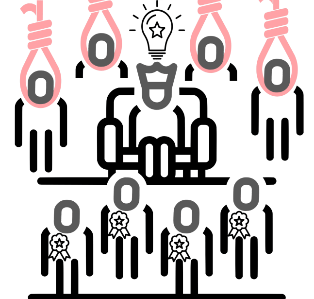
My personal experience of losing paradise, losing privilege, combined with the concept of “cultural ideals” politics and oppression allows me to connect with the concept of evil.

I will frame “evil” as understood by the interview with Ben Ferencz, one of the prosecutors of the Nuremberg trials (who was 98 at the time of the interview). In his view, the evil he has studied all his life after the Nuremberg trials was when humans rationally, and cold-mindedly, pursue the oppression and extermination of others at a massive scale.

As he put it:

people in very high places, people of good education and high rank are quite competent at becoming mass murderers against any group that they think threatens either their nationality or their religion or their economic circumstances. I have seen that. These are not crimes committed by devils with horns. These are committed by educated, well intentioned, patriotic people.

Ben was the chief prosecutor, he was 27 years old at the time of the trials. He only had space to prosecute 22 people out of more than 3000. Here is how he selected the ones to persecute:

I had at least 3000 people on detention. All of whom were complicit in mass murder. I selected who to prosecuted based on several factors. First of all, we have them in captivity. [...] I picked those of the highest rank and then checked out their background, from the Nazi party records which we captured in Berlin. Those who had Doctor degrees, and had... Or generals, they got priorities. I picked out 21 or 28, it was we only had 22 seats in the dock. Is that absurd? Of course it is absurd. There were only 22 seats in the dock for the Hermann Goering trial, so we have a selection.

From then on he studied all the cases of genocide, mass murder, war crimes, organised slavery and heinous crimes done at a massive scale across cultures across the planet. He wanted to understand of how people who were so well trained, spoke many languages, had multiple degrees and PhDs were able to do what they did in the final solution and setting up the extermination camps.

His conclusion on what motivated humans to engage in such dark, evil, cold-minded initiatives is that humans do such massive “evils” to others under three motivations: religion, ideology or keeping of privileges.

The third one resonated with me. It was the first time I heard that privilege could be a fundamental part of human nature.

Moreover, the other two motivations–religion and ideology, or patriotism–could be easily seen as cultural mechanisms to regulate privilege through the exercising of power, or its removal (like in revolutions). If Ben’s observations hold true, this might suggest a possible evolutionary mechanism linking the evils of mass murder and privilege.

As with the opening of this texts, understanding the dark side of humanity from a non-judgmental way would be part of our effort.

Understanding that many of our dark dynamics might come from a strong, evolutionarily build, and shaping an emotional package. Often, parts of ideology and religions build on that emotional package to redirect the emotional dynamism of losing privilege, or the fear of losing it. These dynamics are important in shaping what humanity wants.

If we do not develop the cultural infrastructure to regulate the dynamics of privilege we, in societies where oppression can reach industrial scale, and the lack of effective mechanisms to fight it–as the small-scale societies that the likes of Christopher Bohem and James Woodburn described– we are poised to repeat these monstrous acts.

Then, it will be important to understand how, when and in which ways cultural ideals are created, sustained and shaped, because in cultural ideals many privileges are often stored.

Interestingly, with Lekker I have been writing about his individual “cultural ideal” and his actions can be called politics as “the actions taken towards a political ideal”. Both of these are concepts, “cultural ideal” and “politics” here are seen from an individual perspective.

However, what we want to focus on are shared cultural ideals. These, after all, are the ones that truly drive the kind of oppression that genocides and slavery imply. Yes, we humans have that in us, do we want that?

Previous
Global visions to global ideals

Whatever process we focus on to achieve a “global ideology” would be far from any given form of that ideology. However, as we have seen, a “global vision” already exists in certain technical areas. These areas can be seen that as having reached de facto global standardisation. Other process might follow the technical dynamics, we shall investigate what, and how, other aspects of what it means to be a human can reach global ideals.

Similarly with languages, and the primordial diversity that we illustrated when talking about first encounters between diverse human groups, historically the differences between human populations have been enormous, testing the limits of what it means to be human.

Cultural groups have organised themselves in a wide variety of ways, from the way unions are made, kids are raised, division of labour constructed, ways of seeking food and refuge, medicine, artistic expressions, ways of keeping the group knowledge, religious visions and practices… Almost every aspect of what characterises to be human has experienced an explosion in diversity, with the only commonalities being that these aspects are shared by virtually all human populations. Reproduction, food, shelter, language, body modification/ornamentation, artistic and spiritual expressions, being probably the main ones.

Humans also seem to share multiple universal –or quasi-universal– characteristics. As we have seen, these are the smiles and laughter, pointing towards things, the taboo of reproducing with your mother or your son, a division of labour based on gender, food based taboos, religious beliefs and afterlife, a cosmovision, oral traditions and stories, rituals, music and arts, ethnobotanic knowledge, modification of the environment, humour and the use of technologies such as fire, spears, hammers, strings, ropes, baskets and other such tools. Maybe also the fact that we usually laugh across cultures when somebody falls! That is difficult to prove universally, still, it seem that, at least across ten distant foraging societies, pain and misfortune to be a recurring theme.

Although that list of things seems like a huge set of characteristics, that is nothing when compared with the astonishing diversity of human culture. To find common ground within this diversity is what allows to ask a common question.

Common ground is important, because, even if a lingua franca is shared by different cultural groups, the concepts that are encoded by that language shall also be shared if need to be mutually understood. For example, it is useless to have a word to define a food that is only known by one cultural group. We valencians have given to the world the word Paella, and also an emoji. Paella is both the the pan where the meal is cooked, and the meal itself. Many of the readers might not be familiar with the word paella, you can google it and it would be an easy find. For the ones familiar with the word, probably their knowledge came about by eating the dish itself, and not from reading the definition of Paella. Alternatively, one could have eaten a seafood rice “Arroz con Mariscos” in Peru previously, and when reading about paella, without having actually tried it, been able to understand more or less the concept because these meals, and the experience of eating them, are similar enough even though are called differently and traditional Valencian paella not having seafood, but rabbit and chicken.

In summary, new language and concepts have to be incorporated in the first part by experience, like learning a language for the first time, as newborns do. That takes time. A newborn potentially takes about 2 to 3 years to reach language fluidity through the incorporation and linkage of all the concepts that are being incorporated in the brain, with a vocabulary and a grammar associated. And after that period one never really stops learning, as new concepts and vocabulary keep appearing in ones life, even if it is just the names of new people who are integrated into the human community, such as spouses or newborns. No matter what society we live in, language is something that gets richer and richer throughout ones life.

Similarly, when learning a second language it is significantly easier if the language is close to the one that is already known, especially in terms of vocabulary. Concepts in both languages tend to have words that sounds in a similar way or are closely related. With that the effort to learn is little, because there is a common ground where many bridges are already established. On the other hand, when learning distant languages the effort needed is significant, as each word and concept is virtually new and the bridges have to be build one by one in a process that is somehow equivalent to learn how to speak again, though quite distinct as well, as knowing one language already shapes how one adquires others.

With ideologies, and in general cultures, we can make the analogy with the languages. Similar ideologies have already many bridges of mutual understanding, while distant ones have few points of connection where to build a mutual understanding. Often, for people from one culture to understand the other, there is the need to immerse into the other in order to truly absorb all the concepts needed for a mutual understanding. That is time consuming and impractical.

It is difficult for the members of two different ideologies to truly understand the other. In fact, it is the opposite in many cases, ideologies and identities are on occasion build and defined through the radical opposition to the other. What is reinforced is what makes them different. For example, french youth in the 70s and 80s quickly developed Verlan (l’envers, “the inverted” in french). Velan is a complex argot that flips syllabic order in words. The tradition goes back to at least the XIX c., among prisoners, the underworld and popular groups. But by the end of the XX c., it took off as a generational phenomena to create a code that limits who can understand it. It is generally limited to one or two key words per sentence, while mixed with other known argot. Through language, youth could distinguish themselves and create an identity distinct from the older generations and the wider french society, especially in urban ghettos, where these demographics suffer general societal disenfranchisement. Similarly, in Bouganbille, Papua, the Uisai dialect of Buin, inverted the language gender, not only in nouns but throughout all the linguistic system—pronouns, verbs, numerals, demonstratives and adjectives. Since such change is so profound and systematic, some linguists propose that it was a deliberate act by the Uisai to distinguish themselves from the other Buin communities.

Therefore, for practical proposes, the understanding of the other, and willingness to do so, is what constitutes the basis for a needed mutual understanding.

This process, however, builds upon the biased connections that we already have seen in the previous sections: exchange, commerce, colonization, conquest, universal technical languages, a universal natural language, and as we hinted with maps, nation states.

Upon these connections, there are other levels that we will explore it. Mainly, the export of a set of global ideals by Western powers. This process is not merely limited to the Western World, but I argue that most of intercultural conflicts, oppression and disagreements emerge from a handful of behaviours: how one looks, how one eats, how one fucks, how one works, how one owns, how one kills…

Provably even these last words might arise some emotional reaction in some readers. That reaction, indeed I claim, shapes much of what the aims, and limits, of our question.

Moreover, since the Europeans have proceed to export how one looks, how one eats, how one fucks, how one works, how one owns, how one kills; across the world as a dominant culture, they done so in a brick and mortar way, through infrastructure, and the build up of global institutions.

Previous

Next

Politics of Maps

Finally, for international languages, let us look at a symbolic language that has taken over the World and literally shapes it.

We are talking about maps.

Political maps.

Like most of what we have seen, modern political maps are in part imposed by the Europeans.

Maps are almost as old as pictorial representations of the landscape, as we have seen in the case of [figurative art of the Pleistocene]. Peoples around the world not only represented the animals that surrounded them, but also elements of the landscape, like rivers, mountains or the stars in the constellations. Map-making seems to be quite essential for humans, as even kids can, from an early age, interpret and represent pictorial illustrations of elements of their world.

However, what is quite a Western addition to map-making is the overlaying of political and administrative borders and regions. Clearly delineated areas on a map are only conceptual ideas that exist in the heads of such administrators and their subjects, on top of the geographical depiction of the world.

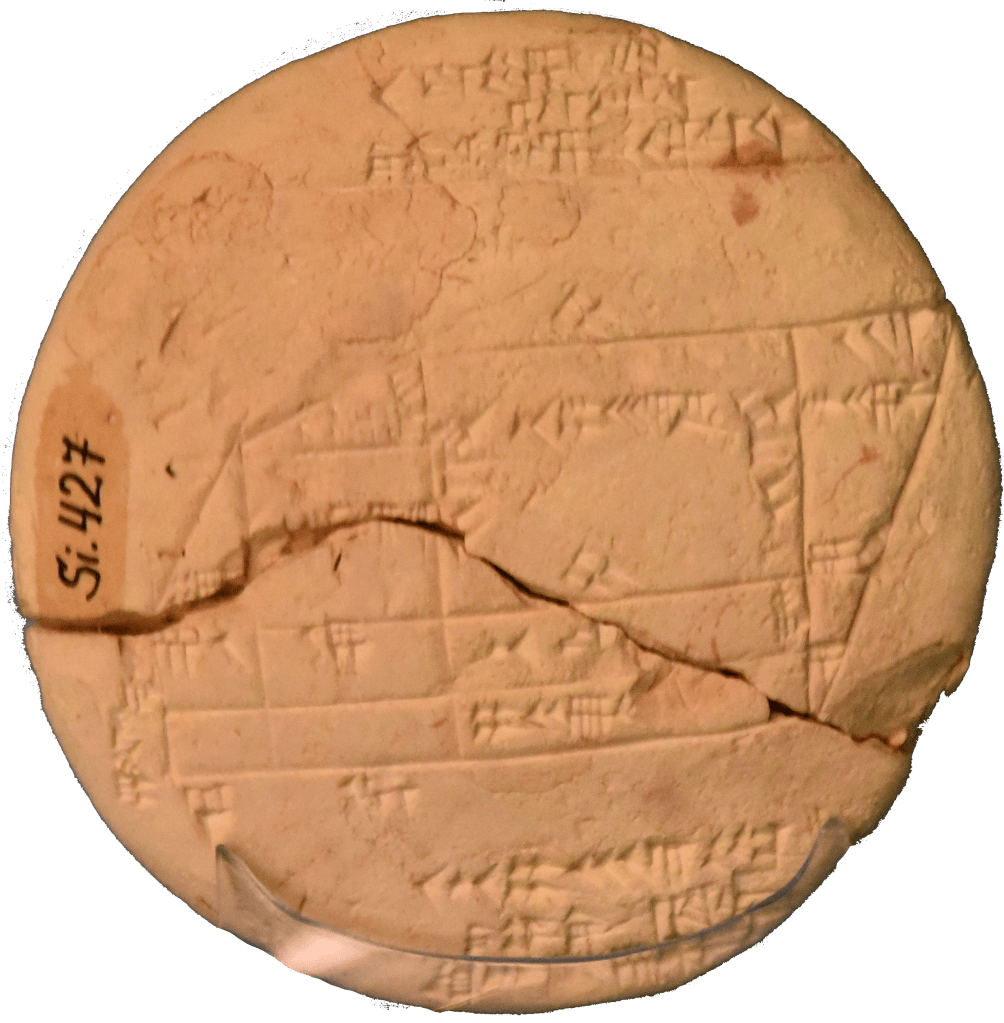
Though, the representation of land “ownership” on maps can be traced much, much older than European map-making. Like with the division of time, the Babylonians had a head start. By 1800 BC, they were already mapping parcels of arable land. The maps were drawn on clay tablets, with the names of the owners inscribed on them. These documents are great for property-owning rights, especially after each year’s floods destroyed the border markers. These parcel maps are also great for taxation reasons, the reason that these maps were created. Still, these plots of land are far from the political and administrative maps that we are so familiar with now.

A cadastral map for agricultural plots, clearly delimited by straight lines. From 1800 BC in Sippar, Iraq. Coded in Akkadian, imprinted on a terracotta tablet; held by the Ancient Orient Museum, Istanbul.

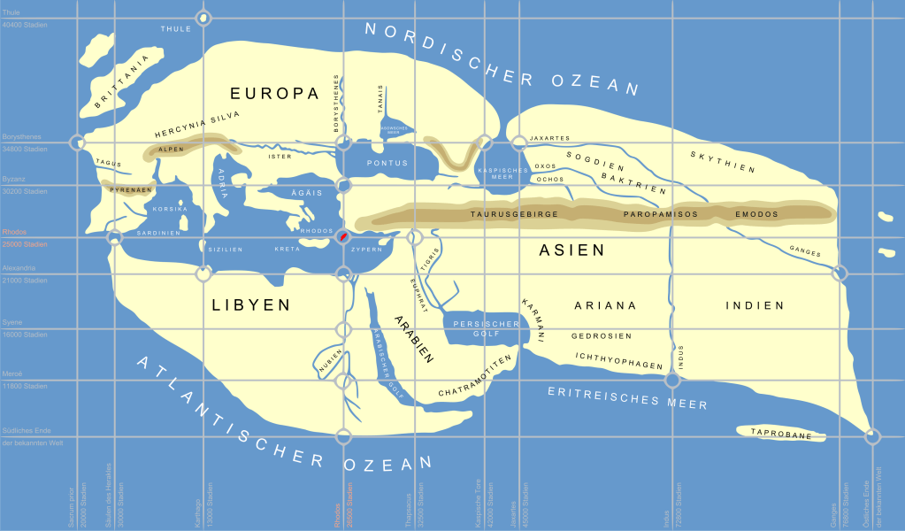
Moving west, in the classical period, we meet the crazy cartographer Eratosthenes, who by 200 BC wanted a perfect mapping of the World. To achieve that, he set about measuring the circumference of the planet, as we have already seen in THE Metre. But once you have the spherical body that the World is, he also exported the concept of dividing the circle and sphere in latitude/longitude to placing specific geographical features of the planet on a coordinate system that has also become universal: the coordinate system of parallels and meridians. With that basic idea, Eratosthenes set about placing every single point on the Earth into a specific coordinate. 2,200 years later we can easily do this feat with the Global Positioning System. The present GPS, though, improves on Eratosthenes and can even measure the displacement of landmasses after an earthquake and the movement of Australia to the north.

Recreation of Eratosthenes’ World map from texts encoding the latitude and longitude coordinates.

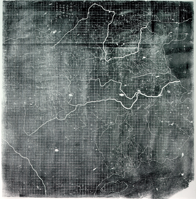
Chinese cartographers had sophisticated mathematical and coordinate traditions of its own. The contrast with the one we have now is that they had different different uses of grids. They divided their maps into rectangular grids, but as far as we know, they did not adapted that grid system to a planetary scale.

The Yu Ji Tu, or Map of the Tracks of Yu Gong, carved into stone in 1137. This map features a graduated scale of 100 li (unit, around 50 km) for each rectangular grid.

Before global oceanic navigation, Chinese, Islamic and European cartographic traditions used coordinate-like systems. Still, the modern coordinate system only became systematically central to global cartography with the onset of global navigation, where Mercator projection of maps that keep consistent meridians and parallels where much more useful to cross oceans than the rule lines that defined the previous Mediterranean navigational charts, the portolans.

The portolans came in the Mediterranean world by the XIII century. A prominent school of Mediterranean navigation charts, called “normal portolan chart” or nautical charts, emerged, and started to be revolutionary in the way that administrations saw themselves, was the onset of the political map.

Originally, the Portolan Chart was limited to the outlines of the coast and the names of the towns and ports along the coast; the interior was left blank, not unlike modern maritime maps. Portolan charts appeared rather suddenly after 1300. They constitute a sharp departure from all earlier maps. The portolan was oriented towards the north and focused on a realistic depiction of geographic distances with a degree of accuracy that is astounding, even by modern standards, which made it a really popular map for navigation. In fact, if we look at it nowadays, we can identify the clearly defined shores of the western Mediterranean, or the whole Mediterranean plus the Black Sea and western Caspian Sea. It is amazing to look at these charts and see how accurate they were.

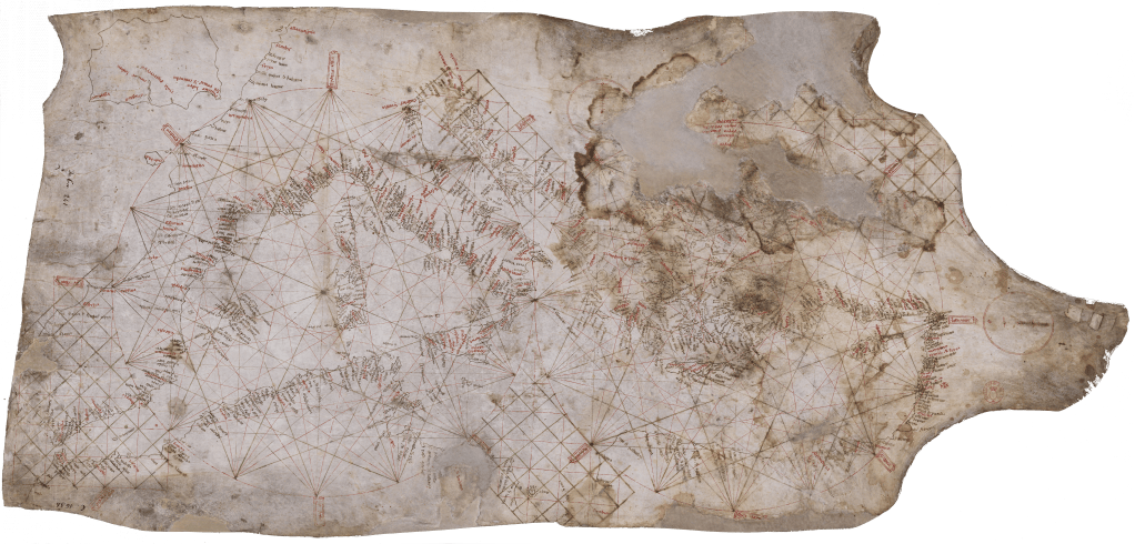
Carta Pisana, one of the few surviving navigational portolan charts. Unlike the much more decorated prestige versions, the nautical ones, which were much more common, did not survive much beyond their heyday, as the Carta Pisana shows in its deterioration in the upper-right corner.

The standard Portolan Chart emerged in Mallorca and north-western Italy (Pisa and Genoa). I would not enter deeply into the story of nautical map-making, and how the Mallorcan one became a standard. But briefly, the dominance of the Mallorcan school had to do with monks, Genoans, Pisans and Arabs compiling previous versions and nautical voyage information. Mostly, the logs of hundreds of ships and how long they took to go from one port to the other. Any single voyage can be biased by winds and the kinds of vessels, but when you integrate thousands of these, all around in the same area, you get quite an accurate description of where each port is situated from each other.

With the conquest of Mallorca, previously in the hands of a small Muslim kingdom, all that knowledge came together in Mallorca, and was primarly handled by Jewish artisans, who produced the most accurate charts. Then, they added some innovations like the compass rose. These charts, then, were widely copied across the Mediterranean. Like today, whoever has access to a large amount of quality data, and knows how to process it, has the advantage.

Interestingly, later in the XIII century, a stylistic divergence started to emerge between the Mallorcan and Italian schools. Italian portolan charts were sparse and restrained, strictly focused on coastal detail, with the inland areas left largely or wholly empty, and the charts largely bereft of illustrations. Mallorcan, meanwhile, developed a variant that contained inland detail and was replete with rich, colourful illustrations, depicting cities, mountain ranges, rivers and miniature people.

What is relevant here is that the Mallorcan nautical charts were of good detail and extra quality. Wealthy clients started asking them to produce more and more sophisticated, embellished ones, covering not only the western Mediterranean, but attempting to draw a World Map, or at least all the known lands stretching to China and Japan.

For that endeavour, they used all the information that they had, be it accurate or sometimes even mythological. When filling these blank inland spaces with all the information that they could gather, the Mallorcans decided to put a plethora of heraldic symbols, shields, and flags, identifying the ruler of each city. These complex creations were not for navigation but for the status of the buyer, and, amusingly, are better preserved than the nautical ones. A clear example of how luxury has a preservation bias.

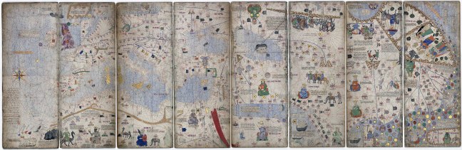
Following this tradition of ellavorate maps, by1370 the Catalano-Aragonese royalty commissioned for the creation of a richly decorated chart that displayed all the knowledge of the World at that moment. This creation is called The Catalan Atlas. We do not know exactly how elaborated Portolans ended up in the hands of the Catalano-Aragonese royalty, but it is not difficult to imagine that they saw versions of Portolan charts and commissioned one to be done richly. Some islands, and cities, had well-assigned symbols printed in a two-dimensional representation of the known World. Moreover, some symbols and notations started to become “standardised”, like painting the sea blue, the Red Sea “red”, mountains as peaks or rounded shapes, and the familiar network of rivers.

What is relevant is the case of the Catalan Athlas, and other similarly rich portolans, is that for some islands, the whole territory was painted with the colours of the flag, in effect covering the whole land. Maybe the monarch asked for the heraldic symbols to be prominent in it, or maybe the author decided that the royals would like the touch.

Full display of the Catalan Atlas showing all the way to China on the far right of the map.

From these covering of island landmasses with flags, I argue that, by covering these islands completely with the heraldic symbol, they started the modern tradition of political maps.

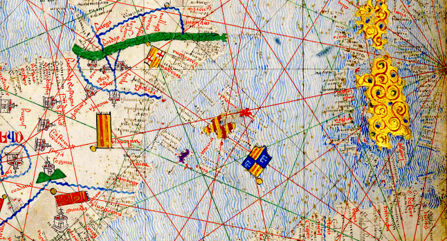
In the case of the Catalan Atlas, the island of Mallorca itself was painted in the colours of the Catalano-Aragonese royal family, four stripes of yellow and red. While Rhodes, by the Anatolian mainland, was painted in the Knights Hospitaller flag, because it was controlled by them at the time.

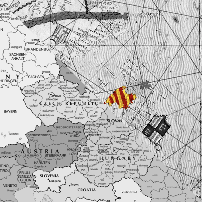
Crop up of the Catalan Atlas highlighting the painting of the island of Mallorca with the Aragonese flag emblem. The islands of Corsica and Sardinia (to the right) are painted in gold to signify their agricultural productivity.

My hypothesis that this painting of Mallorca, and Rhodes, with heraldic colours is the beginning of the modern tradition of political maps might be due to bit of cultural bias. But however it is, the Catalan Atlas is an early example that reached prominence in the European practice of placing your colours into a map to designate territories by the mid-1370s. To be fair, I do not have references on when states put invisible border lines on a map and painted them with a different colour than their neighbours, to signify possession. Probably it is something that more or less was always in the background of the minds and map-making, as the Babylonian map showing the limits and owner of a field already attests.

It is not difficult to imagine how this kind of symbolic, and political, representation could further develop in a contest of who owned more of the parcels of “land” with the flag colours across Europe. In fact, the heir to the Catalano-Aragonese crown gifted the Catalan Atlas to his brother-in-law, the king of France, and it still remains in France.

Moreover, the Catalan Atlas and similar rich maps create the need to fill the “blanks” on the map. Since people wanted these spaces to be “full”, the distant seas of these maps were all covered in miniatures and fake islands. But as knowledge improved, the fictitious islands had to be removed or displaced, and the big pictorial representations on the edges, showing kings and animals, were replaced by “blanks” showing ignorance, the “to come” side, which well aligned with the epoch of exploration by the European merchants, nations and explorers that was coming by the XVI c.

The Europeans kept on developing these two-dimensional representations of the World and, as with the Babylonians, used them to demarcate which land belonged to whom, especially in the case of colonial growth.

This fact of Europeans imposing their World view through maps is well illustrated by the history of how the boundaries and borders of Nepal were drawn. Nepal is one of the few countries in the world that was never directly ruled by a foreign government, though it was not considered an independent state by the British for decades and its foreign affairs were conducted by Britain from 1816 to 1923, although with much more authonomy and independence than the other princely states in British India.

When the British arrived in the subcontinent, they brought with them a European notion of sovereignty, including a novel conception of a nation-state’s boundaries. For the British, and the rest of the European powers, a political boundary was a key feature of a nation-state’s sovereignty: a clearly demarcated line that differentiated between territories. This was as alien to the local (Gorkhali) political tradition as it was to other princely states of the subcontinent, where “boundaries” were fluid constructs defined by physical and geographic features. They were only concerned with the control of villages. That control waxed or waned according to the military strength and vigour of the ruling dynasty.

Nepal’s boundaries were traditionally a fluid affair. Nepalese rule possessed “an unbounded space” that facilitated movements of trade and people. The territorial borders experienced frequent shifts in administration determined by the environment, tribute and taxation claims, which were adjusted year by year, and landholding patterns. Thus, Nepal’s frontiers with the Anglo East India Company oscillated among different agents.

The British viewed borders as fixed and immutable, leading the Company to interpret Nepal’s fluid boundaries as encroachments on British territory. They clearly saw these magical lines on the land that they had seen so many times in their lives.

To better see these lines on the new lands, the East India Company proceeded to survey what they considered the borderlands and fix them in map-making projects. These activities involved carving political and administrative boundaries in Nepal to render the territory “more legible for colonial rule”. These maps served as a strategy for the Company to divide land into non-overlapping, fixed spaces, unlike the traditional shifting and porous Nepali boundaries.

Disputes over territoriality, therefore, constituted a driving cause for the conflict between the Company and Nepal’s fluid borders. By 1813, the British Governor General re-examined the border dispute between Nepal and the Company. Negotiations with the Nepali government to establish a clear boundary soon failed. For example, the Nepalese Commissioners remarked on the futility of debating about a few square miles of territory. About one year later, Britain formally declared war on Nepal. In Britain’s government views, confrontation between the two powers was “necessary and unavoidable”, since there was no clear border.

To solve the protracted war that neither side meaningfully won, but the Company dominated, they signed the Sagauli Treaty (1816). The treaty illustrates how much emphasis the Company put on the detail of the boundaries, for example, stating with extreme detail that “hills eastward of the River Mitchee including the fort and lands of Nagree and the Pass of Nagarcote leading from Morung into the hills“. However, despite the extreme detail, even after the conclusion of the war, the border was not yet settled. The boundary was not defined to the satisfaction of the British until 1830, and still remained a matter of discussion for several years afterwards.

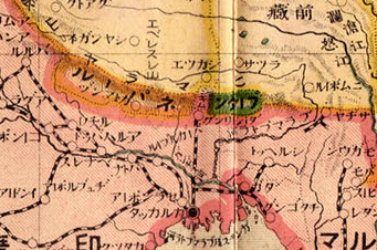
Inset of a 1914 Japanese World map showing Nepal and Bhutan as separate administrative boundaries than British India. By that time other non-European nations already adopted the world view of colouring the surface of the continents in coloured boundaries representing empires and nation-states.

As a result of the war, the treaty took away most of these porous borderlands that Nepal operated with, and a significant part of its pre-war land, like the nominal control of control of the kingdom of Sikkim. Moreover, the Treaty of Sugauli significantly curtailed the independence of Nepal. It was not until 1923 that the British allowed Nepal to fully conduct its foreign policy.

Although political maps were not the only reason for the conflict, the Anglo-Nepali War illustrates how a specific World View of clearly defined boundaries and administrative limits was imposed. Western nations forced, through war and diplomacy, the rest of the World to see the surface of the planet through clearly defined “magical lines” on the land.

As we have seen, other administrations in China, Mesopotamia, South Asia and Mesoamerica, represented territorial jurisdictions and political entities cartographically, however, it is the modern European conception of the sovereign state as a precisely bounded territory became globally dominant through European expansion.

Like English for spoken language, modern political maps are a Western-defined universal language. Now we live in these colourful creations that define how we see the World, and sometimes perversely try to shape that “imagined reality” into the real world, forcing the actual reality of life to adapt to the lens of land, and also seas, covered by neatly delineated lines defining boundaries. This world reality was not common in the World until the Europeans forced it down the throats of everybody else on the planet, by whatever means necessary.

Now we live in this “imagined reality” of nation-states. Now we will see how this reality, this “universal language”, defines how, and who, asks “what does humanity want?”

Previous

Next

The Language of Foreign Affairs

Through aviation and other technical advances, English became the first language to achieve universal and almost exclusive reach throughout the planet in specific niche areas, especially technical ones. English was the first natural language to be dominant in so many technical areas—with the small caveat that chemistry and taxonomy have many technical terms based on Latin. Other than that, no language got that uncontested global dominance.

As we all know, now English dominance does not stop there; the fact that I am writing this text in English despite my mother tongue being Catalan already shows it. If one thinks today of a global language, of an international language, of a World language, the first one that comes to mind is English, and one would have to think hard to come up with others.

Other candidates for World languages could be those which have enough speakers or have had past prestige or dominance. Again, we can think of classical Latin and Greek as playing that role in the Mediterranean and Northern Europe for a while. Similarly, within their respective zones of influence, Phoenician, Aramaic, Persian, Arabic, Sanskrit, written Chinese, Mandarin, Khmer, Malay, Quechua and Maya were, and still are, in similar positions as Latin and Greek. Natural languages that also acted as lingua franca.

Other natural languages have also played a role in the technical landscapes, where vocabulary from the language extended far beyond the natural geographical area by giving names to specific technical features. Before WWII, if one wanted to follow the advancement of science as it progressed, it was necessary to be a versed reader in, at least, French, German and English. This is because during the early phases of the industrialisation of Europe these three centres had comparable influence in the creation and propagation of scientific and technological advances. At the time, no one language dominated over the others, even in the small niche world of science and technology. As we have seen, this shared dominance changed with the appearance of new technologies —like aviation and software—that took off especially during the war years and soon afterwards. Maybe there was the little exception of Russian being used for advanced mathematics, theoretical physics, nuclear physics, rocketry and other highly technical and specialised fields, as a heavy amount of research was done in these areas during Soviet times. During the Cold War years it would help to know Russian if one wanted to keep up with the times. Yet, that time for Russian also ended after the collapse of the Soviet Union.

By the mid-XX c. and especially in the XXI c. English has become the default natural language of the World, with no competitor even close to it in terms of reach, number of second-language speakers and its use in many different fields of international reach—from international law to the language of memes. English has influence in culture, the arts, travel, sports, economics, food, science, technology, romance, infrastructure… Probably there is no area in the world that it has not touched in one way or the other, with maybe the exception of really local traditions that have escaped the reach of anthropologists, missionaries or travellers. Each of these does codify the World in the international language by default, English, or they translate to English whatever was captured in another language.

English is the default natural language to approach virtually any aspect of life when one thinks in international or global reach. It is so much so that when I was travelling in Vietnam, I remember the locals talked to me in “foreign language” because they needed to practise with me their “foreign language” skills. For them English was not just a language, but the language that dominated “foreign” relations and affairs, that is, whatever was of international matters. I, as a traveller from afar, was not expected to have as my working language my own Catalan, but just the default language from “foreign lands”. It was not even called English. It had nothing to do with the origin of a kingdom on a small island off the coast of north-western Europe. It was just The Language of Foreign Affairs. That was not just in Vietnam, but I also heard that expression in many other Asian countries. In these nations, any foreigner was expected to be fluent in that “foreign language”. That expectation would not have been so just 100 years ago. At that time Western Europeans and Russia dominated the planet, but there was a bunch of languages that would have been expected to be known by a traveller. Moreover, if the traveller had scientific training, that person would be expected to be familiar with German, French, English and also Russian. And depending on which part of the world you were, most travellers would know Arabic, Persian, Mandarin and Malay, Spanish and Portuguese.

That dozen of “foreign” dominant languages has slimmed down to just one on the podium. English. The first natural language to hold that position alone, and so far, keep it.

Curiously enough, the English language is a kind of “lingua franca” by itself, with some linguists considering it a “mixed language”, creole or pidgin as 29% of its vocabulary is of French origin, 29% Latin, 26% Germanic, and verbs are inflected for tense and number but not for person. Others say otherwise and argue that it is in fact a Koiné language (the simplification of different dialectal forms in contact). But this is mostly a debate of definitions, on how to divide a continuum. This kind of division of a continuum, and the Sorites Paradox, is something we will explore in the future related to what does humanity want.

However English is defined, for whoever has to learn English for the first time, they soon discover that English is quite simple grammatically. It has no gender, only a handful of irregular verbs and most of the vocabulary is quite simple, with many words composed of pairs of others like “water-fall” to designate something that in many other languages has a proper word, like “cascada” used in many Latin languages. And the fact that cascade also exists in English shows another sign of “lingua franca”, that is, of vocabulary emerging from many different origins and backgrounds.

In fact, this mixture comes as no surprise when one knows a bit of the history of the English kingdom.

It was a Roman province thinly controlled by a military elite which was depleted over the dwindling of the Western Roman Empire. The Celtic population there only partially adopted Latin as their vehicular language, and with the power void left by the absence of the Roman legions, other peoples took the opportunity to fill the power vacuum.

Then came the Anglo-Saxons, from present-day northern Germany and southern Denmark. The Angles have left the name to the country and the Saxons many elements of a Germanic language, built upon strata of Celtic and Latin.

After them came the Norse, another Germanic language from northern Denmark and Norway, which contributed to much of the vocabulary like they, them, their. Also, the interaction between two similar but distinct varieties of Germanic languages contributed to the koinezitation of the Germanic variants. It produced a simplification towards a common grammar, which departed from Old English by greatly reducing the inflectional system which was not shared between them. This simplification, for the happiness of many students of English, increased the amount of regular verbs present, and got away with the almost nightmarish inflection systems that haunt the students of German.

Then, soon afterwards came the Normans, who brought with them French. The aristocracy took over what is now England and they brought with them most of the vocabulary that comes from Latin and can be found in modern English, like the word cascade. The Norman aristocracy left much of the vocabulary on the topics related to the elites, including cuisine, where most of the vocabulary comes from French and Latin, like the word cuisine itself. That makes it easy for us Latin speakers to learn the language—once we learn how crazily the English speakers pronounce our words…

Unfortunately, all is not that easy. At some point by the XV c., someone decided to standardise the written form of English. They adopted the way they spoke at the time, what is called “Middle English”. Middle English and Modern English are quite similar in most aspects, but, unfortunately for us, especially if you are dyslexic like me, the main difference is that the whole southern population decided to change the way they pronounced words. That change is known with the grand name of the “Great Vowel Shift”, which affected mainly vowels and diphthongs’ pronunciation, but also how some consonants became silent. This has left us with the horrible challenge of having to remember by heart how words like bite are spelled, because the correspondence with the actual pronunciation bait is low or nonexistent in many cases.

Moreover, the printing press did a small mess. As we have seen with the standardisation of punctuation, early on, spelling standardisation of printed English happened mostly outside England. Books in English were printed mostly in the nearby Netherlands and Germany, as they had a more developed industry. The typesetters, not being profoundly familiar with English, would adapt German or Dutch spellings to write English words, like adding an h to “ghost”, from the Dutch gheest.

To complicate things further, English nerd writers who thought themselves to have command of classical Greek and Latin tried to reinforce supposed Greco-Latin origins of English words. They happily started adding silent letters to reinforce the real—or imagined—links. For example, dout became doubt (to link it to Latin dubitare), and funnily, iland became island because they convinced themselves that the word came from Latin insula and not from ieg-land, from Old English meaning “water land”.

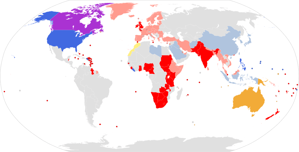
British (red) and US (blue) spelling of the English language.

The current spelling differences between US and British variants come from dictionary initiatives. English is, famously, a language without an institution in charge of standardising and leading change, unlike neighbouring ones like Spanish and French. In the US, a few decades after its independence, the Webster dictionary (1828) got established as the leading reference for spellings and introduced the simplification of words that used to be written with OU and were shortened to O, like color and neighbor. Z replaced S in many endings of words, like analyze and customize, because of Greek roots and is more phonetic. LL was reduced to L in words like metallic and modelling. Meanwhile, British English kept following Johnson’s A Dictionary of the English Language (1755).

Finally, an intriguing attempt at spelling rationalisation came in the saga of the “simplified spelling” movement for US English. The notion here was to scrub English of silent letters and irregular vowel pronunciations, so that have would become hav in a simplified written language. Leading the charge was Melville Dewey, creator of the Dewey Decimal System (oh, you do not know about it? You can guess why, another triumph of standardisation). Melville hilariously demonstrated his commitment to the cause of “simplified spelling” by legally changing his name to Melvil Dui. Dui got his funding from a wealthy donor by 1905, and simplified spelling won support at one point from President Teddy Roosevelt, who tried to instaurate it as the governmental spelling through an executive order. It did not work. The wealthy donor pulled his funding by 1915 with a poignantly spelled note: “I hav been patient long enuf.”

Nevertheless, however easy English is—because of its emergence from a combination of mainly three different linguistic backgrounds—, and however difficult it is—because of the standardisation of it in written form before the Great Vowel Shift and two slightly different standards—, English has become the first natural language to be the dominant and almost universal language of the World. The default cannon, the standard way of communication, the accepted-upon general channel of exchange, the platform upon which to create the connections between different places and peoples of the planet.

English, now, is a truly global codex that, for the first time, has reached and is reaching all aspects of life all around the planet in a way that no other language has ever done on such a scale, depth and speed. A natural language that, like any other language, has adapted, evolved, shifted, transformed, grown, reached new frontiers because of the necessities demanded by its new global role and new global users.

Notwithstanding, the global reach of English and the Anglo-Saxon culture behind it, its dominance happened simply because it has been an opportunistic being that has piggybacked on the extreme connectivity that the planet has taken, starting with the shipping revolution.

Like with Austronesian, the maritime revolution brought a handful of languages to dominate specific locations. But unlike previous connectivity expansion, the new aeronautical and computational revolutions have placed English as the unique global channel of communication.

History could have provided a different outcome, where, like the scientific world before WWII, global communication was shared by a handful of languages. If, like naval powers, different cultures and states reached a similar technological point at a similar rate, other languages might be sitting together for global communication. For example, in aviation the French had an early start with plane-making, and by WWII Germans and Italians had quite advanced military development on planes. Similarly, Polish and German scientists and technicians had early advances in computation, and the USSR and Japan could have invested more in electronics, software development and computation, but never got around to that. It is conceivable that another order could have happened in which a part of the planet rejected the English standard. In fact, that can be partially seen in countries like North Korea, where they firmly reject anything that has hints of Western culture. But nevertheless, even North Korea follows the aviation and software defaults. For better or worse, English stands as a giant alone in the human world.

For this text the fact is that, for now, there is a global acceptance for English to be the default language of communication. That fact, however it is, gives us a tool to address our question, with its usefulness and limits.

In a way, the question of “what humanity wants” can be asked because we, for the first time, can talk in the same language, and it has done so in a somehow passive way, like other standards such as timekeeping. There is not a chunk of the world that is disconnected from that acceptance of the default, there is no major iron curtain that keeps two or more disconnected systems. Since “humanity” has accepted this language, that has allowed English to permeate all the spheres needed for global communication.

Previous

Next

Programming languages

One sector that has reached most of the world’s people, and that also has a highly technical sector supporting it and fluent in one natural language, is informatics or Information technology (IT for short). If you are reading this text it is because of IT. It has been written down in a computer, sent to a publisher through the Internet where it has navigated different servers. Then again processed in another set of computers, and sent to your screen. This is still text, and it could have been done all like in pre-electronics time, but the difficulty of that would have been much bigger, as society is not familiar with the old ways, and the infrastructure is no longer in place to produce this kind of work in an accessible way.

Informatics is ubiquitous all around us, probably even your washing machine might have some pieces of code into it. Internally many electronic devices run using a specific language which is called “software”, a set of instructions written in a programming language which translates instructions that can be understood by humans to instructions that can be understood by the machine. That “language” is a set of instructions based on another natural language, English, the same one as aviation.

You can check this out quite easily, if you go to an internet browser based on open-sourced technology, such as Opera and Firefox, right-click on any web page and select the option “source code of the page”, or “origin of the page” or something along these lines. If you select that option you will see a long list of strange text. These are the instructions, the “programming language” will be a mixture of HTML and Java Script, and no matter where you are, virtually all of the keywords that you would see in that text will be “if”, “for”, “script”, “function”, “window”, “style”… All of them English vocabulary. Any computer in the world would use them and virtually all widely used programming languages are equally based on instructions that make use of English words such as “do”, “while” “end”… If one wants to program one would need at least a basic understanding of the natural language that is English.

This process of English coding itself into the infrastructure of IT happened for similar reasons to those of aviation. After World War II, a German scientist had already developed the first programming language, Plankalkül. But with the development of electronics moving to the US, and the Soviets not picking it up from this lonely German, the Plankalkül did not have much influence in the languages to come.

In the US in particular there was a heavy investment in all the IT sector by the US industrial might and wider university sector in UK and US. That effort set the backbone of all the programming languages to come. All of them were trying to make it easy for programmers to translate the instructions to the machine, and of course, for them English was the easiest language to use. Therefore, the syntax of the languages, by default, was in English. As with aviation, this was the first time that a prevailing technology was developed by only one linguistic group. The technology took global scale thanks to the level of connectivity developed since the years of the navigation breakthroughs. The English-speaking world piggybacked on the networks already established. With the redefining of world equilibria after WWII, English achieved almost total dominance in two key aspects of our current world, Aviation and IT.

To put this in context, there exist now about 8,500 different programming languages, all of them developed in the last 70 years, and virtually all of them with some amount of English in its structure. For comparison, that is more than the total of natural languages surviving on the planet today, about 7,000. These spoken languages took thousands of years to develop, and most of their diversity remains in only one island, Papua, where about 1,500 exist.

What is more interesting from this is why the Soviets, or the rest of the powers for that matter, were not able to muscle out alternative systems. As we have seen previously, the Europeans took over almost the complete surface of the planet. By the end of WWII the only territories that had some influence over the rest of the world were the US, the UK and the USSR. UK and US had English as their language, which translated to their technology. The USSR had Russian as its main language, so did they develop a programming language based in Russian and the Cyrillic alphabet?

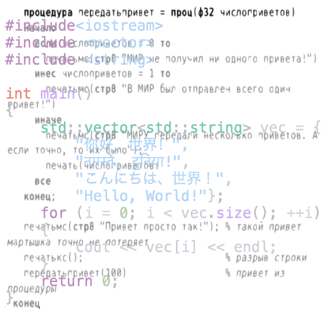
The answer is that they did, but with few exceptions, did not continue the effort. By 1959, in Minsk, they developed a computer that used assembly language (strong correspondence between the instructions and the specific architecture of the computer), and later auto-programming systems translators — “Autocode Inzhener” and “Autocode Economist. It also incorporated translated languages such as ALGOL, ALGAMS and FORTRAN, which were developed in English logic. Meanwhile, in 1965 they developed a computer called MIR, not to be confused with the MIR space station. МИР (MIR) means both “world” and “peace” in Russian. The computer used AлМИР-65 (Almir-65) as coding language.

However, that incipient development did not come to foster further independent development. By 1966, when the Soviet Union could have had some influence in the wider world, the US and themselves stopped it. For example, when the Soviets signed a cooperation agreement with France to share IT research, the US punished France by blocking the purchasing of US mainframes, the supercomputers of the time. That might have been the pivotal moment for two independent computing systems. By 1968, the Council for Mutual Economic Assistance, an umbrella for Soviet-aligned communist and socialist countries –China already broke relations with the CCCP by that time– it was decided to abandon the Minsk line of computers, despite being on a par with its western counterparts, because it was decided that the software development was much more advanced on the other side of the Iron Curtain. Thus, the strategy shifted to develop a series of mainframe computers compatible with IBM’s System/360-370, as all the code could be more easily imported. The hardware was created by reverse engineering, but the software, the code, was based on IBM’s. From then on, the scientists and engineers were ordered more and more to copy semiconductor designs, playing always a catch-up dynamic which did not provide much room for fostering, and keeping, independent systems. By the 70s, the Soviet government ended most of the independent development, encouraging the pirating of US systems, and then by the mid-70s the US started exporting directly the computer hardware to the Soviet sphere.

And we all know what happened by the 80s… Through computing one can easily see the slow, and then fast, train of Soviet crash. With Perestroika, the Soviet bloc increasingly adopted foreign computers, but they were relatively more expensive. As the system was collapsing, the West pressured the Soviet government to grant exit visas to computer experts. By the fall of the CCCP at the end of 1991 the large state companies that manufactured computers for the Soviet military virtually ceased to exist.

With that rapid collapse, any real hopes for an alternative, non-English syntax system, mostly banished, with only a few strongholds. One is РЕФАЛ language that originated from the time that alternative system might have seemed possible (1966-68), and still is in use today, albeit also with English syntax. РЕФАЛ (Refal) is oriented toward symbolic computations, meaning that is good for mathematical and theoretical development, but also for writing sophisticated computer programs. These characteristics make it useful for some niche applications like text processing, language translation, artificial intelligence, but is not widely used and was not widely adapted for the Soviet mainframes. Another stronghold was Elbrus, a family of computers starting in 1972 and used in the space programme, nuclear weapons research, and defence. They initially used the Эль-76 (Elb-76) programming language, based on Russian syntax, but also used ALGOL, which is English-derived. Moreover, by 1978, Elbrus implemented a processor that executes instructions in an order depending on the availability of input data and execution units, independently of the actual order in the program, with register renaming and speculative execution that was years ahead of Western counterparts. Since Elbrus was linked to the military and space sectors, which were partially kept afloat in Russia by the West to keep a bit of the military and space capacity in place, that niche system had some options to persist.

For the rest, the Soviet system did not provide an alternative architecture to the Anglo one, not even in revolutionary terms, like the French with their Metric system, which persisted despite the first French Republic, and first French Empire burned to ashes in the Napoleonic flames. That universal role, in coding, has been left uncontested, so far, to English.

Previous

Next

Aviation, One language to rule them all

From roads let us go to the next technology in transport, the sky!

But first let us briefly return to our beloved Metric as an example of how the institutionalisation of technical terms has changed how most of the people on the planet see themselves. For example, the metric is even applied to such delicate aspects of our life as how much our newborn baby weighs.

So if the Metric is so intertwined in our everyday lives, it is interesting to look at one of the first and most powerful real universalisations that actually does not use the metric: aviation. For anybody familiar with planes, they will notice that many of the indications of flight control, altitude, distances, meteorological information and other measures are in what is called the Imperial system. I.e. in feet, knots, miles etc.

Aviation, like road traffic, greatly benefits from a common universal language, and in this case it has achieved it. As with the other nascent scientifico-technical internationalisations, aviation’s global language arises hand in hand with the rapid growth and usage of the new technology, and now the neighbours are not just overland but also over air. Therefore, as with the telegraph, the previously semi-disconnected UK and US administrations are much more susceptible to fold into common standards with the rest of the western world, or in this case, to impose them.

Little more than 100 years ago, almost nobody had ever flown. Thirty years later planes were used to bomb and burn entire cities, like in the case of Guernica, sadly the most noticeable example of the use of the new aerial technology aimed at the destruction of civilian life. A decade later, after WWII, planes were routinely crossing the Atlantic. That rapid expansion needed close collaboration to manage these vehicles across multiple lands and cultural codes. No one would want to have signalling that would confound the pilots or the machine maintenance because different protocols were used in each of the landing areas, nasty results ahead otherwise.

In the early beginnings of cross-Atlantic flight, six nations grouped to divide the Atlantic into ten zones. Each zone had a letter representing that zone, and a station providing radio relay, radio navigation beacons, weather reports and rescue alerts if an aircraft went down.

To coordinate the radio signals, administrations had to agree to common protocols, technologies, radio frequencies, languages, measures and so on and so forth. That was the beginning of international flight.

Since we jumped to after WWII, the United Nations is already up and running (we will deal in detail with the UN in later sections). Therefore, it fell into the hands of the UN to set up an agency organising all the protocols and regulations of air flight: the International Civil Aviation Organization (ICAO). The ICAO has virtually universal participation (192 out of 193 nations in the UN — only Liechtenstein is out, as it lacks an international airport, but so does the puny Monaco and that does not stop it from being an ICAO member). Then, because, well, virtually everything else in the world was in Metric at the time, the ICAO’s guidelines recommended that the needed units to coordinate flight be based on the metric system.

They failed.

The fact that aviation is in Imperial lies down to the usual suspects, the US and the UK. In the basic framework that we set, technology, independent administrations and colonialism, aviation is a good example of the first-mover advantage of a big administration. A big part of the aviation sector was established in the US, especially at the moment that aviation became really international, just with the onset of WWII. From that moment, inertia took over, and whatever units the dominant player was using, these became the ones to be kept, until now. The US and UK never forced their hands. In this case, the standard just became and now in planes you find this:

  • Feet for height
  • Knots for airspeed (Nautical Miles/Hour)
  • Nautical Miles or feet for distance
  • Statute Miles or feet for weather (visibility and Runway Visual Range)
  • Inches of Mercury for altimeter settings
  • Pounds/square inch for pressure
  • Pounds for the fuel quantity on the aircraft
  • Pounds/hour for fuel flow
  • Gallons to order/purchase fuel

But, wait, what about the Cold War, how did the Soviet bloc adopt an “imperial” system? you might ask. You did well to ask, the aviation sector of the former USSR republics, North Korea and China. However, Russia changed their system to imperial in 2017 for practical purposes of internationalisation, showing how inertia can hamper or shift standardisation – we will talk about inertia and its relevance in the human world later on.

The aviation system is a good example of how things work on the drive to universalisation. Again, it is a technology linked with a global connectivity which forces the policymaking institutions and a highly technical sector to agree to a common understanding. Here geographical extension, technique, technology, communication, policies and standards go hand in hand to establish a more or less established global agreement, with the limits of inertia and the fight between two standards, the traditional one (Imperial) and the scientifico-technical one (Metric).

Nevertheless, the universal I want to focus on for aviation is another, its language for communication, where a natural language (although highly technified) took over. Only one spoken and written language is used in the sector, that language is known by everybody in aviation. That is a global spoken language.

My father once told me that English was in the past a planetary language because all in aviation used English. The moment that English was adopted in aviation might be the first time that a language is truly universal among one specific sector: traffic controllers and all pilots who fly internationally. In the aviation case we have the bases of a natural language becoming a global phenomenon, although circumscribed to a really technical sector. In this case, though, for the first time there were no local variations or the connivance of two or more standards. One language to rule them all.

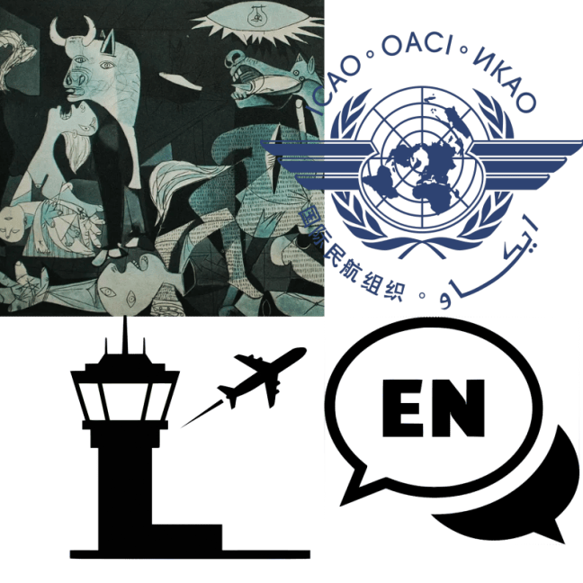
In the same way that the Imperial system is the dominant (but not exclusive) measurement system in aviation, English became the dominant and exclusive language in aviation, despite what the ICAO logo at the beginning of this entry shows.

Nevertheless, the language, despite being a natural language, was limited to professional usage. I do not see the air traffic controllers writing poetry based on the level of English that they need for their work. In fact it is a kind of technical language: adverse yaw, downwash, squawk… are mostly obscure for anybody using English but not working in the aeronautic sector.

In the case of aviation, like the signage for cars, the need for a common universal language arises from the rapid growth and usage of a new technology, and administrations doing what administrations do best: administer.

The process of embracing a unified rule code has had slightly more success than the Vienna Convention for road signs. Aviation has achieved not only the existence of ICAO with virtually universal participation, but also the language of communication in the aeronautic sector, that is, the spoken and written language is only one and has to be known by anybody working in the sector. Now, at a planetary scale a single language is uniquely present in the sector.

Like we have seen before, the aviation system presents the process of universalisation through technical development, administrative interaction and imperialism. Again, aviation is a technology linked with a global connectivity which forces the policymaking institutions and a highly technical sector to agree to a common understanding. Here geographical extension, technique, technology, communication, policies and standards go hand in hand to establish a global agreement. Impressively though, in the aviation case tradition is the one that has kept the two technical standards (Imperial and Metric), but has, for the first time, erased natural language diversity. Aviation = English globally.

We have the emergence of a natural language becoming a global phenomenon. We will see the limits of natural languages becoming the vehicular communication of technical or niche sectors, but for now we have seen that aviation was the first, or one of the first, sectors to break the crystal ceiling of a unique global language taking over one piece of the world. Aviation has increased the connectivity of the planet and has made accessible and affordable rapid travelling times for a huge chunk of the world’s population. However, it has not yet reached the vast majority of the population.

For now, I leave you with the fact that, for as long as humanity has existed, English now constitutes the first truly, and unique, global language that has relatively easy access for learning and use, from technical to everything else. If the metric is used for something so tender as the weight of a newborn baby, imagine what a whole language is doing, and will do, to us.

Previous

Next

Roads: rules and signs

Let’s leave bureaus, sports, aid and law for a bit, and focus on one more scientifico-technical standard that emerged on the back of technological development at the beginning of the XXc.

The world had not finished with mathematics, music and signs as technical or symbolic languages. A much more passionate topic rolls on: road signage!

As with clocks (timekeeping), religion and administration (the calendar), accounting (mathematical signs), the printing press (punctuation), musical instruments (music sheets), geodesics and administration (the metric), statistics (significance and error conventions), the telegraph (the Morse code), the World Fairs (places for technonerds to meet), the railways (time zones), bicycles (standardised parts) and typewriting (QWERTY keyboards), the motorised vehicles that were taking over the planet at the beginning of the XXc were poised to push some convention upon us.

We might be familiar with the signs that emerge on the side of roads. They might be circular, squares, triangles, octagons, or sideways squares (diamonds), shields and house-like shapes (pentagons). Their colours would be red, white, blue, yellow, green, with the occasional brown, pink, or orange. There are also luminescent ones, with colours that change, usually from green to orange and to red. These signs have a combination of standardised pictures, messages and numbers to convey an almost global meaning. These signs are expected to be understood by the people who go about on the roads with their motor vehicles.

The signs and traffic lights did not exist before the clogging of the pre-existing roads with these fast vehicles, though bicycle clubs were the first ones to experiment with road signage, especially indicating slopes. The new road conditions called for easily identifiable signs to be read quickly by any driver, no matter their origin. So, with the fast, and numerous, vehicles the signs went up. Soon enough people in Europe were aware that the signs had to be shared across national borders, otherwise vehicles crossing from one country to another could be confused by different meanings. Speed of reaction was, and still is, crucial.

Following the international conventions that we have seen emerging from the end of the XIXc. on the back of technical inventions and imperial powers, they organised what probably is one of the most boring conferences in history. In 1909 the European vehicle associations met in Paris to decide on a small set of common traffic signs. They did a similar thing in 1931 and 1949 in Geneva to unify a larger set of signs on a European scale. By 1968 security triumphed over boredom, they met in Vienna and created the “Vienna Convention on Road Signs and Signals”, aiming to make traffic signalling universal for the whole planet.

They failed.

Map of "danger" sing shapes on by country. Red, blues, green denote triangles use  ad warning or danger. Yellow and orange indicate diamonds use. Purple has both.
Map of “danger” sing shapes on by country. Red, blues, green denote triangles use ad warning or danger. Yellow and orange indicate diamonds use. Purple has both.

Currently, there are two main road sign standards on the planet, plus a lot of other stuff in between. One of them is the European one, which gave the world the “Vienna Convention”, adopted by 68 countries (roughly red on the map), and the North American one, boringly called the “Manual on Uniform Traffic Control Devices for Streets and Highways” (MUTCDSH), and used, with many variants, in the yellow countries on the map. But not all is well and standard in the US for the MUTCDSH, as some states engaged in Typefacewars, maybe the most bland wars in history. In southern Africa, ten countries use the also engaging name of the Southern African Development Community – Road Traffic Signs Manual (SADC-RTSM).

Road traffic sign from South Africa, as encoded in the Southern African Development Community – Road Traffic Signs Manual

But even in MUTCDSH- and SADC-RTSM-derived countries, The Convention forms the basis of much of the traffic signage, or is similar enough. If a non-Irish European drives through the US, most of the signs would be immediately familiar. The biggest differences between The Convention and Non-Convention countries are that speed limits and obligatory signs are rectangular, and yellow diamonds with black signs are used as warnings. Instead, The Convention uses round signs for speed limits and obligatory signs and an upward-pointing red and white triangle for warnings — also shared by SADC-RTSM, but one might find different animals. Even that difference between Convention and Non-Convention danger signs is not much, as an upward-pointing triangle is just the upper half of a diamond, therefore it is not much of a stretch of the imagination to understand the other.

The story of road signage does not stop in the 20th century! In 2025, the Global Forum for Road Traffic Safety (another global boring organism that rules your life but you probably never heard about) passed a resolution to replace the entire text of the Convention! The exciting road-signage path rolls ahead!

We then took this little traffic diversion to show three ingredients that we will see from now on shaping many of the global questions of the planet. First, an agglomeration of big and middle-sized countries that are in close proximity to each other and need to share a convention for the benefit of them all find terms to agree with each other. Second, when new technology standards — especially related to communication — emerge and extend, the consolidation into commonly agreed rules tends to take shape relatively fast. Third, colonial powers force the conventions into colonised territories without the input of the societies under dominion.

Roads, moreover, are the paramount example of infrastructure. It is needed, inherited, maintained over generations and represents connectivity like nothing else. For much of the modern world, the combination of technology and infrastructure drives the need for a — virtually — universal language. Coordination forces create the political motivation for neighbouring, independent administrations to sit down at a table and try to agree on a common set of conventions. Once a standard achieves enough maturity through this process of regional standardisation, technological development and colonial imposition, the parts of the planet that are still not part of this dynamic are more likely simply to adopt that standard. New players, then, either adopt it or at least have it in consideration.

With these three characteristics, it is easy to see how Europe is the place in the World that has the most influence in shaping much of the standards and internationalisation, as we have seen in the Western Dominions entry.

Similarly, exceptions to these three general trends are easy to see, with densely populated islands that have not been colonised recently, like the Japanese archipelago and Great Britain, and big countries like China and the US. The US and the UK in part explain the survival of two Western standard flavours, as they were big enough, isolated enough and innovative enough to consolidate and protect their own conventions, but still share much with the rest of international protocols.

This kind of mindset and framework would be important for our question of what humanity wants.

Previous

Next

International organisations

With the metric system we have seen the emergence of the first international organisations, with the Metric Convention being established in 1875. This came in parallel to the establishment of the Internationale Erdmessung (Association Geodésique Internationale), which was established in 1886, but traces its roots to the Mitteleuropäische Gradmessung (Central European Arc Measurement) in 1862.

Checkmate

But before that we need to go back to London’s 1851 Great Exhibition. Similarly to how scientists used the excuse to meet and set off meetings and gatherings to improve measurement, London’s chess community felt obliged to do something similar for chess. A good question hanging in the air is, “what happened with other communities, like dancers, sports, card games, medics, lawyers, botanists, etc.?”. Maybe these did gather, but unlike the tech and chess nerds, not much continuity happened. It also helped that chess players were often older gentlemen with relatively easy access to resources to play their pastime. Compared to physical sports, this is my speculation, people at the time had little tolerance for sweaty youngsters.

In the case of chess, they might have felt inclined to organise a chess congress because, by that time, chess rules had been mostly standardised, but needed a final international agreement to complete the standardisation of the moves, chess notation, and agree to time limits to avoid “out-sitting” opponents. Even the design of the pieces stabilised around the Staunton chess set by 1849. Moreover, there were European and transatlantic antecedents of gathering to play chess against each other, like in 1834 in London and 1843 in Paris. However, the London organisers considered that there would not be time for a single “Chess Parliament” session to handle both a competition and the standardisation process, so it was expected that a series of Chess congresses could address the normative issues.

After the London Chess Congress event, more tournaments were organised in 58, 62, 66, 70, 72, 73, 78, 82 and 83. After that, a tradition emerged of a world champion being decided by a match between the reigning champion and a challenger. When a challenger was identified, financial backing would be raised for a match or tournament.

After the first world tournament held officially in that format in 1886, by 1887 the American Chess Congress started work on drawing up regulations for the future conduct of world championship contests. These were not standardised until the 1940s, though, and changed several times after.

However, a unified governing body of world chess did not materialise until 1920, so the universalisation of rules and gatherings emerged as a bottom-up convergence and willingness to gather, compete and galvanise an international bulging community of chess nerds, ehem, aficionados who could meet on the back of the interconnectedness of the technical world, steamships and railroads to budge heads against each other.

bep, bep, bep, beeeeeep, beeeeeep, beeeeeep, bep, bep, bep

Let’s now focus on that interconnectedness by looking this time at one of the earliest emergences of governance of information sharing through a new, and now vanishing, technology, the humble telegraph. We already introduced the telegraph as the fragile electronic transcontinental communication by 1858 in the [section fragile communication] where cables were laid, and lasted for weeks, then years.

Again, the German-speaking states led the way in homogenisation of standards and creating a bureau to handle the telegraphic connection and telecommunication between states.

Following the interconnection with railroads, the Prussians and Austrians connected Berlin and Vienna with a telegraph by 1849, along the railroad that connected them. They formalised the connection by a treaty ruling the “installation and use of electromagnetic telegraphs for the exchange of international dispatches.” By 1850, Prussia signed agreements with Saxony and Bavaria. Boringly, this followed similar agreements for mail exchange. Treaties simply aimed to control the flow of messages and the procedures for exchanging them at national borders, as well as the application of tariffs.

However, these treaties were the basis of the Austro-German Telegraph Union (AGTU), which was established on 25 July 1850 in Dresden. Unlike mail, telegraphy was a new and constantly evolving medium; therefore, the AGTU should organise periodic telegraph conferences to review and revise treaties, such as pricing. By 1857, with the addition of new German states, the individual treaties were unified into one in the Stuttgart Convention.

Finally, membership of the AGTU was made available to other countries, even non-German ones, and to some private companies. The Kingdom of Lombardy-Venetia, the Netherlands, the Duchies of Modena and Parma, Tuscany, and the Papal States also joined the AGTU, despite not being Austro-German. In 1852 Belgium, France and Prussia met in Paris to agree on standardised conventions.

However, French being French, they had to create their own system. In late 1855, in Paris, they founded the West European Telegraph Union (WETU), together with Belgium, the Kingdom of Sardinia, and Switzerland. The WETU also admitted other countries and private companies, some of them laying submarine telegraph cables to Britain (by 1850)! Portugal, the Netherlands, the Grand Duchy of Tuscany, the Duchies of Modena and Parma, the Papal States, and the Kingdom of the Two Sicilies joined. Notice that the Netherlands and the Papal States joined the two separate unions. During the 1850s, there was a gradual process of convergence and overlapping of the two unions’ activities and conventions.

Since many of the states were already intermingled these two organisations, they needed to merge them one way or the other. In 1858 the Brussels Convention created pan-European conventions. The conventions stablished conventions i.e. standards. Yes, not the most clear language, but that is how one end up with multiple standards. But for they credit, by 1859 the two organisations aligned almost all their provisions through, you-know-what, a new convention! The Berne one this time.

Having three almost equal, but not consistent, conventions made routing of telegrams a bit of hair-splitting sometimes. By 1861 most European countries, and even Algeria, had joined the Brussels one (all but Britain, who had private telegraph networks).

The rapid growth of the new technology and its use needed standardisation. By 1865, soon after the arc-measurement, the European countries met in Paris at the auspices of the lesser-known Napoleon, Napoleon III, to deal with the emerging electronic telecommunication. The participants dropped the Austro-German and Western European parts to create the International Telegraph Union (ITU), mostly based on the initial austor-german conventions, but making them a consistent set among all participants. In a joke of destiny, the end of the lesser-known and ill-tempered emperor Napoleon came from a redacted, ill-interpreted telegram five years later. We all know that texting and emotions are not easy. Telegrams were the texting of the 19th century. Had they stuck to letters, we do not know how history would have been.

Since the texts had to be codified across languages and borders, but most countries used the Latin alphabet, they adopted the Morse code and its instruments as the standard to represent letters. Interestingly, the code had been developed on another continent, America, by Samuel Morse in 1844 in the US. For Russia and other eastern European regions, Cyrillic had an equivalent in Morse code, developed by 1856. If you are curious about non-alphabetic Morse codes, the Chinese one is quite interesting.

For the first time, regulations, tariffs, and technology were harmonised across all of Europe, as far as its borders with Africa and Asia. Three years later, in 1868, the second International Telegraph Conference was held in Vienna. It focused on technical and administrative issues, rather than diplomacy. Significantly, the conference established a permanent ITU Bureau in Berne.

I’m telling the story of the ITU in some detail because, like the metric system, it represents one of the first international institutions to emerge from the technical, scientific and map-making needs of industrialists, commercial interests and states.

In this case, bilateral agreements that looked much like each other quickly expanded into a multilateral agreement and the creation of an international bureau. The rapid development was spearheaded and pushed by the rapid expansion of the new technologies and methods that benefited from standardisation and homogenisation across the world.

The beginning of this section is the code for SOS in radiotelegraphs, established in 1905 by the Germans as simply being three short beeps, three long ones, and three short ones for ships, just for easy identification and memorability. The equivalent Morse letters being S, O, S, which gave the informal name for oral memorability. Better say SOS than three dots / three dashes / three dots, frankly…

The code was used for distress signals for ships at sea, and later extended for distress calling in general, aimed at a natural human willingness to help other beings in distress. We can look at that natural willingness, which is commonly called humanitarianism, and is quite central to our texts.

Red is the new white

Tracing one of the oldest international movements for the establishment of aid in war –one of the darkest instances of human behaviour– we can look at the establishment of the Red Crescent and Red Cross. The story is quite well known (at least for somebody who volunteered there), so I would not go deep into it. Shortly, it came at the initiative of a Swiss magnate (hence the original logo) who was appalled in 1859 at witnessing first-hand the human misery of dead and dying wounded soldiers after a battle in the Second War for Italian Independence. In the aftermath of the battle, there was a near-total lack of medical attendance and basic care for such human beings, which he tried to compensate for by helping himself and bringing aid from neighbouring regions to attend to those who could be taken care of. By 1862 he published a book of the experience. The tale resonated quickly, and he explicitly advocated the formation of national voluntary relief organisations and an international treaty regulating humanitarian and medical care in case of conflict.

By 1863 the magnate and his supporters managed to organise an international conference in Geneva with representatives from European governments, non-governmental organisations and the emerging International Committee of the Red Cross, where the basic principles of the book, and the common distinctive protection symbol, were introduced. Again, like with the AGTU, they convened to organise further conferences to enact the basic concepts. By the next year representatives of the US, Brazil and Mexico were invited. The Committee that year adopted the First Geneva Convention. By 1865 the Ottoman Empire adopted the Red Crescent as a symbol as a colour-reversal of the flag of the Ottoman Empire, just as the Red Cross was a colour-reversal of the Swiss flag.

The development of the Red Crescent and Red Cross was through national adoption of the Geneva Convention, and the creation of national societies by nation-states around the world as a sign of prestige and a form of popular volunteer work.

The establishment of internalisation

Below I show the number of international organisations created since the London Fair of 1851, together with periods where international conflict happened within Europe, and the major World Fair years, as identified by the Bureau International des Expositions (yes, there is a bureau for that, founded in 1928). Of these early international organisations we find four broad categories: scientifico-technical, political-law, humanitarian-aid-health, and sports (see table below). If we jump to the XXc. we also find several organisations with economical goals, like the Bank for International Settlements (1930), or environmental ones, like the International Whaling Commission (1946).

Number of events or international organisations created per 2-year periods for each category: scientifico-technical, aid-legal, sport overlays with war years in Europe and World Fairs.

There is no general trend between wars and the creation of international organisations, except maybe for the periods after war years, for example after the Italian Wars of Independence (1859-68) and the Franco-Prussian War (1870), which was started after the creative editing of an infamous telegram. There are, though, hundreds of other international and regional fairs that exploded since the mid of the XIXc. Again, this represents the revolution in transport, communication, the unprecedented ease of gathering people in a place, and the willingness to see the advances in scientific, technological, artistic and exploration revolutions happening mostly within the western hemisphere and its colonies. Within this context, people with some means could more easily gather for other contexts, meet, agree to certain conventions, and lobby relevant decision-makers to push particular agendas, many with a standardisation mindset or the need for international cooperation for some greater goal, like treating wounded people better.

In all, the emergence of these international institutions had many forms and flavours. As we have seen with sports, scientifico-technical and humanitarian organisations, some institutions emerged organically and took a while to establish bureaucratic governing bodies, while others were thought out from the beginning as top-down codifications of rules and laws, sometimes governed by institutions, sometimes by regular meetings. The creation, establishment and emergence of new international organisms followed stochastic dynamics, mostly governed by the onset, and ending, of international conflicts.

In this environment, however, we can identify general trends where international institutions emerge and mostly consolidate on the back of a better interconnected planet in terms of human and information flow. From the mid XIXc. there are more and more of these institutions globally, but as we have seen, most follow structures, rules, worldviews, organisational conventions and other procedures rooted in European traditions and innovations. Moreover, these organisms, institutions and proto-bureaus do not seem to deal with random topics, but do have a bias towards dealing with specific topics and interests, namely technical standards, sports rules and competitions, aid and law, economics and debt, and environmental protection. Beyond these, the emergence of global frameworks, institutions, organisations, organisms, frameworks, codifications, standards, administration, corporations and other such structures is rather limited.

For the purpose of our essays, we then will focus on these 5-8 aspects of international coordination, and the bases of these, from organic emergence to nation-state backing.

Finally, I cannot avoid briefly commenting on a couple more legal-political institutions that just appeared at the end of the XIXc. First, the International Parliamentary Union was created in 1889 for the arbitration of international conflicts. It is not for me to assess how effective it has been, but this bureau was one of the initiators of the more famous Permanent Court of Arbitration (PCA) in The Hague in 1899. The PCA was established after a conference at the initiative of Nicolas II of Russia. Nicolas, by the way, managed to immerse himself in most of the conflicts between 1899 and his final demise after the Russian revolutions, famously being ended by massive loads of lead in his body, together with all his family, instead of being handled by the Permanent Court of Arbitration. This kind of political-legal organisation, or the lack of it, or its effectiveness, will be relevant for answering the main question of our text.

NameYearScopeCathegory
Central Commission for Navigation on the Rhine1815RegionalEconomical
London Chess Congress1851InternationalSport
International Committee of the Red Cross (ICRC)1863InternationalAid-legal
International Geodetic Association1864InternationalScientifico-technical
International Telegraph Union (now ITU)1865InternationalScientifico-technical
International Union of Prehistoric and Protohistoric Sciences18661866InternationalScientifico-technical
International Congress of Geography1871InternationalScientifico-technical
International Meteorological Organization (IMO now WMO)1873InternationalScientifico-technical
International Law Association1873InternationalAid-legal
International Congress of Orientalists1873InternationalScientifico-technical
Universal Postal Union (UPU)1874InternationalTechnical
International Bureau of Weights and Measures (BIPM)1875InternationalScientifico-technical
Wimbledon Tennis1877InternationalSport
International Gymnastics Federation1881InternationalSport
International Statistical Institute (ISI)1885InternationalScientifico-technical
International Football Association Board1886InternationalSport
World Rugby1886InternationalSport
Inter-Parliamentary Union (IPU)1889InternationalAid-legal
International Congress of Zoology1889InternationalScientifico-technical
International Skating Union1892InternationalSport
International Rowing Federation1892InternationalSport
International Cycling Association1892InternationalSport
International Olympic Committee (IOC)1894InternationalSport
International Congress of Mathematics1897InternationalScientifico-technical
Permanent Court of Arbitration (PCA)1899InternationalAid-legal

Previous

Next

Bureau, THE metric bureau

The humble metric system, as we have seen, was not established immediately. The legacy of the metric that I want to focus on is how it came to be, and what bureau was created to establish, motitor, standarize and update the metric.

The metric gathered support little by little from 1795, until, by 1875, the infamous Metre Convention, with the US being one of its founders! made it the International standard we all know and love, well at least one of these two is true.

The convention did not just stop at pushing for an international, standarised, metric system, no, they created one of the first bureaus. That we will be evaluating for now.

The 1875 one is the Weights and Measures: the International Bureau of Weights and Measures, or in its original french Bureau . They also established a conference (General Conference on Weights and Measures) and a committee (International Committee for Weights and Measures). Again, more on bureaus later, and committees, and conferences, and…

But why, by 1875, was it needed for a French mostassaf to be in charge of an international bureau at all? This is the interesting question. What is relevant for the metric system is not the use of units for measurement set by a national administration, but the fact that it implanted the idea that we all must use it and be raised in it.

The french Weights and Measures mostassaf did not came out of nowhere. Going back to the scientific homogenisation, we need to add the germans to the mix.

By 1841, 28 measurements of the magnetic field of the Earth where taken over a six year period. These measurements, all over the planet, where centralised by the “Magnetic Society”, or  Magnetische Verein in the original german. This was a society not a bureau, yet. As a society, the compromise was just to gather, standarise and share the measurements, so they could be useful across the planet. There was an extra benefit for endeabour, navigation. Like with the making of accurate clocks to measure longitude, an accurate description of the magnetic field allowed better seafaring transits, as the north and south magnetic poles of the Earth do not coincide with the geographical poles of the planet. Actually, the magnetic ones have a tendency to wander, quite fast indeed (hundreds of kilometres per decade), and even flip! (north becoming south). This was know for decades, or centuries, but was Gauss who in the 1830s started measuring its strength, and latter instigated the creation of the society, with international aims and ambitions.

Later on, the also german based Mitteleuropäische Gradmessung (Central European Arc Measuremen), linked with the need to measure the meridian to estimate the circunference of the Earth, and hence, the metre, was created on 1862. Interestingly, the Mitteleuropäische Gradmessung still exists in the form of the International Association of Geodesy, again, an association and not a bureau. By 1859 it was known that several meridians had not the same length, and that as measurement techniques would advance, the nominal definition of the metre would constantly change, even if so slightly.

A Catalan office —well aware of the Barcelona lie— Calos Ibañez e Ibañez de Ebro, was in charge of the International Association of Geodesy when in 1875 the Meter Convention was stablished. At the time of Carlos running these two pioneering international organisms, these were planned as contributing to increase precision in navigation, cartography and geography, as well as the emerging railways and telegraphs. Railways and telegraphs will come hunting us, but that’s for later.

So, despite the logic of unification being a concept from the particular French Revolution — which linked the metric with revolutionary ideas to make their political movement of decapitating kings (and many others) universal — the universalisation cached up four generations later, and, for the first time the particular Catalan mostassaf was not to be for a town, or state, but for all the planet!

From this story what I want to emphasise is that the importance is the base of knowledge of the standard, more than the standard itself, whatever it is.

How a continuously fighting world of nations came to decide that they could trust a base of knowledge? Moreover, how for the first time —unlike with mathematical, temporal, musical, and punctuational spontaneous standardisation — these nations decided to bureaucratise the process of standardisation with scientific geeks at the front of the first modern international institutions. This how process boils down to write laws that would be shared across borders and mutually understood, plus trust that the mostassaf would be available and willing to keep, share and not abuse its privative and privileged knowledge. Again, remember that the term mostassaf comes from an Arab religious figure of moral and measurement accountability.

So what makes the metric stand? Truly, a handful of things:
i) It was the first one designed from the get-go to be universal;
ii) it was based on natural units accessible, in principle, to anyone who had the time to finance the measure;
iii) it was easy to learn, aligning with mathematical notation, already quite universal and on base 10;
iv) it was set to work with technical and scientific communities;
v) the scientific communities were expanding, encompassing industrial and geodesical needs for better instruments, better measurements, faster and easier comparisons and sharing of technical information and better land and sea surveys for better administrative oversight (more on administrations later);
vi) its creators also kinda pushed for it to be adopted universally, following the spirit of revolution;
vii) there were not many alternatives at the time, to be honest.

Let us look at the last option (vii), alternatives? The only real contender for standard measurement used for scientific and technical applications by the end of the XIXc was the British Imperial system (still slightly kept by the US and Liberia). The imperial traces its roots to the standardisation of English measures, as designed by the 13th-century Magna Carta, but standardised by 1496, rectified in 1588 and made the British Imperial system by 1826.

We have the imperial length units. Let us look at these!. The basis is the foot, abbreviated as ft. The multiples are a yard as 3 ft, chain 3×22 ft, furlong 3×220 ft, mile 3×1760 ft, league 3x3x1760 ft. Well, it seems they were trying a base 3, but kinda gave up on it, soon. For the sub-units: twip 1/3^3×640 ft, thou 1/3×4000, barleycorn 1/3^2×4, inch 1/3×4, hand 1/3. OK, OK, kinda keeping with the basis 3 there, sometimes 4 as well, maybe inspired by the 60 for time — 3x4x5 — but also not quite. Now let us look at the distance units at sea: we have the fathom 6.0761 ft, cable 607.61 and nautical mile 6076.1… Now there is a base ten! But not much sense otherwise.

But a visual is better than thousands of words, and words of measures. Here is a side-by-side comparison of units of length in the traditional English system vs the metric one.

Comparison of English customary english and their interrelation with metric

For mass, the basic unit is the pound. Fair enough. But the shorthand for pound is lb. Yeah, we have seen that pound and livre are, in theory, referring to the same old Roman unit, but still, lb looks quite different than p or pn. Anyway, let us see its divisions: grain is 1/7000 lb, drachm is 1/256 lb, stone is 14 lb, quarter 28 lb, hundredweight 112 lb and ton 2240 lb. Little sense, but in base 12 or 60, like time, still makes no sense. For multiples it has base 14 (1, 2, 4, 800). Yet for divisions it has a basis, ehem, no consistent basis. A grain is 1/(14×500) — why 500? Well, a drachm is 1/2^8…

Sorry, I tried.

I will not even try the volume units. A beer pint is just a large half-litre drink.
Cheers to that!

The other option could have been the Burmese system. Myanmar still has traditional Burmese units of measurement. The Burmese system maybe has been maintained, in part, because for mass and volume it follows a neat base-two system, in which each unit is a factor 2 bigger than the previous — the metric being a factor 10 between units. Unfortunately, this is not the case for length and area; no, for length the Burmese system is a mess. For example, as of 2010, the state used miles to describe the length of roads, square feet for the size of houses, square kilometres for land area in cities, acres for agricultural areas, kilometres for the dimensions of the country. Still, when I was travelling there in 2015 I did check if they were the US of Asia for the metric, but for reasonable driving they did use km for distances to places and km/h as road speed limit indicators.

So, form the above list, let us focus on points (iv) to (vi): the need, willingness and expansion of technical and scientific domains beyond national borders (more on nations later).

The expansion of the metric is interlinked with these technical and national advancements and ended with some of the first bureaus on the planet.

The republican French, to celebrate the 10th anniversary of the Revolution, did a technical and industrial fair in 1798. This was not much international, as they were in the middle of intense wars, still not called Napoleonic. At the exposition they showed devices demonstrating the new metric system of metres, grams and litres, and, following European fair traditions, they had prizes for outstanding products, mostly fabrics and textiles, but now including innovative technical and industrial devices. One of them was the precursor of the modern pencil, and pencil colours.

They held three more expositions until 1806, and then new ones shall happen every 3 years; this allowed for enough new inventions, geographical explorations, arts, sciences and devices to be developed between events. But by 1809 France was indeed in the middle of the Napoleonic wars.

By 1819 the now French kingdom restarted the expositions, which happened roughly every 4 years.

Then the Kingdom of France decided to revolutionise a bit again and become the kingdom “of the French”. Notice the difference; it will be important later on. Then they decided to make an exposition every 5 years, starting in 1834.

The 1844 one was quite a success internationally, spawning similar fairs in other nations — Bern (1845), Madrid (1845), Saint Petersburg (1848), Lisbon (1849). Then in 1849 there would be the last national exhibition, as in 1851 the British did their Great Crystal Palace Exhibition, which for the first time had the dimension of a world, and not national, fair. From there on, world exhibitions would happen regularly, a bit like the Olympic Games now, and cities would compete with each other to host the event.

These World Fairs, or “the Expos” for us old enough to remember them being a thing, initially were great opportunities for showcasing the most advanced scientific and technological discoveries of the time. This was especially important in an era when more efficient and powerful steam engines, steel, locomotives, rails, and later electricity and telegraph were taking over the European nations and their colonies. In these events, industrialists and scientists from around the world could meet and agree on stuff.

That stuff, my friends, was the metric system, which by the end of the Napoleonic Empire, like decimal time, had gone down the drain. Napoleon reintroduced the customary units, but retained the metre and kilogram for these units to be compared against. The metric systen was also taught at schools and academia. It was simple to teach, as we have seen.

Meanwhile, the metre lived on in other states that were under the influence of the French Empire and retained the metric system, like the Netherlands, Switzerland, and Piedmont, later the Italian kingdom.

And the US, of all places, had a central role for the metre. The Coastal Survey Office, since its inception in 1807, but really by 1836, standardised all the coastal measurements with the metre as its basis.

And even nations that escaped Napoleon, like Portugal, by 1814 adopted the metre, though retaining the traditional names when needed.

Spain, as we have seen with the Catalan measures, had a diverse set of systems. But by 1849 decided to standardise measurements with the metre and kilogram, and by 1851 decided to conduct a survey of the state. The Spanish bureau of measures also adopted and developed new measurement tools to compensate for thermal expansion of the standard metre rods. That made the use of the metre more precise and more manageable. Then it provided standard metres to the Egyptians, and the standard was used throughout France and the German Confederation.

On the first French Universal Exposition in 1855, the Swiss had finished, and presented, their official map with the metre adopted as unit of length, and this was awarded a medal.

Moreover, the Congress of Statistics was held in Paris at the same time as the exposition. There, statisticians, probably tired of wasting time making conversions of units, and probably not happy with the metre being kept by a France-based mostassaf, decided to settle on a uniform decimal system of measures, weights and currencies.

Again, the US pushed for the metric system by 1866. One of the bases of precision balances was in grams and kilograms. In 1866 (made in Bangor, Maine, where I’m writing this now) the legislative organ passed the Metric Act, which defined the metric system in terms of customary units rather than with reference to the international prototype. Interestingly, this anchored the customary measurement units to that of the metre, even if it legislated the other way around.

Then, at the 1867 Exposition Universelle, again in Paris, the statistician geeks formalised the universalisation desire with the creation of a Committee for Weights and Measures and Monies. Now it would not be the French revolutionaries calling for universalisation, but a bunch of geeks with the ears of wealthy industrialists interested in easier technical standards.

That committee finally, after the Franco-Prussian War, created the Bureau, the International Bureau of Weights and Measures, with two governing organs and the headquarters. The newly created German and Italian states already adopted the metric system as their standard. These nations now were part of the bureau, which was tasked to facilitate the standardisation of weights and measures around the world. The bureau had three parts: a conference as a forum for representatives of member states; a committee of metrologists as an advisory board of high standing; the headquarters as the meeting place and laboratory facilities that inform the decision and advisory bodies for decision-making. Corporations, interestingly, often work similarly to that: the conference would be the shareholders’ meeting, and the committee the board of directors.

The Catalan Carlos Ibáñez e Ibáñez de Ibero — the head of the Spanish survey and national measures institute, and maybe familiar with the mostassaf concept — was one of the main pushers of an international standard based on the metre. By the bureau’s creation, he was made the initial president of the committee, the Permanent Committee of the International Metre Commission (confusingly, also named International Committee for Weights and Measures and General Conference on Weights and Measures; do not ask). Being Catalan of origin, Ibáñez, since 1853, also impulsed the remeasurement of the “Barcelona lie”, that is, the Paris meridian, extending the measurement from the Shetland to the Sahara. That effort, and other European meridian measurements, awarded him the first presidency of the International Geodetic Association by 1867.

The 1875 Metre Convention put the decision-making of the standard measurement of the planet in a bunch of nation states’ hands. The original signatories being Argentina, Austria-Hungary, Belgium, Brazil, Denmark, France, Germany, Italy, Peru, Portugal, Russia, Spain, Sweden, Switzerland, Ottoman Empire, United States of America (yeah, you have seen it well, US is here!), and Venezuela (which no longer ratifies the Metre Convention).

Metre Convention on the planet. Dark green, member states; light green, associate states; red, former member states; light red, former associate states.

Interestingly enough, the metre is also not completely dominant in the UK, where the standards for the metric system, and the metal piece that defined the kilogram for 160 years, were made.

In the US there is also the fun fact that, unlike the UK, industry is not forced to use the metric system for all their products, despite being one of the original seventeen signatory nations to the Metre Convention.

Therefore, when NASA asked its suppliers to work with the metric system, but one of its suppliers, who procured thrusters for a probe to Mars, worked with customary units of pound-force-seconds, the result of such an integration of two different systems was that the poor Mars Climate Orbiter probe simply went on its sweet way to Mars just to descend to about 57 kilometres above Mars’ surface, instead of its planned orbit at about 150 kilometres. At that height, and without enough angular velocity, and with the drag of the tenuous Martian atmosphere, the orbiter simply produced a nice flame in the atmosphere.

That is the price of not having a unified unit system.

So being the first, and not having many alternatives, plus being relatively memorable and accessible (had to knock at the Parisian mostassaf from time to time, but was a cool person), made the whole system go global, or pay the price if not.

The metric system simply illustrates how national administrations and gatherings of world representatives agree to standards. In the metric case this quasi-standard emerged through technological need, the ease of communication that allowed repeated forums where actors interested in standardisation and sharing could gather and lobby in a uniform way, the relative ease of the new system and its spirit of universalisation, and a specific individual with the right connections and maybe aware of the connection between moral and measurement accountability through an old mostassaf legacy in our lands.

If we compare the metric to the other standards that we have seen — mathematical and musical notation, francas, timekeeping and punctuation — all of these share similarities. Technical advancements for clocks creation and the need of better measurements for navigation and trains in the case of timekeeping; more communication, new instruments and bigger orchestras for music; economic interest for francas; facilitation and economic dissemination for punctuation. With the exception of the calendar, none of these standards had behind them the will of the states or nations. And even the legislation for calendars happened at a customary and slow attrition, state by state, without an international gathering, convention or bureau leading it.

Like the weights and shekel 3000 years ago, we can look at more modern cases of this seemingly spontaneous standardisation originating by the end of the 19th and beginning of the 20th. For example, if you ever used headphones, the connector, or “jack”, to the sound device might have always been the same diameter 1⁄4 in and shape, or have only two–three standards (1/8). Another piece quite familiar to most of us nowadays is the keyboard I am typing this on, which is an almost international standard, called QWERTY, named after the order of the letters on the first keys’ row. Looking elsewhere, the bicycle chain is 0.5 in between pins and 5⁄16 in for roller diameter. The size of cargo containers, 8 ft wide by 8 ft 6 in high and 20 or 40 ft long. Yeah, metric did not make it for jack, bikes and cargo, damn.

More on the emergence of these (and other) standards later.

What we can infer, however, is that standardisation follows a mixed route of informal conformity by useful means of exchange, plus a forcing pace by institutional action. Then, in an interconnected, and colonially dominated, world, the metric system in particular shows the first, or one of the first instances, of how slow attrition to shared standards could be hastened by gatherings and lobbying committees. And how that commitment results in autonomous bureaus that horn in their task. In the experience of THE Metric, the legislative power of national institutions could be weaponised to steer reluctant populations that were happy with their local traditions and units, however clumsy, to adopt new and bureaucratised standards countries away, instead of their local mostassaf. Or shield them, as in the US, however clumsy. A new state-sponsored universal education could get away with old traditions by educating children in new, maybe more memorable, systems.

With the dreaded metric we can see how all the pieces are falling into place to have the ruleset to ask our question: what does humanity want? But before that we need to go through the emerging bureaus and other international organisms that, for now, rule, the World.

Previous

Next

THE Metric, system

And as with many things in these writings, it all starts with the French Republic, the first one, or the French Empire, the first one.

But before, we need to go back to the Babylonians, again.

There is evidence that as far as 3,000 years ago, Mesopotamian merchants established a standardised system of weights that later spread across Europe, effectively forming the first known common Afro-Eurasian market. In a study, thousands of objects used as standards of weight over the course of 2,000 years in an area from Ireland to Mesopotamia weighed nearly the same amount — between 8 and 10.5 grams.

This “spontaneous” standardisation, though, started by copying the Mesopotamian standard, called the shekel, which later became a coinage system, and now is the name for Israel’s currency.

In fact, coins are no more than a stamp into a piece of metal to say that such metal is the value that it claims to be, with the purity of the metal that the stamp issuer claims.

Basically, at some point many cultures in antiquity decided that if a certain king or organism put — insert here his or her face, or symbol, or god — onto a round and flat piece of metal, that would be enough for people to believe that such a metal piece was of such-and-such quality and mass. That is why “pound” is both a weight and a coin. It kinda worked because we still have these small pieces of metal going around in almost every place on the planet, with few counterfeit ones, and many, many faces of mostly old — often dead — dudes.

Therefore, the whole system is based on trust that all the coins are made according to the same mass and purity standard, and that such a standard is known by everybody who is using it. We will see more of the importance of trust in later chapters.

But trust is only needed for the value part of the standard. As we have seen with mathematical and musical notation, punctuation, and francas, a degree of intent and shared interest in communicating, — plus actual political and militaristic control of peoples, and some degree of prestige—, also does the trick, without much need of trust.

But for now, let us jump to the United States now that I am writing this here. Maybe people from the US, and the Myanmar government, do not especially embrace it, but children do not like the Babylonian time keeping much either. Children tend to prefer the legacy of the Republic, the French Republic, the first one.

That is, the metric system. To clarify.

The metric, with a limited set of units that follow a decimal scale, and a conventional nomenclature linking base-10 “words” to multiples (from Greek) — deca, 10, hecto 100, kilo 1000… — and divisions (from Latin) — deci 0.1, centi 0.01, mili 0.001 … — rules the world: the world’s measures (not time; time still is Babylonian, as we have seen).

Compare the French metric to the Babylonian time, with base-60 seconds and minutes, but a 24-hour day, 7-day week, 28- to 31-day months, seasons starting on the 20th or 21st of some months, and years, with some being one day longer than others. Children love to learn the metric, not so much timekeeping.

Before we had a universal measurement system, each yardstick would have a local reference to which it would be computed. For example, going to a marketplace you pour your grain into a container that would tell you how much grain you had and you could sell. Of course that depended on the actual container, and it might change marketplace to marketplace. To this day, I still find some of these containers in market squares set in stone.

But these containers for goods such as grains and olives were not straightforward to describe. For example, for volumes in Catalan-speaking lands we had this:

The quartera was equivalent to the capacity of the container [this container being the one at the market-squares] of the same name. [...]. The aimina is a very old measure that appears in a large number of documents. As submultiples [of the aimaina] there were: the measura, the sester, the cossa, the punyera, the picotí, etc. The barcella was the measure used in the [balearic] islands (where it was divided into 6 almuds or 1/6 of a quartera) and in the Valencian Country (where it was divided into 4 almuds, or 16 quarterons, or 108 mesuretes, equivalent to 1/4 a taleca, or 1/12 of the cafís, or 1/2 fanecà [also the name of a area unit equivalent to 833.3m2, or the land surface that can be cultivated with one faneca of grain ]. The barcella was also used in Tortosa, where it was equal to 3 cutxols, or 6 almuds, or 1/25 of the cafís. For forment [wheat], barley, oats, etc., the cafís is just 25  barcelles [adjusted to the edge of the container]

Did you get dizzy with that trainload of measure names, specific for each township or territory AND to which kind of good it was being measured? I did, and is my language.

This system was so complex that a profession, the mostassaf (accountant), was needed to make sure the measures were respected. The mostassaf was a profession inherited from the Muslim muḥtasib, inspector of public places and behaviour in towns. Measurement was, indeed, in need of public behaviour. Muḥtasib comes from ḥisbah, or “accountability”. Interestingly, the term also has both meanings in English: moral accountability, and how to account for economic transactions (the profession being accountant). This connection between debt and morality is deeply explored in — slightly cherry-picked and immensely thought-provoking — David Graeber’s 5000 years of dept. In the Aragonese territories the mostassaf had to keep the original measurement patterns and check that the copies had enough precision with his personal seal for the canes (sticks, length), balances (balance, weights), and all the volume units that we have seen.

What is interesting for the linguistic part is that, although these measures varied from town to town, or mostassaf to mostassaf, they were called the same. So these ‘measures’ were similar enough from one place to the neighbour that everybody agreed for that to be the standard, but not quite. Again, like with languages, the measures might have drifted the further away you went from one place, while the name itself might be the same. As I often heard in India: same same, but different.

In fact, that same same but different, and terminological mess is one of the reasons why the estimation of the size of the Earth used by Columbus was so wrong.

Part of the computations were using the measurement that Eratosthenes of Alexandria did more than 2,000 years before. His measure was about 252,000 “stadia”. But if I tell you that your dog measures 0.008 stadia, you still would not be sure of how long your dog is. For that you would need to translate it to a measure that you are familiar with. Depending on what the equivalences are, your dog could measure 0.00012 km or 95 inches.

This was the problem faced by Columbus and many of his contemporaries. Nobody really cared to pay anybody to measure, on land, the distance between Alexandria and a place south of it where there was no shadow in a well on an equinox day, the Tropic of Cancer.

These armchair thinkers simply quoted Eratosthenes, and the people who copied him over the millennia. But the Olympic games were long gone, and not many “stadion” existed as a reference. Even today, when we can measure archaeological remains of stadia and historical sources, experts argue that the unit could be anywhere between 150 and 210 metres.

Ptolemy took the lower estimation of Earth’s circumference. Later the Arabs translated previous estimations of the circumference of the Earth by Posidonius, Strabo, Hipparchus, Aryabhata and Pliny. They themselves did some extra measurements lead by Al-Khwarizmi, Al-Biruni and Al-Farghani. All of these translations and new measurements, confusingly, was converted to ‘miles’.

However, naming something the same does not mean it is the same.

‘Miles’ for the Arabs are not the ‘imperial’ ones. Moreover, something that at this point should surprise no one: the mile the arabs where using to translate previous Earth size estimates, and their new measures, has no clear conversion to modern units. An Arab mile from these text being interpreted as anywhere between 1,800 and 2,000 metres. Not so bad but still a 10% margin.

In any case, the same number of miles will be about 1/3 bigger or smaller depending on which mile it is. Same same, but different indeed.

This convoluted process ended up being taken by some people, Columbus among them, to be 25–33% smaller than the modern estimate of about 40,000 km for Earth’s circumference. For convenience, to have funding from inland Castilian monarchs with little experience with seafaring, Columbus took the ‘short yardstick’. Lucky he, and the Castilians, was that there was a continent on the way, just shy of 30% of the total landmass of the planet. Not a small serendipitous crash.

Interpretation of Toscanelli vision of the Atlantic, with approximate placement of the far east (Japan as Ciappangu) and the mythological Antilla island.

This naming confusion, together with other miscalculations like the size of the Eurasian continent, the distance to Japan from the mainland, and the existence of a mythological ‘Antilla’ island east of Japan, made Columbus pitch that he will reach some land about 4,400 km west of the Canary Islands.

He was off by almost 16,000 km if his aim was to reach the vicinity of Japan!

The Taxing Metric

With a continental miscalculation one can see how having universal measurement units helps — unless one has profound ignorance of the continents that exist on the planet to save the day, but condemn, decimate, mutilate and abuse millions of humans who will fall under the administration of that deceiving money-graving person (for more on Columbus’ administration in what was called the ‘Antilles’, modern-day Hispaniola and Cuba, read the reports from his contemporaries).

As transcendental — or not — history-changing Columbus’ blunder and continental serendipity is, this is not the reason for the metric system.

The infamous metric, sadly, comes mainly for taxes, French taxes to be exact.

The metric’s inception was an attempt of unification of measures within France. The kingdom was born out of annexing neighbouring administrations over the centuries, but keeping the local structures mostly intact. Therefore, by the late 18th century it had many different regional measurement systems. The monarchy under King Louis XVI, well on its way to absolutism and centralism, ordered the Academy of Sciences to come up with a unified system. That process was still going on when the Revolution unfolded.

Nowadays, France seems like quite a homogeneous part of the world. Obviously ALL French people wear black-and-white horizontal striped shirts, red-capped berets, are thin and tall, with slim black trousers, both sexes have a spiralling moustache that they continuously apply wax to, making it pointy, while holding a baguette under their arm. While walking, they drink coffee from a delicate porcelain coffee mug sustained only with two fingers.

Beyond exaggerated stereotypes, such clichés just show that such reality is impossible, even more in the case of France.

Even today France is one of the most diverse countries in Europe. Up to nine languages are natively spoken there, and its modern borders were not established until after WWII. Moreover, not even kisses are standardised! Depending on which part of the country you are in, you give two, three, or up to four cheek kisses to greet each other. Or you start from the left or right, and these do not even properly overlap (see map).


Adapted from Bill Rankin and Armand Colling (parlez-vous le français?, cheek main direction).

The apparent homogenisation of the metric system actually comes out of that diversity. Citing directly from Wikipedia here:
“on the eve of the Revolution in 1789, the eight hundred or so units of measure in use in France had up to a quarter of a million different definitions because the quantity associated with each unit could differ from town to town, and even from trade to trade […] These variations were promoted by local vested interests, but hindered trade and taxation [20][21].

Notice the taxes there. Paris’ post-1789 administration, but pre-republican, had an evident difficulty to grab taxes. The royal piecemeal system evolved over the centuries as a complex administrative, legislative, and executive mosaic landscape that emerged after the ending of the Western Roman Empire, with the monarch only having token powers in much of the lands it had nominal sovereignty over.

The Sun Kings grabbed more and more power over the 17th and 18th centuries, and, simultaneously, squeezed more the French finances. Finally, in a time pre-revolution when finances were in deep trouble — see the origins of the French Revolution — the need emerged to centralise local measures and make them uniform across the land. That kingdom-wide standardisation would nominally aid commerce and taxation.

This standardisation started with length. Scientists already wanted to standardise units — we love that; the fun is in figuring things out, not wasting time in conversions. An initial attempt was metro cattolico, from Greek metron (measure), which is the same root as the metric in music: the counting or rhythm of the melody. It also accounts for meteorology, which is the study of the weather, or accounting for weather conditions one particular place experiences — so much rain, so much cold/hot, so much wind, etc. Accountability can be moral or economic, but, it seems, can also be climatic And in some languages, like Spanish, the weather is called el tiempo, or the passing of time, linking change/weather with meteorology again: a tempo. And cattolico is the same sense as the Catholic Church, which simply means universal church, in opposition to others that were not as universal as them. This did not last long, though.

Anyway, the Royal (at that point) académie des sciences decided to base the whole standardisation of measures on the metre. It being a 10,000,000 division of the distance from the North Pole to the Equator following the line that passes through the Paris Observatory, not far from Notre-Dame cathedral. This distance is the Paris meridian arc, at 2°20′14.03″ East. Since this is only ¼ of the circumference of the Earth, the planet has a perimeter of roughly 40,000 km (easy to remember), depending on where you measure it, as it is not a perfectly spherical object but an oblate spheroid.

Moreover, conveniently, the current metre is about two cubits — which is based on human arm length from the tip of the fingers to the elbow — a step (the distance of a human — you know — step), and a yard (the tip of the fingers to the opposite soulder). These length units were widespread in pre-French-Revolutionary Europe, the Mediterranean, and Western Asia.

However, it would not be until 1799 when the current metre was established, and it involves Barcelona, and a lie. Choosing the meridian that crosses the Paris Observatory as the basis of 10,000 km is not only useful for nationalistic reasons. The meridian also allows a long section of land, from sea to sea, in a North–South line in Europe, where distances can be measured with precision, with latitude at each end point, by sea level. The seaside north of Paris is Dunkirk, and to the south the more famous Barcelona. The distance between the two is about 1,075 km, measured by November 1798. The survey manager to the south made an error, estimating the latitude of Barcelona wrong. He remeasured it, but kept it secret. This error would not be disclosed until 1836.

Then académie des sciences used the basis of the metre and water to set the other two standards: weight and volume. The unit of volume shall be that of a cube whose dimensions were a decimal fraction of the unit of length, a.k.a. cubic decimetre, or litre. Then, the weight of distilled water at 0º Celsius (the temperature of melting ice — do not get me started on temperature scales, now that I’m in the US) in that cube shall be, wait for it,

the grave.
(from Latin gravitas, i.e. weight)
This was accepted on 30 March 1791.

They did not like the grave, or the little grave, which they called gravet (one thousandth of a grave). It did not follow the neat deci, centi, mili categorisation — it should have been milligrave. Then, by 1795, already a republic, the national assembly changed the metric unit of weight to gram, from the Byzantine Empire: one twenty-fourth part of an ounce (two oboli) corresponding to about 1.14 modern grams. So kinda convenient, also a similar name to grain (like wheat grain), though 1 gram is about 20 grains.

Then our beloved litre, defined in 1795 as the volume of one cubic decimetre of water at the temperature of melting ice (0 °C). However, since the kilogram was redefined to be the mass of 1 cubic decimetre of water at its densest point at atmospheric pressure (about 4ºC), then the litre and kilogram no longer match. The story is more complex, but we will leave that for the fearful bureaus — coming soon. The word litre comes from the same root as livre (pound), a unit of weight and the name of the French currency until that moment. Again linguistics shows the equivalencies on peoples minds of volume and weight, which make no actual sense, but we are shaped that way.

For much talk of the litre, it is no longer a unit of the International System, but more on that later. It is still indeed part of the metric system, for the division in multiples of ten, and the kilo, deca, deci and other names for the multiples of 10.

In 1795 the republican France was eager to get more standardisation down their belts. Beyond the m, l, kg trio, they got to standardise the are (100 m2) for area, the franc for currency (from France) —s a side note, the currency was the third one to be on base 10, after the US currency and the Russian one — and the stère (1 m3) of firewood (from Greek, stereós, solid, that’s why people take steroids to have solid muscles, not sure if that’s true but I’ll not bother to check). Yeah, firewood needed standardisation. We are asking what does humanity want; apparently back in 1795 they wanted firewood to have a primary unit of standardisation. The world sure changes.

The académie des sciences and the national assembly tried to standardise time too. It would have been decimal: one republican second being 1/100,000 of a day, so bout 0.864 of a Babylonian one, which actually is closer to one human heart beat per republican second, as the heart usually beats a bit faster than once per babylonian second. But we have seen how that went down the drain because the British did better clocks, as we have seen. So much for French vs British clichés and stereotypes.

Beyond seconds’ failure, the metre and weight also failed at the end of the French Empire, the first one. Well, their definitions, to be exact. Because exactitude was the problem.

For the metre, the “Barcelona lie” had been intended to ensure international reproducibility. Who would have thought! This was impractical. So the world lost tourists from all nations coming to Barcelona to measure its latitude and distance to Dunkirk. The city has other issues with tourists, though. Beyond that, the “Barcelona lie” was a small error compared to the “gravitational lie”, i.e. the Earth’s surface has no exact gravity everywhere on its surface, making the planet not a spheroid but a geoid: a kind of potato, a really smooth potato. In actual terms that means that the meridian arc that crosses Paris’ Observatory is about 2 km longer than estimated, so 10.002 kilometres. Or the metre being 0.2 mm shorter than it should be.

In any case, the meridian measure was abandoned and a metal bar held in Paris was the actual definition. We now had a 19th-century French mostassaf. Not a great progress, but at least the units were easy to remember.

For the gram, the “be water, my friend” did not work either.

Humans tend to put our mind into precision once we get a target. The target was universalisation that could be measured. A mass standard made of water was inconvenient and unstable. It depended on the pressure, which was dependent on other measures. Moreover, even pure water is not “pure water” everywhere in the world. Making it “pure” might be difficult if one only wants H2O molecules in it. And beyond being H2O, the ratio of oxygen and hydrogen isotopes (different masses of an atom) is not constant: it might “weigh” differently even though it occupies the same volume.

Therefore, since you already went to the French mostassaf to ask for a copy of a metal bar for the metre, since you were at the door, why not ask for a copy of a kilogram too? Thus, they made a provisional mass standard of the grave, ehem, kilogram.

This was THE metric for much of the beginning of its history, that is, until the fearful bureaus arrived!

Previous

Next