ok són les 10 del matí i el Wasa no dóna senyals de vida
vaig als veïns i em diuen que segurament ha anat a veure a la nit i no iniciarà el dia fins ven passat el mig dia, siga on siga que ha dormit. Genial, em senc mal per no esperar-lo però dent de cul inquiet faig marxa allà a les 10.
Els veïns em diuen que ningú va per carretera des de fa uns 4 anys per tant prove d’agafar una barca.
Pregunte a una de carrega però s’afanyen a dir que és de càrrega i no de passatger, per tant supose que altra gent els demana el mateix. en tot cas em diuen que no faran via fins una setmana o dos després.
No hi ha barca que m’agafe gratuïtament. costa uns 50€ creuar els 120km fins a la següent població, no hi ha cap ferri i és la única forma d’anar segons m’han dit. Però altra barca em diu que cada dia hi ha cotxes que fan la travessa per carretera a la següent població, contradiu el que m’han dit abans, malauradament tinc la tendència a elegir el que més em convé en els plans del meu cap.
Faig via en la mentalitat de creuar els 120 km que em separen del següent poble en carretera caminant i agafant algun cotxe, Ha! valent ignorant.
A l’eixida de al població em trobe en un argentí que és un cura missionari en la zona. Un poc perplex del que vuic fer em diu que si necesite cap ajuda vaja on tenen la missió, i em dóna 25kines (uns 7€). Normalment mai no els acceptaria, però obtinc una estranya satisfacció quan l’església catòlica em dona diners :), per pocs que siguen.
Comence l’autostop i al contrari que el dia anterior cap cotxe em para fins mooolt després. fins a cert punt tindrà sentit ja que no van massa lluny, però és prou desencoratjador.
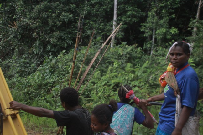
Caminant un parell d’adolesents de pesats se m’unixen dient que em seguiran tooooot el camí fins a la següent població, 4 dies caminant sense cap equipament, ni aigua ni menjar, claaaar. Òbviament no tenen res millor a fer que incordiar-me (com es provarà després) però això m’obliga a accelerar el pas per marcar ritme, i no em deixa estar en els meus pensaments. És mig fia tropical, carregat en 14kg, per tant no el millor per una agradable conversa en un pesats avorrits.
Em diuen que una australiana viatjant en canoa i yacht ha passat per allí, Laura pot ser, ho he de buscar a google.
bé, ací la noticia. No és laura, ni alemaya, però si que és 5 anys de viatge 😀
Sentiré més noticies d’ella.
Un PVM ( public motor vehicle, un camió en toldo i seients de fusta, ne les finestres de la cabina cobertes en reixes) ens agafa.
Baixem a la bifurcació, la carretera principal s’endinsa a les muntanyes, d’on camions carregats en troncs enormes de la desforestació van fins a la costa on seran venuts a la resta del món a canvi d’un poc de miserable diners que van a les butxaques de poca gent mentre ací viuen en un estat d’extrema inseguretat i destrucció de la seua cultura i medi. Wuhu! 😦
Quan els pesats avorrits entenen que aniré realment a caminar em deixen sol, no sense abans demanar-me el barret, mòbil i càmera, yeah demana demana
Camine sol perfí, cap cotxe però si roderes cosa que encara em fa pensar que en algún moment, hui o demà, algún cotxe passarà.
Pare a menjar i és obvi que no arribaré a cap lloc especial hui, hi ha un riu a 12 km on puc reomplir aigua (no hi ha al camí i només porte una botella, mala planificació en clima equatorial caminant a mig dia…).
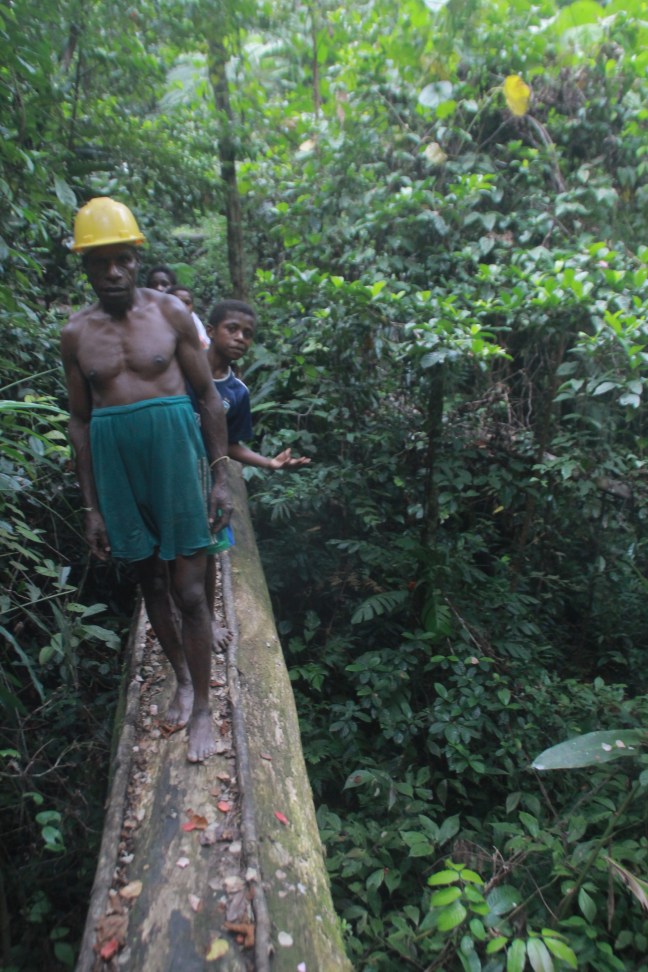
Més avant hi ha una cabanya, i prop una casa llarga sobre una muntanyeta. Molt fotogràfica (però la càmera no va). Sobre pals, sostre baix de palla, que actua de parets, terra de fusta. Unes 10 persones hi són. Demane aigua i dic que vaig a el poble que està a uns 90km ara. Estan un poc en xoc de vore’m. Els xiquets tenen les panxes unflades per malnutrició.
Continue i poc més avant altres caminants que van en direcció contraria em diuen que la carretera principal està tallada i que seguisca la nova, creuaré un riu i poc després arribaré a un poble. Deuria haver demanat més detalls, però pareixa que tot seria molt obvi, bé,no ho serà…
La 1a indicació és clara, uns kilometres més avant hi ha una bifurcació, a l’esquerra com m’havien indicat hi ha un camí, i el vell que seguis el mapa està ple de brossa i no es pot transitar.
Però al nou, tot i tindre fang no veig empremtes dels 3 caminants ( 2 adults i un xiquet) cosa que em fa sospitar que no és el camí. tot i això avance i hi ha unes excavadores com m’havien descrit.
Continue el camí i resulta clar que no hi ha cap vehicle que transite aquell camí en moooolt de temps ja que és tot un fangar i la vegetació ho invadeix tot. I hi ha empremtes humanes però, tot i que pareixen més velles que només un dia.
En comptes de fer martxa arrere i ja acceptant que el dia serà perdut, continue concloent que el camí a algún lloc durà i que ja que estic allà, from teh lost to the river (pretenc arrivar al riu del mapa)
Un arbre enorme caigut talla el camí, per si tenia cap dubte que algun vehicle passaria.
Potser allà deuria haver mirat si hi havia un sender, però simplement seguisc fins que, arribe al riu!
Bé, i el pont? cap.
Vuic veure però hi ha vora el riu marques de metalls pesats que van directes al riu, probablement un poc de mineria d’or que utilitza mercuri per a separar l’or del fang i després aquest mercuri l’evaporen i queda l’or. Els residus de mercuri van al riu com no..
El riu és fangós però no pareix profund, així que em lleve els pantalons, motxilla al cap i travessa, al mapa hi ha indicació que hi ha un camí a l’altra banda.
A aquest punt, unint totes les meues dilacions i dubtes i temps de caminar ja s’ha fet de nit i només tinc la llum de la posta per guiar-me.
El riu és passable, l’aigua no arriba més enllà que la meua cadera. A l’altre costat seguisc un camí que no deu haver estat obert fa molt en mig de la vegetació. 1km més avant arribe al que al mapa deuria ser una carretera, però ara, a la llum de la lluna, pareix un riu. mmm.. un riu d’aigua no pot ser ja que acabe d’eixir d’ell, a més és estàtic.
Serà un riu d’herba gegant, com una especie de canyís. En algun moment algú ha obert un camí allà però ningú s’ha molestat en utilitzar-lo per tant una vegetació abundant n’ha pres possessió. Bona forma d’utilitzar els recursos!
No hi ha cap forma d’avançar en mig d’aquelles plantes d’alçada humana. Temps de fer marxa arrere. Pot ser hi ha un sender en altre lloc però els qui m’han dit del nou camí clarament no m’han indicat bé i jo no he vist cap altra alternativa, a més ara és plena nit, per sort tinc lluna.
Creue el riu altre cop, ara de nit, espere que els cocodrils no estiguen desperts a la nit.
Torne pel fang, torne a escalar el tronc caigut ( el diàmetre és més alt que jo, gran arbre). I arribe a les excavadores. Prop d’allà hi ha un filet d’aigua on reomplic la botella i vec, és també marro i fa sabor a terra però és millor que l’aigua en mercuri com a mínim.
La part bonica es que per primer cop a l’equador veig la creu del sud, orgullosa apuntant al sud (cap on camine) supose que l’hibern ja és suficientment entrat per a que estiga alta al cel i la puga vore. És una visió agradable
Durant el meu trajecte he estat menjant unes herbes gruixudes, a mitat camí entre canyes i vegetals, que la part de baix de la tija és prou carnosa i té prou d’aigua. Recol·lecte un parell de grapats i això juntament amb galetes i l’aigua serà el meu sopar, bon profit!
Monte l’hamaca entre les 2 excavadores però tot i estar cobert els mosquits fan molt de soroll i no puc dormir, per tant vaig a dins de l’excavadora on acurrucat puc dormir en un plà darrere el seient, una orella està protegida dels mosquits i l’altra la cobrisc més del normal. Al cap d’una estona pareix que funciona i em deixen tranquil.
Serà bona solució ja que dec estar un poc alt i a la nit fa rosada, per tant si haguera dormit a l’intenperie sense sostre la humitat m’haguera atacat prou.
Bona nit!