Comes from 1st
-Second: walk up and then down, and…
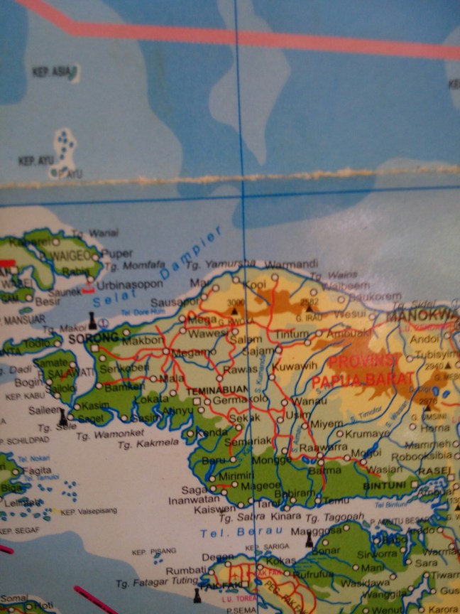
You have 100km in front of you, here the wikiloc sketch, it starts at km 41 on that track. I think in 3 days it can be done all walking, for the ones ready for it, but I recommend 4 days with 3 obvious stops on the river crossings. Or skip the last day (24km) as the road is less interesting (paved at half way) and it’s easier to catch a ride. If you come the other way that might change as it shall be less challenging and you can skip altogether the track to get there.
1st Trek
After the bridge the road starts to be unpaved. The first slope of about 8km climbs from 400m to almost 1000m. It’s almost all up with maybe 2 breaks as flatter parts. The views on your back, as you ascend, are magnificent, look back and enjoy the moment!
Fresh it took me 1h and I’m not on shape at all. The road is wide and of crushed rock. I did zigzags to put less stress on my legs. So with less weight and more prepared that shall be done easily and it’s one of the most challenging passes, the are only 2 more like that. On the sides runs fresh drinkable water, nobody lives there!
Just after getting on the top of the pass I got a ride, lucky me, a four wheel pickup. I rode on top of cement sacs and under wood panels.
What follows is mountain road with many ups and downs as it traces the mountains. Striking views.
Around 20km later an abrupt descend to a river valley forced the driver to cool the brakes with water of a hoof on the road. Few kms ahead there is a bigger river and bridge, with 5 houses there (km 63 on my wikiloc track). If you came walking I suggests to stop there to pass the night.

The inhabitants where fascinated that my ride piked me up walking the mountains 🙂
2nd Part
I continued with my pickup, after the river bridge there is another harsh ascend. We had to stop a couple of times to put rocks on the rear wheels mid slope so the car could muster enough power to clear the stretch.
Another descend cut by a river crossing with no bridge. There you shall wet your pants if you go walking but it’s passable.
I was stopped in settlement of 15 houses and 2 huts scattered in 4 clusters. Strangely they told me the name of 4 villages (3 houses per village?, maybe resettlement from somewhere, as there is no running water there), but the settlement got the name of Meia Selatan.
Continuing about 3km slowly down there is the interesting part of the trek and why it has to be done walking. “Kali (river) Sisu”, I’ll call it Cool Big River 🙂
That shall be your stop, there is a sizable village (with school) less than 1km before the river, and a road construction camp just before the river.
I crossed in 2 of the 3 possible ways (for fun) depending on your preferred method sleep on the village or camp.
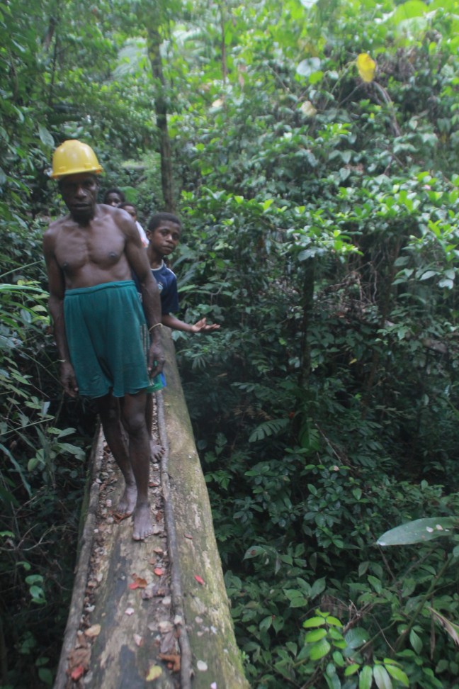
The 1st: From the village ask the locals to show you the “jimbatan”, the hanging bridge. If the road bridge is not finish yet (it might take years…) they shall bring you to a hidden small track that crosses a terrific forest using fallen huge tree trunks as bridges on the way. After the tricky path the hanging bridge awaits. No words for that, only awesomeness.
The 2nd: From the camp ask how to cross, the answer came as excavator. Yeah, cross a river by excavator, exultant awesomeness.
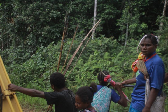
What I did, crossed by hanging bridge, found the excavator on top of the slope, it was evening, so I crossed back with it to sleep, joined by the locals back from hunting, caring their bows and arrows and mobile phone to take pictures with me XD. And next morning excavator cross again!
The 3rd method, grab a branch and follow the current until you can get to the opposite bank. A kid did it. Cool but not electronics friendly.


3rd Part
Here is where walking is necessary. There is nothing on the other side of the river, and since no cars nor trucks can cross, there is only the 2 feet (or 2 wheels, I was told in the next village that a Russian did that way some time earlier than me 🙂
I starter walking at 8 and by 10:30 I crossed the 10 km to the next village. Good rhythm. After the first slope the terrain flattens, crossing the mountain with its ups and downs.
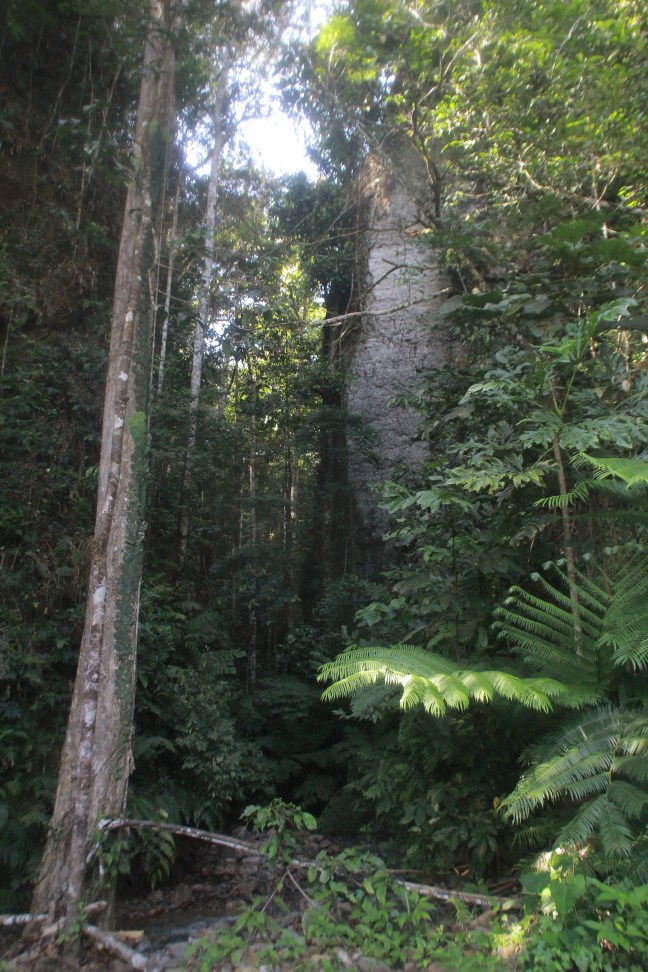
Terrific views again of pristine forested mountains.
The road in this section is scattered with excavators working, and becomes really muddy at times, but nothing reads impassable.
The town, Ayapoker, has a small shop where to fill your stomach and bags with food. The locals will fill your water (not much running water on the way) and maybe tell you about the crazy Russian and Barcelona guy who crossed before 😀
When I was there a young school teacher from Sulawesi spoke perfect English. Curious to found in the most remote village of this road.
The road slowly climbs all the way. 5km ahead there is another road camp where they offered to feed me. Since i lost 1h in the village to let pass a rain cloud, I pushed on.
A couple of km more a really small town they called Ayay, no place to eat there. I pressed on again. In 5km there was supposed to be next town. Well, not exactly.
Here what happens:
The road climbs to 900m and then down, the views of the valley down are really beautiful. A town in the middle by the river, with a telecom tower and a road climbing on the other side of the valley.
Promising, but the way down is a non visible really abrupt fall, with a excavator trowing rocks on top and a storm coming from the other side, mmm… bad.
Another excavator operator tells me the way down is 1 km or a way around it’s 2 (or so i understood). Not pleased to advance into an invisible way down with half a tone rocks falling form the excavator on top, I decide for the roundabout.
What I thought was a small service road 500m ago on the side of the road is a detour that goes up to 1100m and then down in… 12km, yeah not the best detour when a storm approaches, at the end of the day, and still steppy. My Walking sticks shorten a lot on this way.
When down you can see where the new shortcut is being build.
By the river a road leads to the town but I’m invited to a “hotel” hut by the main road, after crossing the river again.
Either the town (also called Ayay, apparently), or the “Hotel” Papua make a good stop..
I’m told there is no town (next one is Asiti), or houses until 25 kms, that will be false, again.
Optional 4th trek.
From “hotel” Papua I left early, 7:00, after I was forced to take a breakfast.
The road there continues to be unsealed but except for a couple of trunk bridges and a stream crossing, it shows the intention of being a sealed main road soon.
The morning is scenic, with clouds climbing on the rainforested mountain slopes and valleys. But other than that there is nothing to call home, only the gorge viewpoint that I marked on OpenSreetMaps (few metres inside the forest, before crossing the stream) you can find on the Maps.me app.
The road is not challenging at all anymore and after 10km it becomes paved, maybe 1 or 2 km more there is a small settlement of 5 houses or so (that I forgot to ask the name). There I saw a car pass and I piked it, no reason to walk anymore.
What follows is the most hardcore hitchhike I’ve done, and I been in really hardcore ones already, they are child play in comparison :D.