Western Dominions

To understand the networks that can establish this project’s question, it would be interesting to reflect on how such networks were created. And for that, one has to reflect on the dominance of the planet by the Western European powers by the end of the 19th century. This dominion, as described before, started with the parallel events of the arrival in the Americas, wiping out about 90% of their pre-contact population, and conquering Malacca after the circumnavigation of Africa. These two events were achieved by two small powers, inhabiting a medium-sized peninsula at the end of the Earth (Finisterre, the end of the land, is in Galicia, north of Portugal). The peninsula lies between the Mediterranean and the Atlantic and was shared with two more kingdoms, Navarra and Aragon, which did not participate in these events. Other Atlantic-facing small powers soon joined the party, with France, the Netherlands and England taking over the lion’s share the century after, and some other colonising efforts conducted by Denmark, Scotland, and even Poland. Once Germany and Italy were created, they eagerly jumped into the “game” as colonial administrators. But beyond the administrations, emigrant European populations, mostly from the western and central portions—but in reality from all over—had huge influences all over the world. And last but not least, Russia, which still holds its colonial land-based empire, conducted overland the same land conquests that the rest of the powers were conducting over the oceans.

To see the effect that about 10 nation-states had over the world, you can go to the modern world political map and start crossing over the countries and territories that at some point fell under their control, be it nominal or real, where they had actual power in deciding much of their political and economic actions.

Colored are 8 Nominally non-colonized modern nations. Turkey is in dashed lines because it can be considered a “European” power. In black is all the parts of the world where a imperial European power or their ex-colonies, plus Japan and China, took over the administration of the land in the last 500 years. Antartica is in white, under the Antarctic Treaty.

All the “New World”—i.e. America—fell under the actual or nominal control of these states or their post-independence nations controlled by European elites.

In Africa, with the exception of present-day Ethiopia (which was occupied for 4–5 years under Fascist Italy), the entire continent was nominally under the control of the Western European nations by the end of the 19th century. The African continent’s political map now bears the scars of that colonisation in the form of the terrible borders left over by the Europeans, which still today force historically antagonistic communities to share a state, while others that were historically unified are now split by an invisible line.

Oceania was swept away by the Europeans, with the Kingdom of Hawaii—one of the last remaining independent archipelagos—losing its sovereignty and most of its population to the US by the end of the 19th century.

In Asia, Portuguese, Dutch, English, French and Russian powers took over most of the land. Only six sovereign administrations were never actually controlled by the Europeans. These were the isolated Japan, large parts of mighty China, Thailand, Afghanistan, Persia (now called Iran), and the Arabian desert now controlled by the Saudis. It is debatable whether the Asian Ottoman Empire controlled parts of Europe, or the European Ottoman Empire controlled parts of Asia, but whichever it is, it had strong European influence in its administration, which can still be seen in modern Turkey. However, unlike Russia, Ottoman rulers did not intermarry with the rest of European aristocracy, in part limiting European influences in the ruling class. Other territories not controlled by the Europeans include Mongolia, which was under Qing Chinese dynastic control and then briefly independent as a puppet state under Soviet influence. Similarly, the two Koreas were under Chinese and then Japanese dominion and colonisation, and then divided in two—with the US influencing the South, and the Soviet Union and China influencing the North. The British had a mixed dominion policy. Oman (with Muscat being a Portuguese trading colony) formerly controlled great parts of the coast of present-day Tanzania due to its lucrative slave trade; that control was destroyed by the British, who then took over most of Oman’s government and internal affairs until the 1970s. Similarly, other sovereign lands—like Bhutan, Nepal, many Indian kingdoms, and Oman—at one point or another left their external political affairs and some internal ones in the hands of the British. Finally, Japan began imitating the European powers and took colonial control over Korea and large parts of China, even creating a puppet state called Manchukuo in Manchu lands in China’s northeast.

For these seven or eight places on the map that can be painted as outside direct colonial control, each suffered, to some extent, imperial influence. Saudi Arabia was mostly empty desert land with few resources until the discovery of oil, and its existence is linked to British foreign policy—to create a Saudi force as a counter-power to the Ottoman Empire at the end of the 19th century. Iran was divided into spheres of influence by the Russians and British, and its modern borders were mostly decided by them. For Afghanistan, its borders were drawn by the British and the Russians, including the strange northeastern “corridor,” which was made the width of the most powerful cannons at the time, so that British and Russian artillery could not shoot each other over Afghan territory. Most of Afghanistan’s external political affairs were controlled by the British. Thailand suffered a similar fate; being between French and British-controlled territories, it was used as a buffer state. The British and the French drew its current borders and split the country into spheres of influence, as in Iran. China was defeated first by the British, and then by a coalition of the British, French, Russians, US, Japanese, and Germans. Though they did not take full control, the British strongly influenced China’s foreign policy for decades, and China was divided into spheres of influence. Japan won several wars against Chinese administrations and took control over large parts of the land before the end of WWII. Japan itself was forced to open its borders and commerce to foreign powers when Tokyo was bombarded by a US armada in the late 19th century, and later—after some mushroom-shaped explosions—was occupied by the US and the British. It was forced to adopt an army for self-defence only and to remain aligned with US interests.

Antarctica was claimed only by European nations, and the Antarctic Treaty, which theoretically reserves these lands for all humanity, was drawn and signed by six European nations. Currently, most of the scientific bases that exist there are European ones.

Out of the roughly 200 sovereign administrations now covering the land masses of the Earth, plus Antarctica, only about seven or eight experienced little direct control by European powers. This simple map illustrates the extent to which European powers exerted near-global influence over the planet 100 years ago. Even today, of these eight territories, only Japan, China, Saudi Arabia and Iran can be said to have—or have had—notable autonomy and influence beyond their borders. Turkey may also be included, depending on which continental perspective is used. Therefore, the world remains dominated by European nations and their administrative legacies. Alternative sovereign administrations with global influence emerge only from four or five distinct cultural backgrounds. These numbers highlight how five Western European nations, and one Eastern European one, took over most of the world.

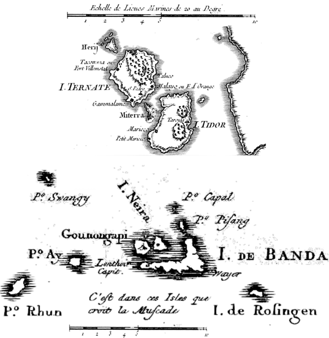
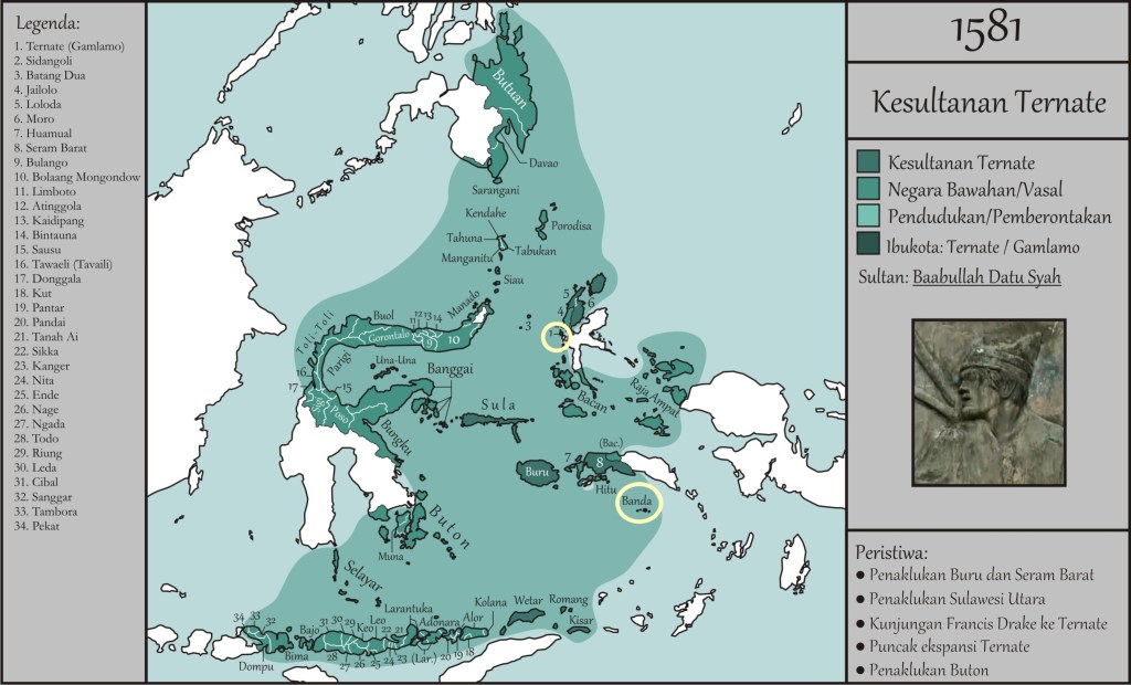
To illustrate how the Europeans went about conquering the world, let’s go back to the spice islands. The interaction between three European powers and three native sovereign powers provides three different examples of forms of dominion: by annihilation, by trade, or by playing European powers against each other. We can centre the native powers in the two islands of Tidore and Ternate, and the Banda archipelago. Similarly, we can focus on Portugal, Spain, and the Netherlands as the three European powers. As we have seen, the lucrative trade in the spice islands centred on cloves, mace, and nutmeg. Cloves are the dried flowers of a tropical tree found only in Tidore and Ternate (and some other nearby islands). Nutmeg and mace are inside the seeds of another tree, which was only present in the Banda archipelago.

As described, Tidore and Ternate are two small volcanic islands neighbouring each other at a distance of less than two kilometres. To this day, both have rival sultans. At the time of the Portuguese and Spanish arrival, each controlled its respective island and the cloves trade, plus claimed rival control of most lands east of them, all the way to western Papua. Perhaps luckily for them, the Portuguese allied with the Ternate sultanate, while the Spanish soon after allied with the Tidore one. These two sultanates had been long-term neighbouring rivals, but also intermarried, not unlike the Spanish and Portuguese aristocracies. The European powers never conquered the sultanates, although they allied with them and built forts on their territories. The Ternateans were able to expel the Portuguese after a few decades. The Tidoreans used the Spanish as convenient allies against the Ternateans.

Claimed dominions of Ternate (1, upper circle) before the Dutch appeared on the area. Tidore is just slightly south to Ternate, also circled, difficult to see. The Banda archipelago is the small islands (lower circle). Credit to https://apaitukerajaan.blogspot.com/2018/07/sejarah-kesultanan-ternate.html

Things became more complicated after the Dutch East India Company (VOC, founded in 1602 and with authority to declare wars!) took over the nearby Banda islands (Ambon), home to mace and nutmeg.

Soon after, the Ternateans placed themselves under Dutch influence to fend off the Tidoreans allied with the Spanish, who controlled half the island and even captured the sultan. After the Spanish left the area, the sultan rebelled against the VOC but instead lost independence and came under VOC rule. Ternate became the capital of the Moluccas and the wider Indonesian possessions until the Dutch founded Batavia (now Jakarta) in 1619. Today, Ternate is the capital of the North Maluku province of Indonesia, with a population around 200,000. The sultanate continued until 1975 and has now been restored by the royal family in a ceremonial role.

Meanwhile, the Tidorean aristocracy descended into infighting, ditched the Spanish and allied with the Dutch. The VOC convinced the sultan to eradicate all clove trees in his realm to strengthen their monopoly. In compensation, the VOC gave generous donations to the sultan. With the obvious impoverishment that followed losing control of the spices, Tidorean rebels allied with the British, who soon conquered it. Later, the Dutch took back control of the territory—but not before the British took seeds from the clove trees and began planting them elsewhere, beginning the end of the monopoly. The Tidore sultanate lapsed in 1905 and became a regency, but was revived to counter Indonesian independence claims over West Papua. Today, it holds a ceremonial role in the Indonesian state.

Unlike Tidore and Ternate, the Banda Islands—a small archipelago of a maximum 15.000 inhabitants south of Halmahera—were run by orang kaya, or “rich people”. As said, Banda was the only source of nutmeg and mace. These were sold by Arab traders to the Venetians at exorbitant prices. The Bandanese also traded cloves, bird of paradise feathers, massoi bark medicine, and salves. The Portuguese tried to build a fort in the central island but were expelled by the locals and did not return often, buying nutmeg and mace through intermediaries. Initially, the Bandanese were left to their own affairs, but they were unprotected by any other European powers and their artillery.

By 1609, the VOC arrived. To put it mildly, the Bandanese were not exactly enthusiastic about these slightly different Europeans, who brought only wool and odd Dutch crafts in exchange for a monopoly. Like the Portuguese, the Dutch wanted to build a fort. The Bandanese responded in the best way they could—by ambushing and decapitating the VOC representatives. The VOC retaliated, levelling random villages. In the resulting peace treaty, the Bandanese finally allowed a fort.

Meanwhile, two of the islands, the westernmost ones—sadly named Ai and Run—allied with the British East India Company, who began trading with them. The VOC launched an annihilation campaign, first against Ai (Ay in the opening post map), killing all men, while women and children died fleeing or were enslaved. On Run (Rhun in the opening post map), the natives, with the help of several Englishmen, held out for over four years but ultimately lost. Again, the Dutch killed or enslaved all adult men, exiled the women and children, and chopped down every nutmeg tree to prevent English trade. Run is the famous island that was exchanged for Manhattan (New Amsterdam) in 1667. Incredibly, the British did not replant nutmeg trees elsewhere at the time. They would only do so in 1809, during the Napoleonic Wars, ending the Dutch monopoly and making the tragedy of the Bandanese even more sorrowful.

By 1821, the VOC wanted a renewed monopoly so badly that they decided to annihilate the remaining Bandanese. They assembled an invading force of thousands of Dutch and hundreds of Japanese soldiers and launched it on the islands—then home to only a few thousand people. After a failed peace treaty, the invading commander declared that “about 2,500” inhabitants died “of hunger and misery or by the sword,” and that “a good party of women and children” were taken, with not more than 300 escaping. The original natives were enslaved and forced to teach newcomers about nutmeg and mace agriculture. At the cost of genocide—and facilitated by natural plant endemism—the VOC had a monopoly for about 180 years. The British effortlessly invaded in 1796 and 1808, and this time decided to plant nutmeg trees in another former Dutch colony: modern Sri Lanka.

Sadly, Tidore, Ternate, and the Bandas illustrate the fate of many other European colonial efforts until the 20th century: bare survival by cleverly playing European powers against one another, becoming important administrative centres at the loss of complete autonomy or independence, or facing total annihilation and repopulation of blood-stained lands. Despite these different destinies, the outcome was the same: being utterly dominated by Western European administrative frameworks, as we will see in what follows.

Previous

Next

Fragile communication

The basic structure described in the previous section allowed inland communities to have access, for example, to seashells, despite the fact they might never have seen the ocean themselves. However, one may ask: how is it that the people of Papua were still trading with stone axes in the 20th century? Even more so if the reader knows that Papua might be the oldest place on the planet where agriculture was developed, with some estimates suggesting that root vegetables were cultivated at least 10,000 years ago—slightly earlier than the domestication of grains in the Fertile Crescent.

That is actually a question Yali, an exceptional politician from Papua, asked Jared Diamond in 1972 when he was conducting fieldwork there to study ornithology, including birds such as the bowerbird. The actual question was: “Why do you white people have so much cargo and bring it to Papua, but we natives have so little of our own cargo?”—summarised as: “Why do your people have so many things compared to us?” For Yali, cargo was the generic term for all the items Westerners had brought to Papua since World War II. He was, in fact, asking about the technological gap between the Westerners travelling there and the local people.

Diamond spent 30 years developing an answer, culminating in his book Guns, Germs and Steel. In it, he presents two main theses:

First, geographically, some populations had more access to natural resources to begin with, such as plants and animals that were easy to domesticate. For instance, in Papua, the largest domesticable animal was the pig, while in Eurasia and Africa, cattle have symbolised wealth and power for generations. Papua also had no access to grain, while civilisations like the Mayas domesticated maize. Despite not having large animals, that was sufficient to develop a thriving and complex civilisation with many types of “cargo”. Additionally, domestic animals made human populations more exposed to germs, which they gradually adapted to. However, when these naturally engineered biological weapons encountered previously isolated populations, they wiped out 90 to 99% of the locals in less than a century. The pigs kept by Papuans may have spared them a similar fate to that of the Americas and the distant Pacific Islands.

The second thesis is that, due to geography, some areas of the world were better connected than others. Again, Diamond argued that it was relatively easy for trade networks to span Eurasia and Africa, with goods, ideas, domesticated foods, technologies, and ideologies spreading far in just a few generations. This was especially true for crops; species domesticated in one location often had suitable growing conditions across the climate zones from the Iberian Peninsula to Japan. This did not occur in other regions, such as the Americas, where many similar technologies had to be independently developed by both the Mesoamerican and Andean peoples. Their centres of domestication were only a few thousand kilometres apart. However, both groups had to independently domesticate crops like maize, cotton, and beans. Moreover, useful animals like the llama and crops like the potato, domesticated in the Andes, never reached the Mayas, while the writing system developed by the Mayas never made it to the Andes. According to Diamond, these gaps are due to difficult and diverse geographies. There is no easy land route connecting these American regions—dense tropical jungles, vast swamps, and rugged mountain ranges with dramatically different climates hinder the spread of domesticated species. Even today, in the 21st century, there is no road connecting these two areas. The Darién region, on the border between Panama and Colombia, remains impassable by vehicle, making it the only place on the continent without a road from north to south.

With these two main theses and strong reasoning, Diamond makes his case to answer Yali’s question. According to him, Papua did not have the species or connections that benefitted Europeans upon arrival. Europeans were simply lucky and thus came to dominate the known world. That left Papuans with a relatively limited set of food sources and restricted access to technologies developed elsewhere.

This view has been widely debated and does not fully account for the timing of major expansionist events. Still, the picture Diamond paints holds reasonably well until the 16th–17th centuries and the largest biological genocide in human history. Afterwards, the situation becomes more nuanced, as the connectivity of the world began to increase exponentially—but we will explore this in another chapter.

The limitation on access to technologies and information for the Papuans is related to our earlier examples of basic trading networks. These can only extend as far as humans can reliably reach each other at a more or less consistent pace. If mountains, oceans, and jungles must be traversed, the task may be too dangerous or uncertain to attempt. In such cases, communities at each end remain isolated. On the other hand, if obstacles are surmountable and there is a desire to connect, these networks can transform the well-being of participants. This is the case with the Eurasian and Indian Ocean trade networks. These spanned over 2,000 years, bringing silk, gunpowder, spices, and paper westward, and silver and wool eastward. Or take the so-called Columbian Exchange, where Europe plundered the immense wealth of the Americas, borrowed some botanical knowledge and cultural inspirations, and in turn colonised and Christianised native populations, erasing or warping their lands, traditions, institutions, and knowledge systems.

Returning to our earlier examples and thought experiments, these scenarios depicted only weakly connected communities. For instance, fragmented travel and exchange networks were the norm in the Papuan highlands. Although goods like axes or shells could travel freely, people could not. Residents of a group traditionally could not travel far beyond their territories or their closest trading partners. Unannounced or long-distance travel posed great risks—aggression, even death—making lone long-distance trade virtually non-existent. Commerce beyond immediate neighbours was carried out by intermediaries. Each of these intermediaries usually took a cut or incurred costs, inflating the final price of the item. This inflation could only go so far—only items of high value or buyers with considerable resources could justify the costs. This effectively limited how far an object could travel and placed natural boundaries on the kind of connection network described in the previous section. This is comparable today to drug or wildlife trafficking, where lightweight, high-value items traverse vast regulatory and law enforcement hurdles over thousands of kilometres.

Conversely, if exchange links are too weak or complex, they may collapse shortly after forming—before significant transfers of goods, ideas, or technologies can occur. This has happened countless times across different regions and eras. Think of a group of friends that never fully bonds, or a business that cannot reach its customers. Let’s consider some more striking historical examples. At least twice before Columbus, people from faraway regions reached the Americas, but failed to establish lasting presence or strong cultural exchange.

You might be thinking of one such example: the Vikings from Scandinavia in the 11th century. They arrived from sparsely populated Greenland, but their colonisation efforts in Vinland (modern-day North America) failed. Without delving too deeply into why, it’s clear they had the means to reach distant shores and found good land, but not much more. The distances were vast, the local resources were not especially valuable, the natives were not always welcoming—possibly becoming infected or hostile—and the Vikings had limited capacity for sustained support. Climate and political factors played a role, but ultimately the venture proved too costly for too little return.

The second example is even more epic and deserves wider recognition: the Polynesian crossing of the Pacific Ocean to reach the coast of South America. Sadly, we lack written records—like the Vinland Sagas—or significant archaeological evidence. But through genetic, linguistic, and species transfer evidence, we know that about 800 years ago, seafarers from the Polynesian islands reached South America. For context, that’s more than twice the distance Columbus travelled—and his crew believed land awaited. It’s also more than three times the longest Viking sea crossing to reach the Americas. The Polynesians had no clear reason to expect a continent ahead, yet they sailed into the unknown.

Imagine being in a boat no more than 30 metres long and about one metre wide, possibly connected to another boat as a catamaran. This platform allowed a few dozen people to bring animals, water, and supplies across the vast ocean. Some examples of these vessels—such as Druas in Fiji—could carry more than 200 people. Now imagine that your only known geography was a scattering of islands, and you did not know where or if more land existed. Countless such expeditions must have failed before one succeeded in making the 6,000 km journey—until finally, they found an enormous continent. Then they had to sail back, locating tiny home islands amid the ocean after weeks at sea. The adventure, mindset, skill, and ultimate success—after who knows how many failures—is one of the most remarkable, untold stories of human exploration.

This is not comparable with the Viking or Iberian voyages across the Atlantic. Those sailors knew something awaited beyond. The Vikings had seen driftwood from the west wash ashore in Greenland. Columbus, though mistaken in his estimation of the world’s size, expected land. The Portuguese, too, found driftwood in the newly colonised Cape Verde islands—Paubrasilia, or “firewood”, due to its red colour—which gave Brazil its name. All these peoples had reasons to expect land in the west.

We know Polynesians completed this journey because they brought coconuts and chickens with them—and brought back sweet potatoes, which later spread across the Pacific islands as a staple crop supporting larger populations. They also had children with local peoples, leaving genes still found today in Mesoamerican and Mapuche populations. There is even evidence of American ancestry in Polynesian populations.

This widespread gene flow shows that Polynesians not only crossed the ocean more than once but established contact across a broad swathe of the Pacific coast of the Americas. Unfortunately, the contact was not maintained over time, and no further instances of intermarriage are evident after 1300 CE. Furthermore, Polynesian navigational technology was not passed on to the local peoples. Native Americans would have greatly benefitted from such skills—especially considering the lack of transport links between North and South America even today.

We can speculate why the contact faded and the technology was not adopted—unlike sweet potatoes. In a simplified view, the connection was likely too distant and involved too few people to become meaningful. Perhaps the Marquesas Islands had only a few hundred inhabitants at the time, while the continent had millions and two sophisticated civilisations that saw little value in these distant seafarers. Whatever the case, the exchange was short-lived and limited.

More complex reasons could also explain the lack of adoption. For instance, Austronesian sailors from Makassar routinely travelled to the northeast coast of present-day Australia—around 3,000 km away—to harvest sea cucumbers for the Chinese market. This trade continued for centuries, ending only in the 20th century due to Australian colonial restrictions. Although contact endured, no lasting colonies were established, and the mixed communities that emerged never thrived. Some wives were exchanged, and a basic trade language developed, but local people only adopted simple technologies such as dugout canoes and shovel-nosed spears. More advanced knowledge may not have been shared—or perhaps locals weren’t interested.

Similar patterns emerged with Austronesian expansion to Madagascar and Taiwan. Though close to the mainland, these regions show little lasting influence on nearby East Africa or Southeast Asia. This suggests that Austronesians successfully expanded to uninhabited or sparsely populated areas (e.g. Pacific islands, Madagascar), but failed to make inroads in already densely populated regions like Asia, Africa, Papua, or the Americas.

In Australia’s case, the issue might have been resource scarcity. Northern Australia may not have offered enough to entice settlers. Local people may not have seen value in adopting agriculture or foreign technologies. Additionally, complex knowledge like seafaring is often guarded. Sailing is more than boat-building—it involves reading stars, winds, currents, and more. Mastery takes time, risk, and community effort. If local life was already sufficient, why go to the trouble?

Moreover, the fact that sea cucumber expeditions were male-dominated may have prevented the creation of Austronesian communities in Australia.

A good related example, but limited to technology and infrastructure, is the first transatlantic telegram cable. It was build in 1856 and it only worked poorly for 3 weeks until it completely failed. It took 15 years to build the successful 2nd cable. In this case a combination of affordability, technological improvement and willingness to communicate more instantly two continents made the 2nd attempt stuck. Now we have tens of thousands of underwater cables connecting all continents to transfer high speed data. But we could imagine many scenarios in which after the first failed transatlantic cable, the trend did not continue.

From the cases outlined here, we can see how many different scenarios could limit cultural and technological exchange, creating a nuanced and often unpredictable picture. Establishing sustained connections across natural and cultural boundaries is a long, fragile process—often with little success on the first attempt.

Previous

Next

2nd, The Interesting bit. Mountain bird head peninsula crossing, West Papua


Comes from 1st
-Second: walk up and then down, and…


You have 100km in front of you, here the wikiloc sketch, it starts at km 41 on that track. I think in 3 days it can be done all walking, for the ones ready for it, but I recommend 4 days with 3 obvious stops on the river crossings. Or skip the last day (24km) as the road is less interesting (paved at half way) and it’s easier to catch a ride. If you come the other way that might change as it shall be less challenging and you can skip altogether the track to get there.


1st Trek

After the bridge the road starts to be unpaved. The first slope of about 8km climbs from 400m to almost 1000m. It’s almost all up with maybe 2 breaks as flatter parts. The views on your back, as you ascend, are magnificent, look back and enjoy the moment!

Fresh it took me 1h and I’m not on shape at all. The road is wide and of crushed rock. I did zigzags to put less stress on my legs. So with less weight and more prepared that shall be done easily and it’s one of the most challenging passes, the are only 2 more like that. On the sides runs fresh drinkable water, nobody lives there!

Just after getting on the top of the pass I got a ride, lucky me, a four wheel pickup. I rode on top of cement sacs and under wood panels.

What follows is mountain road with many ups and downs as it traces the mountains. Striking views.

Around 20km later an abrupt descend to a river valley forced the driver to cool the brakes with water of a hoof on the road. Few kms ahead there is a bigger river and bridge, with 5 houses there (km 63 on my wikiloc track). If you came walking I suggests to stop there to pass the night.

IMG_0006

The inhabitants where fascinated that my ride piked me up walking the mountains 🙂


2nd Part

I continued with my pickup, after the river bridge there is another harsh ascend. We had to stop a couple of times to put rocks on the rear wheels mid slope so the car could muster enough power to clear the stretch.

Another descend cut by a river crossing with no bridge. There you shall wet your pants if you go walking but it’s passable.

I was stopped in settlement of 15 houses and 2 huts scattered in 4 clusters. Strangely they told me the name of 4 villages (3 houses per village?, maybe resettlement from somewhere, as there is no running water there), but the settlement got the name of Meia Selatan.

Continuing about 3km slowly down there is the interesting part of the trek and why it has to be done walking. “Kali (river) Sisu”, I’ll call it Cool Big River 🙂

That shall be your stop, there is a sizable village (with school) less than 1km before the river, and a road construction camp just before the river.

I crossed in 2 of the 3 possible ways (for fun) depending on your preferred method sleep on the village or camp.

The 1st: From the village ask the locals to show you the “jimbatan”, the hanging bridge. If the road bridge is not finish yet (it might take years…) they shall bring you to a hidden small track that crosses a terrific forest using fallen huge tree trunks as bridges on the way. After the tricky path the hanging bridge awaits. No words for that, only awesomeness.

IMG_0084

The 2nd: From the camp ask how to cross, the answer came as excavator. Yeah, cross a river by excavator, exultant awesomeness.

What I did, crossed by hanging bridge, found the excavator on top of the slope, it was evening, so I crossed back with it to sleep, joined by the locals back from hunting, caring their bows and arrows and mobile phone to take pictures with me XD. And next morning excavator cross again!

IMG_0125

The 3rd method, grab a branch and follow the current until you can get to the opposite bank. A kid did it. Cool but not electronics friendly.


3rd Part

Here is where walking is necessary. There is nothing on the other side of the river, and since no cars nor trucks can cross, there is only the 2 feet (or 2 wheels, I was told in the next village that a Russian did that way some time earlier than me 🙂

I starter walking at 8 and by 10:30 I crossed the 10 km to the next village. Good rhythm. After the first slope the terrain flattens, crossing the mountain with its ups and downs.

Terrific views again of pristine forested mountains.

The road in this section is scattered with excavators working, and becomes really muddy at times, but nothing reads impassable.

The town, Ayapoker, has a small shop where to fill your stomach and bags with food. The locals will fill your water (not much running water on the way) and maybe tell you about the crazy Russian and Barcelona guy who crossed before 😀

When I was there a young school teacher from Sulawesi spoke perfect English. Curious to found in the most remote village of this road.

The road slowly climbs all the way. 5km ahead there is another road camp where they offered to feed me. Since i lost 1h in the village to let pass a rain cloud, I pushed on.

A couple of km more a really small town they called Ayay, no place to eat there. I pressed on again. In 5km there was supposed to be next town. Well, not exactly.


Here what happens:

The road climbs to 900m and then down, the views of the valley down are really beautiful. A town in the middle by the river, with a telecom tower and a road climbing on the other side of the valley.

Promising, but the way down is a non visible really abrupt fall, with a excavator trowing rocks on top and a storm coming from the other side, mmm… bad.

Another excavator operator tells me the way down is 1 km or a way around it’s 2 (or so i understood). Not pleased to advance into an invisible way down with half a tone rocks falling form the excavator on top, I decide for the roundabout.

What I thought was a small service road 500m ago on the side of the road is a detour that goes up to 1100m and then down in… 12km, yeah not the best detour when a storm approaches, at the end of the day, and still steppy. My Walking sticks shorten a lot on this way.

When down you can see where the new shortcut is being build.

By the river a road leads to the town but I’m invited to a “hotel” hut by the main road, after crossing the river again.

Either the town (also called Ayay, apparently), or the “Hotel” Papua make a good stop..

I’m told there is no town (next one is Asiti), or houses until 25 kms, that will be false, again.


Optional 4th trek.

From “hotel” Papua I left early, 7:00, after I was forced to take a breakfast.

The road there continues to be unsealed but except for a couple of trunk bridges and a stream crossing, it shows the intention of being a sealed main road soon.

The morning is scenic, with clouds climbing on the rainforested mountain slopes and valleys. But other than that there is nothing to call home, only the gorge viewpoint that I marked on OpenSreetMaps (few metres inside the forest, before crossing the stream) you can find on the Maps.me app.

IMG_0261


The road is not challenging at all anymore and after 10km it becomes paved, maybe 1 or 2 km more there is a small settlement of 5 houses or so (that I forgot to ask the name). There I saw a car pass and I piked it, no reason to walk anymore.


What follows is the most hardcore hitchhike I’ve done, and I been in really hardcore ones already, they are child play in comparison :D.

Diari de Raja Ampat, dia 2 Back to the Tourism!

image

M’alce pel matí al dur i fret moll i el despertar em somriu en fotos genials dels ciquets pescant en l’albada.

Acabe de donar la volta a la illa.

Allà a les 9 en Marte, pagat per l’home de les ceves de Alken prima, em du fins a Pianemo, una llarga illa en que no hi viu ningú però és boinca per als turistes.

Gita, la meua CS m’ha dit que van allà. Descobrisc que és millor que m’arrepleguen allà ja que només  està  a 10km, en comptes dels 30km d’arboek. Finalment he entès que no compartisc viatge amb un amic, sinó  que un amic em du i paguen els locals… així que millor fer-ho barat.

El vaixellet em du a través de vistes a tots els colors del turquesa i esmerlda.

A l’illa de pianemo trobe a la Getta i 2 turistes que estàn amb ella, una suisa i una Israeliana (que té passaport de Brasil, per tant pot viatjar a Indonèsia, els Israelians no poden anar a Indonèsia).

Visitem una perdra en la mar, una illa que serà  igual d’alta que de llarga. Amb una bonica platja. Foto.

Pitnic en península blanca d’arena.

Balenes, nade entre elles però estàn massa lluny per vore-les bé. Totni això fotos xules.

Homestay en illa privada, meduses del revés en mig de fang poblat per manglars de documenal.

Arborek és una illa plana de 600m, plena de cases, en mig de barreres de corall. M’han dit que és  la illa havitada més xicoteta del món. Pot ser.

Xiquets dutxant-se baix la tempesta. Nadant, “jelly fish, jelly fish” pica però és tolerable.

conservació :
la Githa va ser contactada per un lloc de voluntariat-turisme per buscar-los una base a raja ampat
ella és Coordinadora social, i estava a Jacarta ja fent recerca i esctivint sore raja ampat abans de que la cotactaren.

Quan feia d’escout i va teobar aquesta illa, arborek, va decidir instal·lar-s’hi, i va ajudar als de volun-turisme, però després d’un temps van separar-se encara no se perquè.

els de volun-turisme són britànics.

Camine al voltant de la illa, una el·lipse d’uns 500m de diàmetre, per Pi dóna uns 2km, el que obtinc amb el GPS.

Trobe volun-turistes, hamaques, 7 hotelets, panells solars i instal·lacions hidroponiques! L’atmosfera de l’illa és totalment diferent de Pam. Més regulat tot i xiquets vestits i otganitzats.

Boat Hitchhike Sulawesi to Maluku to Papua, 8 Days in Alken Prima

image

Here I’ll  summarise my experiences of the 9 last days of my life hitchhiking  of a cargo ship crossing the dream seas of the north east of the Indonesian archipelago :D. For reference to anybody wants the info to have an amazing unique experience.

The hitchhiking itself was really easy (and lucky) one in Bitung multiple harbours. Unlike previous ports here all the harbours are open to the public. The only restriction that i found was in the big cargo container where they didn’t allow me to take pictures. Although apparently i was allowed to walk around,  the security guy was not enthusiastic…

I started with the generic cargo harbour and the third boat I asked, Alken Prima, told me that they where going to Maluku on that night (10pm) and that they had no problem in getting me in. Jackpot!

Just in case I asked ALL the harbours in Bitung. I got a couple more that told me that where going in 2, 3 days, and probably could take me, and a small one, of the likes of my first boat hitch, was going next day. But they where unsure if I would be allowed by the police. I guess with a bit of patience and trying I would have gotten into one of these, so my advice is that Bitung is a great spot to hitchhike boats!

On the Alken Prima easy ride. As I later discovered the boat is a cargo ship that circles from Bitung in North Maluku, to Sorong, in west Papua, doing a more or less scheduled 2-3-4 weeks route. The ends I guess are fixed but it changes slightly in each iteration, as I saw in their nautical charts the old itineraries.

image

So if you happen to hit on Alken they can bring you all the way on direction or the other, it took me 9 days to cross from Bitung to Sorong :D, you can wait for it!

The first thing I discovered is that it is not a normal cargo ship, but one that also carries people that go to really remote small islands. That probably explains why it was so easy to carry me.

When I went at night they had build a tent over the deck where all the passengers would stay. Well  I was not passenger and I went to the commanding cabin to take pictures of the departure. Then I slept on the open section of the deck, the stars where amazing in the moonless night. Big Milkyway crossing the celestial cover.

image

I was concerned that they might think I’m  another passenger, some crew  asked me where I was going to sell me the ticket. But I said “numpang” and that was the end of it, nobody ever asked me for money in the  following days.

I can positively say that they where happy to have me there, I don’t  know to which point because of the exotism of the “orang buleh” (white man) or because my child like behavior made them happy.

On the fist cargo unloading  occasion (anchored in a bay, far from land), I jumped to the sea, joined some locals ashore, ate coconuts, went back swimming, boarded the ship by climbing the crane net, helped load and unload the rice and cement (“semen”) into the small boats that took the cargo, and swam again. That seemed to amaze the crew and locals quite a bit 🙂

image

Anyway play your  cards and see how the game goes.

I never asked for food, but this being Indonesia they kept insisting in feeding me. It was simple fish and rice but nutritious and I was always thankful of being feed. Still when we could land I usually ate there or bought supplies. I also shared what little snacks I had.

My plan was to work helping load and unload cargo to help the crew, but soon I realized that non of the crew roles involved loading cargo, that was left for the people at the harbours to do. So after they telling me that I shall not help and since I’m  not helping them, then I never did a long term work helping on the cargo. Only small jobs when going or coming back from my excursions, allowed because of being free from the cargo work that I self imposed 😛

Anyway I did help peeling hundreds of mini onions and garlic, from what i gained the use of a motorbike for me in one of the stops 😀

One of the things that set me apart from other passengers was sleeping. I slept for the first days on the floor of the commanding cabin.

image

Unfortunately that involved sleeping next to the speakers during European Champions league, which in Asia is transmitted live at 4am…

Finally I moved with my hammock on top of the cargo next to the passengers. Although not always there where passengers, sometimes the deck was empty.

One nice thing if life on board is that you have everything that you  need, that involves also a bucket shower and a place to wash your clothes and dry them, quite convenient 😀

For me one of the most enjoyable experiences on board is simply living the cargo flow. It’s logistics in front of your nose! Seeing cargo being loaded, transported, and unloaded 3 islands away… Imagining the way that ware had to do to get there, how and when it was made, the way it will go, it’s use, and the links of people that are needed to get it to do what it has to do where it has to be, well it amazes me!

That amazement was for beng onboard and landing, but obviously one of the best opportunities is island jumping! To be so fortunate to land on remote, out of the path, islands and villages, well that is a priceless experience.

Seeing how people can  live in 1km long islands, how the culture and societies change stop to stop. Stopping in a 200 meter deserted islands, in stray cat islands, stray dog islands, talking about cannibals and seeing their weapons, the mixture of curly haired, blond Papuans and smooth haired dark Indonesians, with their own huge range of diversity …

Then the camaraderie of the crew, the atmosphere of feeling welcomed and happy to see you that is common in Indonesia, gets a boost if you add the feeling of being part of a  crew.

Playing games, helping on small task that you can, eating with them, swimming, discussing the nautical charts, talking about everyday life. Wondering why there is a chicken tied to a hole under the commanding cabin…

image

Finally the sea life. Sea, waves, the scenery and islands coming and going, dolphins, whales, sunrises, sunsets, stars, milkyway…

All in all, if you have the time try to hitchhike a boat! even if you are not successful just wandering on the harbours and sea front is a photography wander! Boats, old and rusty and shipwrecks, to new and shiny. From small and colorful to huge and black and white. Frenetic activity or ghost harbour. Colours, goods, cranes, cables, fish, water, sea… On addition on many cases feeling that you shall not be there yet you are (until they detain you :). Finally the odd chance of being accepted in one of that monsters, and the adventures that await!

image

Crossing Towuti and Matano lakes from Kendari to Bateleme, Southeast – south – central Sulawesi, Indonesia

Again it’s an Adventure that it was on my plans doing but I got to unfortunate misinformation with my hitchhikes and unreliable maps. Fortunately I got to the point in which I can recommend it and fill some of the information holes I had.

Still it’s not gonna be easy and it would be better if you have your own cross country motorbike.

Starting from Kendari the best is to ask to go to Wanggudu (a small empty administrative town).
From there to Padalere to take the motorbike road to Tocalimbo (or simply  Limbo). It shall be about 100km of crappie road so plan to stay overnight on the road if you started from Kendari or spend the whole day doing it.
That at leas for now will allow you to avoid 5km of hyper muddy mountain road on the provincial road. I did it and the trucks backfell.

There is not gonna be much hitchhikes as the area is mostly deserted, but that shall not put off daring adventurers 😀 (I palmed to do it and by far I’m not the craziest out there).

Then when you get to Limbo (so cool to say that, specially now that the church says it doesn’t exist :D) on the shores of Danau Towuti. There I thought it was the problem, where to go next! However through my alternative way I discovered where to continued from Limbo 🙂

There are few boats and a personality flouting wooden ferry on the morning-noon that go from Limbo (on the southeast shore) to Kampung Baru (on the north west shore) and the other way around, so crossing the biggest lake in Indonesia with magnificent views 😀

Then from there to  Soroako (try the street food on Soroako!) and crossing Danau Matano to Nuha (or Nua) is a easy feat, that’s  the one I did in reverse. There are small 4 legged stable boats that continuously do the 20min crossing for 25.000r, they can also cross your moto (I saw one impossibly carrying 3 motos and many passengers :P).

image

From the small 8 houses settlement of Nuha to Bateleme, there are no towns, so the hitchhike is difficult. I had to walk for 1h on the mid day equatorial sun :P. The first half of the road, until crossing the province border, it’s quite potholed but easily doable, after its good road, shadowy by rubber trees close to the end.

On addition there is a road from Nuha  to Malili, around the lake, but considering that the Alpha male took the wheel of my ride at that point, but was instead copiloting until in the potholed road, then I assume the road is terrible from there on and you need experience. The beginning did look terrible.

I would say the crossing takes at least 2 days depending on the boats that you find to cross Towuti, but count on 3 days to be sure.

As always count on people super happy to see you, many pictures taken of you, remoteness, untouched scenery, cristal lakes, striking views and unknowns 😀

Good luck and Adventure!

Wanderer

image

I guess there is a point in your traveling in which you cross some kind of barrier and you cease to be a traveler: someone who wants to go to one place and do something. Then you become a wanderer: someone that wants to keep moving regardless of the way or the destination, only the movement itself and unexpectedness of your encounters are the aims of your way, one who wonders.

The wanderer though still has the legs of a traveler and the eyes of a tourist. It’s the envelope of the 2 with something else that is bigger that the sum of the parts.

It just feels right to be in the middle of somewhere that nobody would wish to be. That you belong to that moment. But the moment goes away and your traveler legs set the next step, and your tourist eyes make joy of it.

Just wander and let it go.

image

Borneo diaries Days 24 & 25, Biduk-Biduk, BidukBiduk, Biduk Biduk, beach hidden paradise, east Kalimantan, not in lonlyplanet :D

image

I’ll indulge and write this in English because it has to be shared with the world! Catalans are not enough to conquer this :P.

There is no way in which I can overstate how perfectly beach paradise Biduk-Biduk is, and I been in Majorca, Menorca, Guadaloupe, Tenerife, Nicaragua pacific coast, Phu Quok island, Vietnam coast. The fact that I just met it without expecting it might bias me, but still there is no way I can exaggerate using mere words and photos.

Where to start? lone trees hundreds of meters inside the sea? that’s a peculiar image, but it is just part of the turquoise cristal waters touching long white coral beaches, that at low tide are hundreds of meters wide (thus explaining the trees). Around 40km of tall coconut trees beach road. Villagers fantastically smiling, helpful, eager to interact, living in beach houses with grass lawns perfectly trimmed by the cows and goats that wander around. Beach cows. Evening mixed gender volleyball.

That’s the general 40kms image, broken only by some mangroves forests that extend on the beach, specially on the coast facing east. That makes it even more interesting on high tide as you have unique forested beaches with fresh/salt water mix, and walking tree climbing fish that jump over the water! yes, you entered a nature documentary.

image

If that’s not good enough there are beauty spots, local attractions and 3 small islands (from Teluk Sulaiman to Sugeindin pulau; a group of 7 Indonesians paid 150k rupiah per person 3h excursion), this would keep you entertained!

These spots include 2 or 3 medium sized rivers with complete transparent cool fresh water (the first wide river with clear waters that I see get to the sea!). One of which, Labuan Cermin (pronounced labuan jambir) has a boat service (quite expensive I heard) that drives you to a turquoise lake that has a top layer of fresh cool water and a bottom layer of salt warm water. That’s supposed to be the main attraction here, but I saw no tourist there 🙂

image

Other attractions include what can be seen on the map. Accessible are the rocks beach (pantai batu dua), literary 2 rocks beach, and Labuan Cermin harbour, full of delightful fishing vessels and cristal waters. You can do long walks, get a bicycle or moto (I still don’t know how, my host simply offered me a motorbike but I took the bicycle :D) or hitch a ride, really easy to do with the locals eager to help you.

image

The roads are well paved and virtually flat! And the tidal beach has so fine sand and so compact that you can ride your bicycle in there (but still becomes tiring after few kms). Seeing the fast running crabs moving fast as you pas has no price 😀

image

For the southern spots there is need of transport because the road is not paved, but mostly because of the lack of transport to hitchhike and long distances to walk. I guess there are no villages, or only few on that road. The road is not signaled at all. The coordinates of the entrance are:
1.173659 118.76805

I didn’t have the time to explore the waterfalls and cave, but I figure it would be close to impossible to find without a guide as there is no signaling… Something fun discovering 😉
This area is surrounded by sizeable mountains, 400m tall at least, so there is also a hike to be done!

There are at least 5 or 6 accommodations that I could see, stretched for few kms (hotels, losmen, guesthouses, homestays). I don’t know the prices as I planed to camp but was invited to a policeman house :). It shall be local price as the only tourism that I seen seems Indonesian (all the tourism in I’ve seen 3 days amounts to just one lone traveler, the 7 people group and 2 girls taking pictures). The info and signs are only in Indonesian, except for few “welcome”.

If still the accommodation is over budget you can hang your hammock in between 2 coconut trees, or if it rains, camp anywhere, or pick an empty or in construction house. Or just like me, law of solo travelers, let things happen and you might get hosted by a local 😀

image

But not all is perfection in paradise, few things missing:

Hammocks! There are non, a beach paradise without hammocks is not complete, but that has easy solution (specially when I’m carrying one :D).

Backpackers community. That might seem like a good thing but there is plenty of room to be alone if you wish, so having someone interesting to talk with (backpackers usually are) would be a good distraction. Also backpackers means books! and books are the best company in this environment.

-There are not many activities. The most engaging that I did involve peeling one or two dozens of coconuts, teaching kids English, climbing sea trees, teaching kids how to swim, selecting and unloading landsat fruit from cargo ships, fishing with a hook and swimming with kids in between the cargo boats. Last but not least, hitchhiking a boat to Sulawesi (the reason I came here, more on that on the next post 🙂

Despite these, and being aware that they are not everyday activities for many, extra distractions by fellow travelers are welcomed, specially for long stays. That’s why I’m writing this, this place could easily be a backpacker paradise 😀

Internet. On the no distractions side, there is no internet connection trough 3G, although there might be some internet cafe, ask around but don’t expect high speed… I did get 1G in certain areas for a working instant message (text only) communication.

English . Don’t expect anybody to speak more than few words in English if at all 🙂

Trash collection. The trash on the floor is not widespread luckily, but you do spot it here and there.

Transport. As far as I’ aware there is nothing like a bus, and the road connecting here to Tanjung Redeb (the closest city) is not even in google maps (but it is on openstreetmaps for most of the track). It is quite bad for the first 100kms or so. I Hitchhiked here the 250kms in 6 or 7h. If you have your own transport this is an ideal destination. And it might be that there are some boats to Tarakan, but I’m not sure.

-No easy swimming at the afternoon. In the equinoxes the tide is maximum and minimum in the equator, specially in new moon.That means that for low tide (afternoon to evening) the water is hundreds of meters from the shore. It’s a nice walk with plenty of sea life (fish, running and burring crabs, sea stars), but the hard noon equatorial sun reflected on the white sand has no clemency. Still the morning and evening swims are amazing, and you can get yourself in one of the rivers for noon, or simply nap on a coconut tree shadow.

Known future. I don’t see risk of any big development threatening this parts, but nature might. I seen plenty of spots where is clear that storms are eating the coast, therefore some stones and concrete barriers are being build affecting the beauty but protecting the road and houses. I don’t know how fast the destruction is but at some point this is meant to look different.

All in all it’s so amazing that I could not stop greening for hours realizing how luckily I was to be there.

Diaris de Borneo, dia 23, solo traveler law

image

Empirical law, developed after many events.
Law of solo travel: Let things happen! (but not for a long time in the same place, a traveller gotta travel)

Autostop a Kalimantan altre cop, un es pot tornar addicte a açò!

Després d’agafar l’speedboat a desgana (8€ més) ja que m’asseguren que no hi ha transport a Tarakan fins Sulawesi, desidisc continuar el meu camí cap al sud on el couchsurfer m’ha dit que en el punt més proper de Borneo a Sulawesi hauria de ser prou més fàcil creuar. El lloc és Biduk-Biduk, a recordar.

Si tot va bé hauria d’arribar hui allà, però promte Recorde com Kalimantan t’atrapa.

El vaixell em deixa en meitat del no res, on per tant està INFESTAT de taxistes pesats típics del SE asiàtic. Per consol són pesats en tots, no només jo. En tot cas em toca caminar prou fins que fugisc de la seua influència.

Un home m’agafa en la moto i insistis en trobar a algú que li traduisca a l’anglès per entendre que vuic, fins al punt que em du a un hotel on treballa un amic seu i em tradueix. Em conviden al 1r dinar del dia. Fotos i els demane si em poden deixar en la carretera principal per continuar l’autostop.

Em deixa a la intersecció on André em replega en moto i em du fins la seua entusiasta família que criden molt com si haguera arribat algú de Hollywood. Mooltes fotos i 2n dinar del dia.

Altra intersecció i m’agafa un camió conduït pel Mikel, a la foto, en música canyera que em deixa en meitat del no res.

El 1r cotxe que passa és d’en Sudit, en qui tinc el 3r dinar del dia.
Sudit, que no parla anglès, em vol solucionar la continuació del viatge, cosa que irònicament farà que no conrinue.

Em presenta al seu treballador, Ian, que també em vol ajudar però que en comptes de de deixar-me a la carretera em du a casa d’un que és de Biduk-Biduk (on vuic anar) i allí perc 2h en que intenten aclarir que vuic i sí ells poden buscar-me transport.

Em busquen també un amic que parla anglès i ell fa més averiguacions sense èxit. Cap a les 5 i poc és evident que no em poden ajudar i em diuen si em vuic quedar allà o continuar. Difícil decició, però seguint la regla 1 desidisc continuar tot i que queden 50min fins a la posta de sol.

Em comencen a conduir i quan és evident que no pararan a temps que puga agafar altre transport faig marxa arrere i dic que res, que passe la nit amb ells.

Em conviden a sopar un cranc bonisim. Després el que parla anglès em du a sa casa. És mestre d’anglès però treballa d’agricultor tradicional, venent-ho al mercat a les 4 del matí. Li dic si em puc afegir al mercat i diu que no problema. Però a l’arribar a casa de son germà diu que no és apropiat que dorma allà i m’envia a una NGO que es diu yakob.org

LA ONG ha estat una magnífica troballa. Bàsicament es dediquen a formar a les comunitats rurals de com tindre un desenvolupament sostenible. Ho fan a través de les escoles i de la xarxa de mestres joves que el govern envia a zones remotes per guanyar experiència nomes graduats (és un concepte molt xulo per educar els educadors, tot i tindre el contrapunt de que l’educació es dirigida des del centre i no per la comunitat local com és el model que m’agrada). Les comunitats remotes no tenen ni accés a mòbil.

Em confirmen el que m’havien dit abans, que les ONG no són benvigudes per les comunitats locals i que només
volen els diners fàcils, per tant
han de fer molta feina de conscienciació.

La tècnica que utilitzen per aproximar-se és, com els fundadors tenen mol bon nivell d’Anglès, donen classes gratis als escolars per millorar l’anglès i així aproximar la comunitat en el mssatge de conservació.
La ONG té  només 4 anys però ja tenen un antic edifici colonial on organitzen moltes coses, 9 pobles on treballen i diners de Noruega (a través d’un fons local). Els fundadors són joves i molt energètics.

Hi ha 3 mestres més  que passen allí la nit. Una ensenya canvi climàtic a les comunitats.

Conversa molt agradable  i enriquidora. Vaig a dormir tard.

Crossing to Sarawak from Kalimantan on the Nanga Badau / Lubok Antu border crossing. Indonesia to Malaysia.

image

I planed to do this crossing but due to a change of plans and a bit tried of the palmtrees landscapes and tabacco I changed plans.

In any case, I leave my advice here in case any adventurer wants to try the challenge.

Here it says you can go out Indonesia through that border, specially if you got the visa.

http://www.indonesianembassy.org.uk/consular/consular_visa_type_free.html

Look at the land border crossing Nanga Badau.

Here it says you can cross that border to enter Malaysia

http://www.sabah.com.my/borneotrade/g3.htm

I don’t know why it’s a sabah webpage but it says that the  Lubok Antu  border is open, so with the visa free malaysia for most of western countries it shall be fine.

It’s doable, even knowing only few words in Indonesian. At least there are busses all the way to Putussibau, although I been traveling by hitchhike. The road conditions go from good to horrendous, although any traveler willing to go there probably is familyar with that. In any case  it’s better to take it slow to enjoy the experience. The experience means, according to my previous ones, a lot of good friendly attention, a lot of free sugary drinks and fried food, palmtrees, invitations to peoples houses, tobacco, and many nice surprises.  It’s worth any effort put into it for sure.

People is gonna be extremely happy to see you,  so you need to set time to hang out with them and let things happen. Also it’s good to have the time to go to see interesting things that might be along the way or might be off way but worth the time to go there. Specially if invited by a locals 😀

Don’t expect, as you shall know, predictable schedules, good roads  (specially in rainy season), comfort, English,  other travelers,  a lot of traffic easily to hitchhike. But expect to be piked  up eventually. They don’t know what hitchhiking is but if they stop, with time and patience and mimics you get to your destination. Get the names of where to go though!

Then seeing the map I would think that there shall be a shortcut that does not go thorough Putussibau but I haven’t found any map showing any roads … That doesn’t mean that they don’t exist,  so if you are confident on your Indonesian ask for them.

All the best and good luck!